Exploring the Origin |
|||
|
Rockfalls and debris flows begin to pour down both sides of the valley toward them; the river swells into a thundering, muddy canal. Unwilling to turn back, Tutubalina, Chernomorets, and three other team members head upstream as fast as people with heavy backpacks can move through a pathless maze of mud, ice, and rocks. They set up an intermediate camp away from the river near the hot springs at the headwaters of the Genaldon River. They soak in the hot springs, watching the rain die down, and knowing they were lucky to have found a safe route between the violent river and the crumbling slopes. “From the beginning we knew the most interesting thing scientifically was the site of the collapse, the top of the glacier, but on our first visits, it was so blocked by debris and ice that we hadn’t been able to get to it yet,” Chernomorets recalls. Some people were still attributing the event to a glacier surge, and others were blaming it on unusually high snowfall that season. The volume of the temporary lakes and the flooding that accompanied the avalanche suggested a hidden reservoir of water in the glacier. Many scientists had come to the conclusion that volcanic and tectonic processes were responsible. To decide which explanations were most likely, they needed to investigate the site where the disaster originated: the Kolka Glacier and Mt. Dzhimarai-Khokh. |
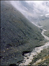
 Fog, rain, slippery rocks, debris flows, and swift streams make a trip up the Genaldon River to the Kolka Glacier a dangerous journey. (Photograph courtesy Sergey Chernomorets) | ||
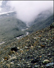
In the early morning after their scare in the thunderstorm, Tutubalina, Chernomorets, and their team awoke early. “You must arrive at the base of the glacier early in the day to cross the Kolka stream,” explains Tutubalina, “because the Sun comes up and melts the ice, and the stream grows and cannot be crossed.” They arrived at the base of the Kolka Glacier while the stream could still be crossed. After months of waiting, they were finally there. |
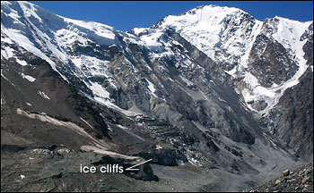
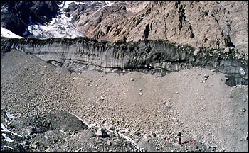
Mount Dzhimarai-Khokh, elevation 4,780 meters (15,682 feet), towers above the Kolka Cirque. Rock and ice falling from the steep walls of the cirque triggered the collapse of the Kolka Glacier. The former height of the Kolka is indicated by the steep ice cliffs in the bottom center of this photograph. (Photograph courtesy Olga Tutubalina) | ||
Watching their feet as they walked among the ice and rocks in the moraines below the glacier, they saw something none of them had ever seen before: numerous rows of parallel scratches gouged into the rocks. These striations, as glaciologists call the scratches, are usually only seen on the bedrock underlying a glacier. They are made over years or decades as the glacier creeps down a slope and etches the rock beneath. |
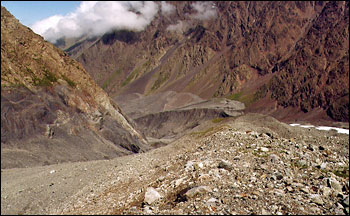
A moraine of glacially-deposited rocks marks the confluence of the Kolka and Maili glaciers. The Kolka Glacier avalanche raced over the terminus of the Maili, scarring the rocks of the moraine. A short distance beyond (in the background of this photograph), rocks and debris climbed high up the slopes of a sharp northward turn in the valley. (Photograph courtesy Sergey Chernomorets) | ||
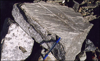
Petrakov emphasizes how unusual this is. “Glaciers have cycles of advance and retreat. When the glacier retreats, ice-embedded rocks at the edge of the glacier are exposed. When the glacier advances again, the rocks are just pushed along in front. Moraine rocks are not scraped by the glacier because they move with it. But at Kolka, the collapse happened so fast that the ice mass must have simply flown over the moraine, producing striations several millimeters deep in minutes.” The depth and direction of the striations created a snapshot of the avalanche as it passed through, and the scientists used their observations to reconstruct and map the first stages of the avalanche. Almost a year after the disaster, the slopes of the scoured cirque and the exposed face of Mount Dzhimarai-Khokh were still unstable. Seven separate couloirs (ravines) on the north face of the mountain were still actively collapsing, with continuous rock falls, ice and snow avalanches, and debris flows every fifteen minutes. “That kind of activity is unheard of, especially so long after the initial event,” says Petrakov. Glaciers that once crept down slopes and fed the Kolka now ended in precarious-looking ice walls. A particularly unstable-looking one that was dissected by gigantic parallel crevasses was being bombarded with rockfalls from above, triggering ice avalanches that spilled onto the bottom of the cirque. |
Scratches on the surface of rocks of the Maili Glacier’s moraine show the violence of the event. The avalanche, moving up to 180 kilometers per hour (112 mph), scoured the rocks below, leaving parallel grooves called “striations.” Striations are typically observed in the bedrock underlying glaciers, created by the slow, scouring action of rocks caught beneath the ice. (Photograph courtesy Sergey Chernomorets) | ||
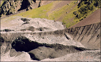
Fast and FuriousAmong all the unusual findings, however, the most shocking things about the event were the most simple—the immense volume of debris and how fast it moved. Using an image-analysis computer program, the scientists compared the results of a laser-ranging topographic survey of the ice and debris backed up behind the Gates of Karmadon to pre-disaster topographic maps of the region. They estimate that the avalanche deposited between 105 and 125 million cubic meters of ice and rock in the Genaldon Valley upriver from the Gates of Karmadon. An additional 20 million cubic meters of material were deposited in various parts of the valley. If it had had the room to spread out,that much material could have covered all of Washington, D.C., (176 square kilometers, or 68 square miles) with a layer of ice and debris more than 2 feet thick. Confined within the slopes of the Genaldon River valley, the block of ice reached heights of 130 meters (about 390 feet) at the entrance to the Karmadon Gorge and stretched back upriver for miles. Several clues pointed to enormous speeds. Normally avalanches and debris flows will follow the bottom of a river valley. In the Genaldon, however, the velocity of the avalanche was so great that in places the debris climbed the walls, creating pushed-up piles of debris called “super-elevations.” The Kolka Glacier basin makes almost a right angle where it turns north into the Genaldon valley. Rushing too fast to make the turn, the avalanche left a super-elevation 150 meters (almost 500 feet) high on the eastern slope of the valley. When the mass arrived at the Gates of Karmadon and could not pass through the narrow opening to the gorge, it crashed like a wave against the mountains and left large super-elevations high above the valley floor. |
Ice cliffs frozen to the steep rock walls of the Kolka Cirque are nearly all that remains of the Kolka Glacier. The person standing at the bottom right of this photograph is dwarfed by the ice wall and the talus slope beneath it. (Photograph courtesy Dmitry Petrakov) | ||
A more chilling estimate of the flow’s velocity was provided by seismic recorders and a power plant clock. “The seismic recorders on five seismic stations in North Ossetia recorded the first vibration of what was probably the collapse of the hanging glacier from Dzhimarai-Khokh onto Kolka,” says Tutubalina. “Five and half minutes later, according to a clock at a nearby power station, the main line into Karmadon was destroyed.” If those clocks were reasonably in sync, the avalanche would have been traveling at 180 kilometers per hour (112 mph) when it hit the power line. Eyewitnesses describe hearing the thunderous roar of the avalanche and seeing sparks in the night sky. |
Rocks stranded on the slopes above a bend in the Genaldon Valley manifest the speed of the Kolka collapse. When the avalanche debris reached the turn, it climbed 150 meters (almost 500 feet) up the valley wall. The piles of rock and rubble that remained on the slopes are called “super-elevations.” (Photograph courtesy Sergey Chernomorets) |