 | |||
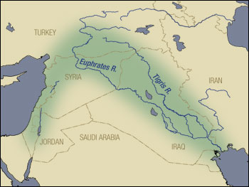
High in the mountains of Turkey, ravines and gullies collect water that becomes the Tigris and Euphrates Rivers. Flowing southward to the Persian Gulf across southern Turkey, Syria, and Iraq, the rivers drip life into the arid terrain. This area of water in the desert is part of the Fertile Crescent, a swath of well-watered land that hugs the eastern coast of the Mediterranean Sea, peaks in southern Turkey, and trails southward through Mesopotamia—the land between rivers—in Syria and Iraq. This region gave birth to Middle Eastern civilization more than 8,000 years ago. Plant and animal domestication, irrigation, and new tools launched an agricultural revolution that transformed roaming hunter-gatherers into a socially complex, permanent society. |
| ||
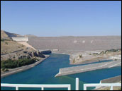
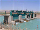
Almost a hundred centuries later, another kind of agricultural revolution is underway in the northern part of the Fertile Crescent, this one due to a major infrastructure development in Turkey’s Southeast Anatolia region that will provide irrigation to 1.7 million hectares (4.2 million acres) of new farmland. Among the most significant milestones of the project was the completion in 1994 of the first of two water-delivery tunnels that will tap the lake behind the Ataturk Dam to water the plains of southeastern Turkey that lie north of the Syrian border. |
The Fertile Crescent (green) extends northeast from the Sinai Peninsula, bordered by the Mediterranean coast and the Jordan River, then curves to the southeast, following along the Tigris and Euphrates valleys. Humans first created agricultural settlements here over 8,000 years ago. (Map by Robert Simmon) | ||
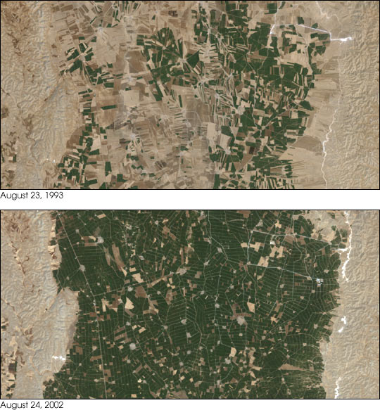 | |||
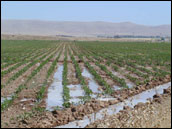
These Landsat images compare the amount of irrigated cotton grown in the Harran Plains of southeastern Turkey in 1993 versus 2002. In the 1993, before the completion of the first tunnel, the water available for irrigation came from deep bore holes, which supported only localized crop production. By 2002, irrigation water was coming almost entirely from the Ataturk Dam and Reservoir. Irrigated cotton area grew by more than 50 percent during the nine-year period, bringing an additional 450,000 acres under cultivation. Although the hot, dry weather of late August has left the surrounding landscape parched and dusty, the Harran Plains are thick with green cotton plants in the image from 2002. While irrigation is crucial for much of the agriculture in the region, it is not the sole source of water used for farming. In general, precipitation in the Middle East is concentrated within a relatively short period of the year between late October and early April. Consequently, the major rain-fed crops of the region, wheat and barley, are grown during the winter months and are ready for harvest in late spring and early summer. |
The arrival of irrigation water from the Ataturk Reservoir transformed the Harran Plains. Instead of relying on deep wells, cotton farmers have access to plentiful water diverted from the Euphrates River. These images, acquired by the Landsat 5 (1993) and Landsat 7 (2002) satellites show the increased area of green fields during the summer dry season.
(Images courtesy USDA Foreign Agricultural Service PECAD) | ||
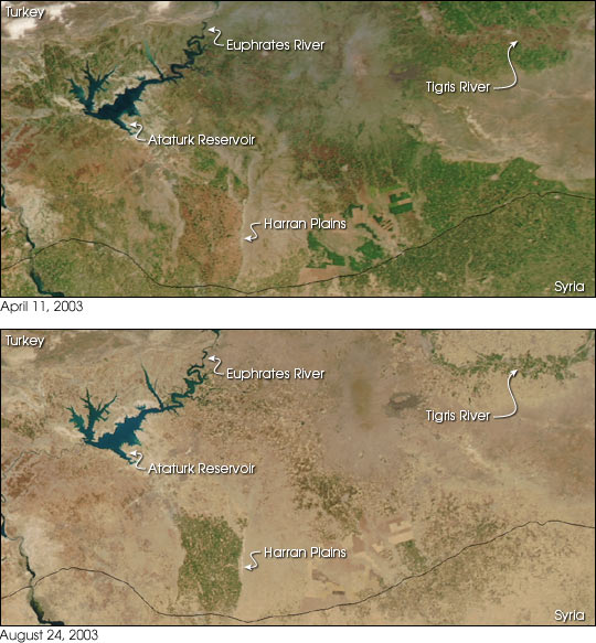 | |||
On a wider scale than the Landsat images, these MODIS images show the contrast in vegetation at the end of the winter rains in April compared to the dry summer month of August. Green vegetation in the April image indicates rain-fed grain crops, while green vegetation in the August image shows where irrigated crops are grown downstream from the major reservoirs along the Euphrates River. The Ataturk Reservoir of Turkey is the reservoir located to the north, and the Assad Reservoir of Syria is located further downstream. The irrigated Harran Plains that were shown in the Landsat images rest on the Turkey-Syria border and stand out as clearly in the August MODIS image as they do in the Landsat pair. In April, while a thin blanket of green covers wide areas of Syria (bottom) and Turkey (top), the reddish soil of the Harran Plains creates a large, mostly bare rectangle. In August, the brief lushness of the spring landscape has faded, leaving summer heat to bake the pale, arid soil. Only irrigated crops remain green at this time of year. The Harran Plains and a swath of green to the east along the Tigris River testify to the power of water to transform a desert into farmland. Southern Turkey is just one of the many locations around the world that the Production Estimates and Crop Assessment Division (PECAD) of the USDA Foreign Agricultural Service monitors with satellite imagery. Their goal is to provide an early-warning system of unusual crop events, growing conditions, or agriculture damage that may critically affect U.S. agricultural markets and trade. The group compiles various sources of information, such as field reports, daily weather data, crop models, and economic data into agricultural intelligence reports on crop condition and production estimates. But even with all these sources of information at their disposal, satellite observations like those from MODIS are invaluable, according to PECAD scientist Curt Reynolds. He says that satellite imagery is especially critical in assessing crop conditions because it provides visual data in regions where that kind of information is often difficult to obtain. It’s more timely and reliable, and often more complete than conventional sources. In addition, satellite data are inexpensive when compared to the cost of maintaining staff in overseas offices or continually funding foreign travel for U.S.-based crop analysts. The MODIS sensors onboard NASA’s Terra and Aqua satellites provide daily observations of global vegetation with enough spatial detail to be useful on a regional basis. That’s just the kind of information PECAD needs. Through a partnership with the MODIS Rapid Response Project at NASA’s Goddard Space Flight Center, near-real-time satellite observations are processed and delivered to PECAD via the Web within two to four hours of when the satellite makes the observations. For more information on crop health worldwide or details about agriculture and irrigation in Turkey, visit the Website of the Production Estimates and Crop Assessment Division of the USDA Foreign Agricultural Service.
The data used in this study are available in one or more of NASA's Earth Science Data Centers. |
The irrigated crops in the Harran Plains flourish while the surrounding countryside dries out. These images compare the wet (top) and dry (lower) seasons. (Images by Jeff Schmaltz, based on data provided by the MODIS Rapid Response Team)
(Photographs courtesy USDA Foreign Agricultural Service PECAD) | ||
