The Earth Observatory has published its last Image of the Day on this website. Please join us on our new home at science.nasa.gov/earth/earth-observatory.
Gravity. What is it? You can’t see it. You can’t smell it. You can’t touch it. But, it’s there. In fact it’s everywhere. We are familiar with gravity because we live with its effects every day. We know that when we drop an object, it falls to the floor, and we know gravity is the reason. While the force of gravity is weak compared with other forces in nature, such as electricity and magnetism, its effects are the most far-reaching and dramatic. Gravity controls everything from the motion of the ocean tides to the expansion of the entire universe.
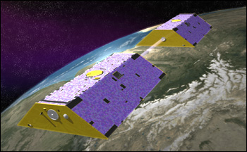
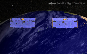
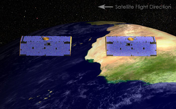
The GRACE mission detects changes in Earth’s gravity field by monitoring the changes in distance between the two satellites as they orbit Earth. The drawing is not to scale; the trailing spacecraft would actually be about 220 kilometers behind the lead spacecraft. One of the NASA Earth Science Enterprise’s focus areas is Earth Surface and Interior studies, which includes studying the gravity field. The Gravity Recovery and Climate Experiment (GRACE), launched by NASA on March 17, 2002, is revealing more detail about the gravity field than has ever been available before. Data provided by GRACE are substantially improving our knowledge of Earth’s gravity and of a number of important aspects of global change. How does GRACE really work? How is it possible for a satellite in space to make such a precise measurement of gravity from so far away? It seems like something only an expert in gravity studies could understand, and we might think the details are beyond our comprehension. Perhaps, however, if we take another look at how this familiar force really works, we can begin to better understand how GRACE measures gravity from space. next: Gravity 101 |
by Alan Ward
GRACE |
Gravity. What is it? You can’t see it. You can’t smell it. You can’t touch it. But, it’s there. In fact it’s everywhere. We are familiar with gravity because we live with its effects every day. We know that when we drop an object, it falls to the floor, and we know gravity is the reason. While the force of gravity is weak compared with other forces in nature, such as electricity and magnetism, its effects are the most far-reaching and dramatic. Gravity controls everything from the motion of the ocean tides to the expansion of the entire universe.
The GRACE mission detects changes in Earth’s gravity field by monitoring the changes in distance between the two satellites as they orbit Earth. The drawing is not to scale; the trailing spacecraft would actually be about 220 kilometers behind the lead spacecraft. One of the NASA Earth Science Enterprise’s focus areas is Earth Surface and Interior studies, which includes studying the gravity field. The Gravity Recovery and Climate Experiment (GRACE), launched by NASA on March 17, 2002, is revealing more detail about the gravity field than has ever been available before. Data provided by GRACE are substantially improving our knowledge of Earth’s gravity and of a number of important aspects of global change. How does GRACE really work? How is it possible for a satellite in space to make such a precise measurement of gravity from so far away? It seems like something only an expert in gravity studies could understand, and we might think the details are beyond our comprehension. Perhaps, however, if we take another look at how this familiar force really works, we can begin to better understand how GRACE measures gravity from space. next: Gravity 101 |
by Alan Ward
GRACE |
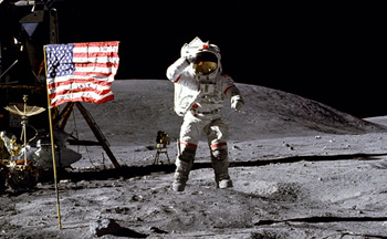
Gravity 101 We can think of gravity as the invisible force that pulls two masses
together. When we speak of mass, we’re talking about the amount
of matter in a substance. Density is a measure of how much mass is concentrated
in a given space. Sir Isaac Newton discovered that as an object’s
mass increases, the gravitational attraction of that object increases.
For example, a container filled with a more dense material like granite
rock has more mass and thus more gravitational attraction than that
same container filled with water. The Earth’s Moon has considerably
less mass than the Earth itself. Not only is the Moon smaller than the
Earth, but it is only about 60 percent as dense as Earth. Thus, the gravitational
attraction on the Moon is much less than it is here on Earth, and a person
weighs less on the Moon. This weaker gravity is why we have the famous
images of the Apollo astronauts taking “one giant leap for mankind” on
the Moon’s surface. |
GRACE |
||
|
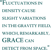
On planet Earth, we tend to think of the gravitational effect as being the same no matter where we are on the planet. We certainly don’t see variations anywhere near as dramatic as those between the Earth and the Moon. But the truth is, the Earth’s topography is highly variable with mountains, valleys, plains, and deep ocean trenches. As a consequence of this variable topography, the density of Earth’s surface varies. These fluctuations in density cause slight variations in the gravity field, which, remarkably, GRACE can detect from space. A Closer Look at the Gravity Field Although the Earth’s surface is not uniform, for the most part, the variations are constant over very long time intervals. In other words, if a mountain was at a given location last month, it’s probably going to be at that same location this month as well, and for all intents and purposes the mass of the mountain is unchanged. This means that the gravity influence of these larger features is pretty much the same over a very long time and is known as the mean (or long-term average) gravity field. There are other mass variations, however, that occur on much smaller time scales. These are mostly due to variations in water content as it cycles between the atmosphere, oceans, continents, glaciers, and polar ice caps. These shorter-term mass fluctuations contribute to what is known as the time-variable gravity field. Both the mean gravity field and the monthly maps of the time-variable gravity field are useful tools for scientists as they study the Earth’s changing climate. The mean gravity field helps scientists better understand the structure of the solid Earth and learn about ocean circulation. Likewise, scientists use time-variable gravity to study ground water fluctuations, sea ice, sea level rise, deep ocean currents, ocean bottom pressure, and ocean heat flux. next: Gravity
Anomaly Maps and The Geoid |
This famous photograph of an astronaut taking a “giant leap for mankind” demonstrates the effect of the moon’s lower gravity on a person’s weight. Because the moon is smaller than the Earth and about 60 percent as dense, the astronaut’s weight is only about one-sixth of what it would be on Earth. Although they are not as dramatic as the Earth-moon difference, slight variations in the mass and density across the Earth’s surface do create differences in Earth’s gravity field. |
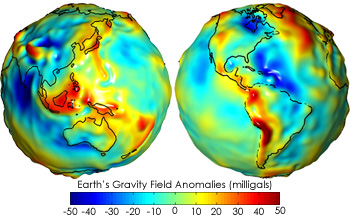
Gravity Anomaly Maps and The Geoid The Earth’s gravity field is depicted in two principal ways: gravity anomaly maps and maps of the Earth’s geoid. Gravity anomaly maps (see globe below) show how much the Earth’s
actual gravity field differs from the gravity field of a uniform, featureless
Earth surface. The anomalies highlight variations in the strength of
the gravitational force over the surface of the Earth. Gravity anomalies
are often due to unusual concentrations of mass in a region. For example,
the presence of mountain ranges will usually cause the gravitational
force to be more than it would be on a featureless planet — positive
gravity anomaly. Conversely, the presence of ocean trenches or even the
depression of the landmass that was caused by the presence of glaciers
millennia ago can cause negative gravity anomalies. |
GRACE |
||
|
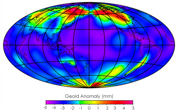
The geoid is a hypothetical Earth surface that represents the mean sea level in the absence of winds, currents, and most tides. The geoid is a useful reference surface. It defines the horizontal everywhere and gravity acts perpendicular to it. A carpenter’s level aligns itself along the geoid and a carpenter’s plumb bob points down the vertical or perpendicular to the geoid. Water will not flow in aqueducts if the pipes are perfectly aligned along the geoid. Surveyors use knowledge of the geoid and the horizontal when they lay out highways and boundaries. Producing a precise model of the geoid has proven to be a challenge. Until recently, there was no single source for producing a geoid map. Data from several dozen satellites, along with surface measurements over land and from ships at sea, had to be combined to produce a model of the gravitational field. Traditionally, the models have done a fairly good job reproducing large-scale features of the gravity field, but have fallen short when it comes to reproducing finer-scale features or accurately describing time-variable gravity effects like those associated with the hydrologic cycle. GRACE provides, for the first time, global coverage of the Earth’s
gravity field every 30
days from a single source. GRACE is already able to measure the gravity
field with a level of precision that is at least 100 times greater than
any existing measurement, and continued improvements are expected as
the mission progresses. The finer details of the geoid that have evaded
scientists for so long are on the verge of being revealed. GRACE also
gives us our best opportunity to date to study time-variable gravity
effects. As the mission progresses and more data are added to the model,
the resolution of the geoid will improve even further. |
These “gravity anomaly” maps show where models of the Earth’s gravity field based on GRACE data differ from a simplified mathematical model that assumes the Earth is perfectly smooth and featureless. Areas colored yellow, orange, or red are areas where the actual gravity field is larger than the featureless-Earth model predicts—such as the Himalayan Mountains in Central Asia (top left of the left-hand globe)—while the progressively darker shades of blue indicate places where the gravity field is less—such as the area around Hudson Bay in Canada (top center of right-hand globe). |
||
|
As the geoid map becomes more detailed, the accuracy of satellite altimetry, synthetic aperture radar interferometry, and digital terrain models covering large land and ice areas — all used in remote sensing applications and cartography — will improve. These techniques provide critical input to many scientific models used in oceanography, hydrology, geology, and related disciplines, and will be used for a variety of applications including:
This enhanced knowledge should lead to a better understanding of the forces that drive El Niño and La Niña, more accurate seasonal forecasts of Earth’s weather patterns, an ability to track the changing distribution of water resources in critically important land aquifers, and improved forecasting of natural hazards. next: The Workings
of GRACE |
The Earth’s gravity signal changes day-to-day, even minute by minute. The image above shows how the average variability in Earth’s gravity field in August 2002 compared to the yearly average of 2001. The red and pink areas show where the variation measured in August 2002 is the most different from the variation measured for the year 2001, while the blue and purple areas show where the variation measured in August 2002 is just about the same as the variation measured for the year 2001. The variability has to be accounted for using models in order to produce a mean gravity field that is useful for hydrologic applications. (Image credit: Paul Thompson / UT-CSR) |
The Workings of GRACE GRACE is different from most Earth observing satellite missions—Terra and Aqua for example—because it doesn’t carry a suite of independent scientific instruments on board. It does not make measurements of the electromagnetic energy reflected back to it from the Earth’s surface. Instead, the two GRACE satellites themselves act in unison as the primary instrument. Changes in the distance between the twin satellites are used to make gravitational field measurements.
The two identical satellites orbit one behind the other in the same orbital plane at approximate distance of 220 kilometers (137 miles). As the pair circles the Earth, areas of slightly stronger gravity (greater mass concentration) affect the lead satellite first, pulling it away from the trailiing satellite. As the satellites continue along their orbital path, the trailing satellite is pulled toward the lead satellite as it passes over the gravity anomaly. The change in distance would certainly be imperceptible to our eyes, but an extremely precise microwave ranging system on GRACE detects these minuscule changes in the distance between the satellites. A hightly accurate measuring device known as an accelerometer, located at each satellite’s center of mass, measures the non-gravitational accelerations (such as those due to atmospheric drag) so that only accelerations cased by gravity are considered. Satellite Global Positioning Syste (GPS) receivers determine the exact position of the satellite over the Earth to within a centimeter or less. Members of the GRACE science team can download all this information from the satellites, and use it to construct monthly maps of the Earth’s average gravity field during the planned five-year mission. next: Key Spacecraft
Components |
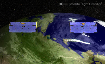
GRACE The positions of the two GRACE satellites change in response to variations in Earth’s gravity field. When the two spacecraft pass over the ocean, the distance between them is unchanged (first panel). But when the lead spacecraft encounters a change in gravity over a denser land mass (second panel), it pulls away from the trailing spacecraft, which is still over water. The lead spacecraft moves back over water (third panel), but now the trailing spacecraft changes position in response to the greater pull of gravity over the land mass. The drawings are not to scale. In reality, the GRACE satellites are spaced about 220 kilometers apart, and changes in distance between them would be undetectable by human eyes. GRACE has an onboard microwave-ranging system that makes precise, continuous measurements of the distance between the two spacecraft as they orbit the Earth. |
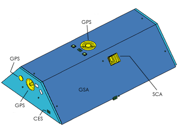
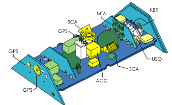
Key Spacecraft Components Now that we have an idea how GRACE works, let’s peer “under the hood” of this high-tech wonder and understand some of the component parts of GRACE. These components can be seen in the photos on pages 2 and 4; the letters following the name of each component in parentheses correspond to the labels on the diagrams below each photo.
K-band Ranging System (KBR). Provides precise (within 10 µm) measurements of the distance change between the two satellites needed to measure fluctuations in gravity. Ultra Stable Oscillator (USO). Provides frequency generation for the K-band ranging system. SuperSTAR Accelorometers (ACC). Precisely measures the non-gravitational accelerations acting on the satellite. Star Camera Assembly (SCA). Precisely determines the two satellites’ orientation by tracking them relative to the position of the stars. Coarse Earth and Sun Sensor (CES). Provides omnidirectional, reliable, and robust, but fairly coarse, Earth and Sun tracking. Used during initial acquisition and whenever GRACE operates in safe mode. Center of Mass Trim Assembly (MTA). Precisely measures the offset between the satellite’s center of mass and the “acceleration-proof” mass and adjusts center of mass as needed during the flight. Black-Jack GPS Receiver and Instrument Processing Unit (GPS). Provides digital signal processing; measures the distance change relative to the GPS satellite constellation. Globalstar Silicon Solar Cell Arrays (GSA). Covers the outer shell of the spacecraft and generates power.
next: The Future |
GRACE |
The Future GRACE builds on the heritage of the German Space Agency’s Challenging Minisatellite Payload (CHAMP) mission in the area of Earth gravity field measurements. The revolutionary new configuration for GRACE—using two satellites following one another on the same orbital track—is expected to improve the accuracy of gravity field measurements dramatically. The European Space Agency plans to launch the Gravity Field and Steady-State Ocean Circulation (GOCE) mission in 2006 as part of its Living Planet Programme. The sensor’s measurements of the gravity field will complement those made by GRACE. The science community believes that even more accurate gravity measurements may be possible in the future as new technologies are developed. One possibility involves replacing the microwave ranging system on GRACE with a laser ranging system. This would allow for even more precise distance measurements than GRACE can obtain and thereby increase the accuracy of the resulting gravity field measurements. The ESSP Program A component of NASA’s Earth Science Enterprise (ESE), Earth System Science Pathfinder (ESSP) Missions are intended to address unique, specific, highly-focused scientific issues and provide measurements required to support Earth science research. The ESSP missions are an integral part of a dynamic and versatile program consisting of multiple space flights to study Earth system science. The ESSP program is characterized by relatively low- to moderate-cost, small to medium-sized missions that are capable of being built, tested, and launched in short time intervals. These missions are capable of supporting a variety of scientific objectives related to Earth science, including the atmosphere, oceans, land surface, polar ice regions, and solid Earth. Investigations include developing and operating remote-sensing instruments and conducting research investigations using data obtained from these instruments. Subsequent launches are planned over the next few years. A Program Manager located at Goddard Space Flight Center is responsible for overall management of the ESSP Program. Each individual mission is led by a Principal Investigator (PI) who oversees all aspects of the mission, from ensuring science accuracy to making sure the mission stays on budget and on time. GRACE Management GRACE was the first ESSP mission to launch, and is a joint partnership between the National Aeronautics and Space Administration (NASA) in the United States and the Deutsches Zentrum für Luft und Raumfahrt (DLR) in Germany. The Principal Investigator is from the University of Texas Center for Space Research (UTCSR) and the Co-Principal Investigator is from the GeoForschungsZentrum (GFZ). NASA’s Jet Propulsion Laboratory (JPL) has responsibility for the Project Management of GRACE, and NASA’s Goddard Space Flight Center maintains responsibility for Mission Management. |
GRACE |