The Earth Observatory has published its last Image of the Day on this website. Please join us on our new home at science.nasa.gov/earth/earth-observatory.
Improved Monitoring | |||
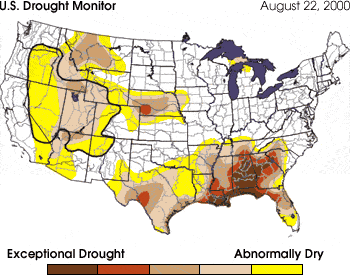
Careful monitoring of drought can ease its impacts, allowing people to take early actions that prevent harsh impacts later. Both U.S. government and private meteorologists are doing their part by producing better monitoring and forecast products. At the federal level, an inter-agency consortium involving the United States Department of Agriculture (USDA), the National Weather Service, and the National Drought Mitigation Center in Lincoln, Nebraska, began producing the Drought Monitor in 1999. The Monitor includes a weekly national map displaying dryness divided into five categories, or levels of intensity. The categories are based on readings from a number of different drought indices, giving the user a composite picture of many indicators. Drought information is updated daily through use of the thousands of observations available from cooperative weather observers. These three agencies also consult with numerous experts from other agencies and offices across the country so that the map can be tweaked to more effectively depict what is happening in the real world. The drought analysts also indicate on the map if forecast conditions over the next 2 weeks will result in significant changes to the drought situation.
Image courtesy NOAA Drought Information Center. next: Improved Forecasting
|
 Drought: the Creeping Disaster
Related Links:
| ||