The Earth Observatory has published its last Image of the Day on this website. Please join us on our new home at science.nasa.gov/earth/earth-observatory.
Drought Planning and Drought Indices | |||
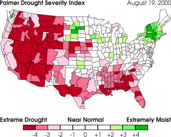
Drought planning usually involves picking or creating an index to identify and quantify anomalies. Drought indices assimilate thousands of bits of data on rainfall, temperature, snow pack, stream flow, and other water supply indicators into a comprehensible big picture that is far more useful than raw data for decision-making. A sophisticated system for measuring drought was developed by National Weather Service meteorologist Wayne Palmer in 1965. Now called the Palmer Drought Severity Index (PDSI), it uses temperature and rainfall information in a formula to determine dryness and has become the semi-official drought index. The PDSI is most effective in determining long-term drought–a matter of several months–and is not as effective with short-term forecasts (a matter of weeks). It uses a 0 as normal, and drought is shown in terms of negative numbers; for example, -2 is moderate drought, -3 is severe drought, and -4 is extreme drought. In mid August 2000, sections of many western states were in the -4 range.
Image courtesy NOAA Drought Information Center. next: Improved Monitoring
|
 Drought: the Creeping Disaster
Related Links:
| ||