
Surveying by satellite |
|||
Recently, Raxworthy has been working on new ways to explore Madagascar’s ecological treasures, but not because he is trying to avoid the challenges of field work. It’s just that he is facing an incredible challenge: providing natural resource managers in Madagascar with some guidance on where their conservation efforts would preserve the most biodiversity. |
|||
From museum records that are in some cases more than a century old, Raxworthy has known locations of some (but not all) species of chameleons in some (but not all) locations of Madagascar. He has some (but not much) money for surveying expeditions. And time? At the rate that Madagascar’s natural landscapes are being converted to human-shaped ones, there may be less time than any other resource. Knowing Where to LookCovering a lot of ground in a short amount of time is what satellite remote sensing is good for, so it makes sense for scientists to consider how they could use it for conservation and biodiversity assessments. The options, at first glance, however, appear limited. No satellite can detect a lizard from space. Not only that, says Raxworthy, but “many biologists of my generation—in their 30s and 40s—were really excited about the possibilities of remote sensing data when high-resolution data first became available back in the 70s, but we ultimately got turned off from it because of the high cost. There was a whole generation of scientists who ‘grew up’ without any experience in how to use remote sensing [for ecology studies].” |

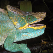
Museums have records of known locations of chameleon species such as Calumma parsonii, pictured above. Collected by biologists and naturalists during field surveys across Madagascar, some of these records are modern while others stretch back as far back as 100 years. Scientists have been working on how to use both modern and historic records to predict present-day locations and ranges of chameleons on the island. (Photograph copyright Chris Raxworthy) |
||
 |
|||
Raxworthy’s colleague Ned Horning is a scientist who has always believed that remote sensing technology could be useful for ecological niche modeling—predicting the unique locations, or niches, where species or ecological communities exist. Horning is now the Program Manager for the Geographic Information Systems (GIS) and Remote Sensing Department at the American Museum of Natural History’s Center for Biodiversity and Conservation, but he got his initial experience from 9 years at NASA’s Goddard Space Flight Center in Greenbelt, Maryland. “I started using GIS and remotely sensed data for species modeling in 1990 while I was still at NASA. We collaborated with the World Wildlife Fund in Madagascar to demonstrate how rapid survey methods [using satellite data] could be used to get a decent understanding of species distributions for conservation planning.” Once he started working for the American Museum of Natural History, he started thinking about how they could integrate satellite data with the museum’s millions of specimen collection records to advance their knowledge of species ranges, or distributions. His and Raxworthy’s interest converged on Madagascar. Specimens and Space DataThe scientists started with a scattering of chameleon location data points—the latitude and longitude points where museum records said different chameleons had been found. But a scattered collection of species occurrence points doesn’t identify a species distribution, or range. A species’ range depends on many environmental characteristics: rainfall, temperature, altitude, topography, and so on. The first thing the scientists set out to do was identify as many environmental characteristics as they could at the places where the museum records said scientists had found chameleons. |
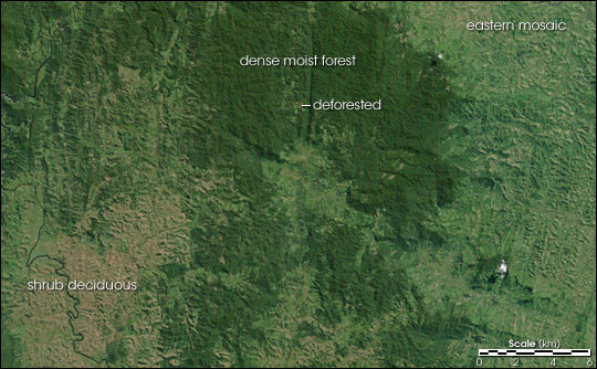
Satellite imagery allows scientists to map ecosystems and animal habitats in remote areas of Madagascar. This true-color image shows the edge of the dense moist forest in the southeastern section of the island, as well as shrub deciduous and eastern mosaic land cover types. The irregular intrusions of light regions along the edges of dark, forested land indicate deforestation. (Image by Robert Simmon, based on Landsat data provided by the UMD Global Land Cover Facility.) |
||
 |
|||
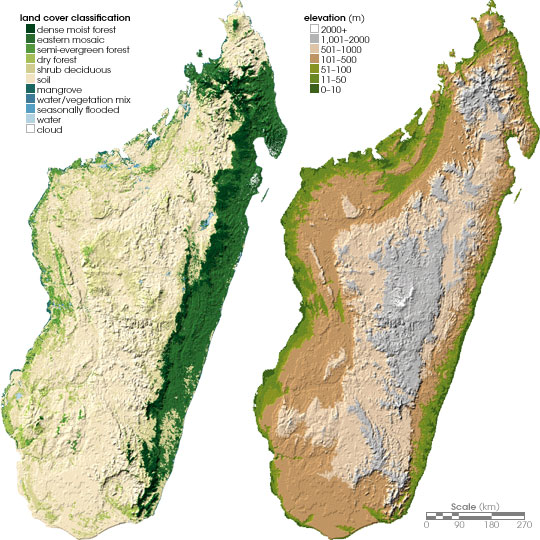
One of the most important characteristics of a habitat is what’s covering the surface—the land cover. As far as land cover was concerned, however, all that was available at the time they were starting this research, says Horning, “were some outdated land cover maps developed in the mid-1970s.” Given the rapid and profound changes in the landscape due to deforestation, agriculture, and development that had taken place in Madagascar since the 1970s, those maps wouldn’t have been very useful. Instead, Horning suggested they use new data from a sensor on NASA’s Terra satellite: the Moderate Resolution Imaging Spectroradiometer, or MODIS, for short. The MODIS data were ideal, explains Horning, because the sensor sees such a large area at once that they didn’t have to spend a lot of time stitching together lots of smaller images in order to get a complete picture of the country. The sensor’s near-daily coverage also allowed them to look at data from different seasons; being able to look at seasonal changes in vegetation helps to identify what kind of ecosystem you are seeing; the frequent coverage also helped overcome the cloudiness that regularly hides the island’s humid areas. “And of course,” adds Horning, “the fact that the data are free was nice, too.” Remote sensing provided other environmental observations for the team: topography data from NASA’s Shuttle Radar Topography Mapping Mission and precipitation observations from National Oceanic and Atmospheric Administration satellites. |
Satellite data of environmental characteristics, such as land cover derived from NASA’s Moderate Resolution Imaging Spectroradiometer (left) and elevation (right), and known chameleon locations identified by scientists during field studies, can be used to develop computer models that predict the full ranges of chameleon species. Satellites provide up-to-date data that are critical for researchers who are modelling Madagascar’s rapidly changing landscape. {Map by Robert Simmon, based on data prvided by Ned Horning, American Museum of Natural History (left), and Socioeconomic Data and Applications Center (right)} |
||