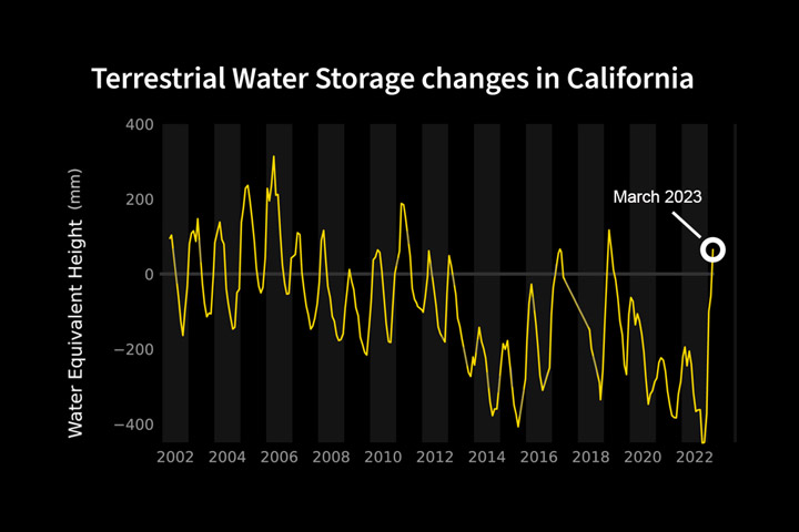
After years of intense drought and diminishing groundwater, California just saw its greatest year-over-year water gains in two decades, according to data from the Gravity Recovery and Climate Experiment Follow-On (GRACE-FO) satellite mission, a partnership between NASA and the German Research Centre for Geosciences (GFZ). This past winter’s bonanza of atmospheric rivers alleviated some of the water deficit that the state incurred during periods of drought over the last 10 years, which included the three driest years on record in California.
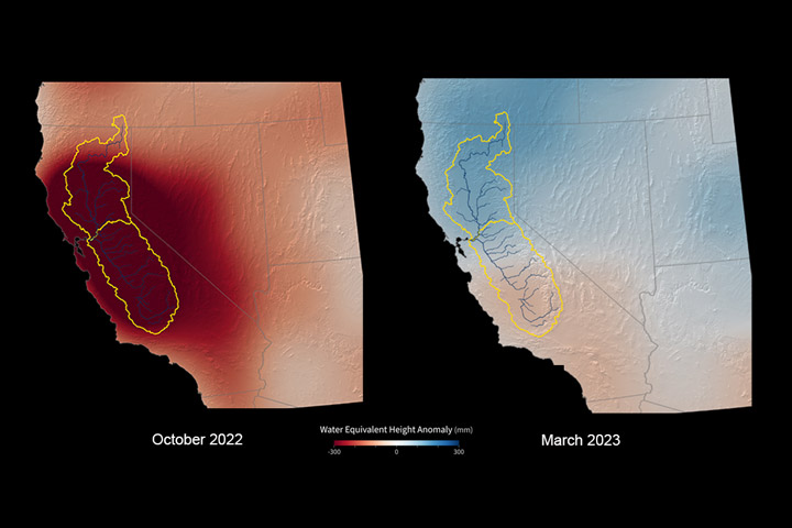
Think of the state’s Central Valley region (outlined in yellow) as a giant swimming pool: GRACE-FO measurements include all the water contained in the lakes, rivers, soil, snowpack, and underground aquifers within that region. Between October 2022 and March 2023, storms provided enough water to raise the amount of water within the “swimming pool” by about 20 inches (about 500 millimeters). That’s about twice as much as the average winter water gain since satellite-based water storage measurements began in 2002 with the first GRACE mission.
The gain in water between October 2022 and March 2023 is apparent in the maps above. Blue colors represent areas where conditions were wetter than average (relative to 2004–2010), while red colors were drier than average. The yellow line in the chart below shows the month-to-month variations in water storage for the area outlined in yellow on the maps.
While surface water basins are filling, underground stores of fresh water (aquifers) that are tapped for irrigation and other needs could take years to fully recharge. “One good winter of rain and snow won’t make up for years of extreme drought and extensive groundwater use,” said Felix Landerer, GRACE-FO project scientist at NASA’s Jet Propulsion Laboratory. The GRACE-FO team will continue to track how California’s water storage evolves through the summer after the snowpack melts and water levels in the state’s lakes, rivers, and reservoirs start to recede during drier weather.
The observations were made possible through the unique sensing approach taken by both GRACE missions. As water moves around—in the form of ocean currents, falling rain, shifting groundwater, ice, and so on—it alters the planet’s mass near the surface, which changes Earth’s gravitational pull ever so slightly. GRACE-FO measures these subtle changes, enabling researchers to estimate changes in the total volume of water in an area.
Like its predecessor, the GRACE-FO mission consists of two identical satellites that fly one behind the other. As the lead satellite flies over an area with greater mass—such as an area with more water than another region—the slight change in gravity tugs it forward, increasing the distance between the two satellites. Microwave and laser instruments aboard the spacecraft precisely measure the minute distance changes between the two, revealing details about the overall mass of water that caused those changes.
NASA/JPL-Caltech visualizations by Marit Jentoft-Nilsen, with scientific consulting by Felix W. Landerer. Story by Jane Lee/NASA JPL.
Data from winter 2022-2023 show the greatest net gain of water in nearly 22 years, but groundwater levels still suffer from years of drought.
Image of the Day for June 10, 2023
View more Images of the Day:

alert message