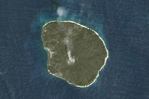
When a volcano in the South Pacific Kingdom of Tonga began erupting in late-December 2021 and then violently exploded in mid-January 2022, NASA scientist Jim Garvin and colleagues were unusually well positioned to study the events. Ever since new land rose above the water surface in 2015 and joined two existing islands, Garvin and an international team of researchers have been monitoring changes there. The team used a combination of satellite observations and surface-based geophysical surveys to track the evolution of the rapidly changing piece of Earth.
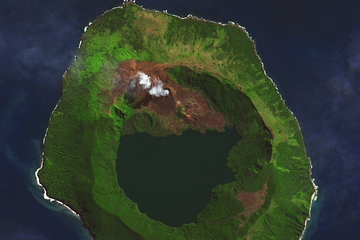
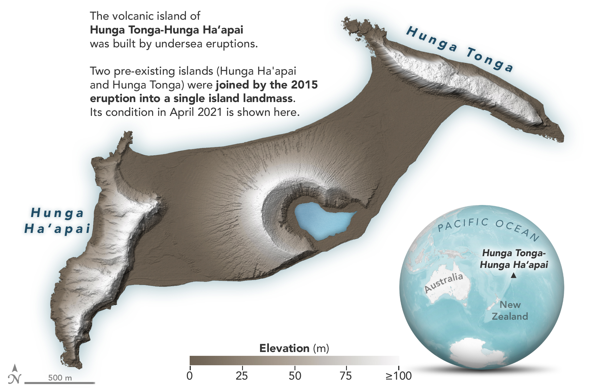
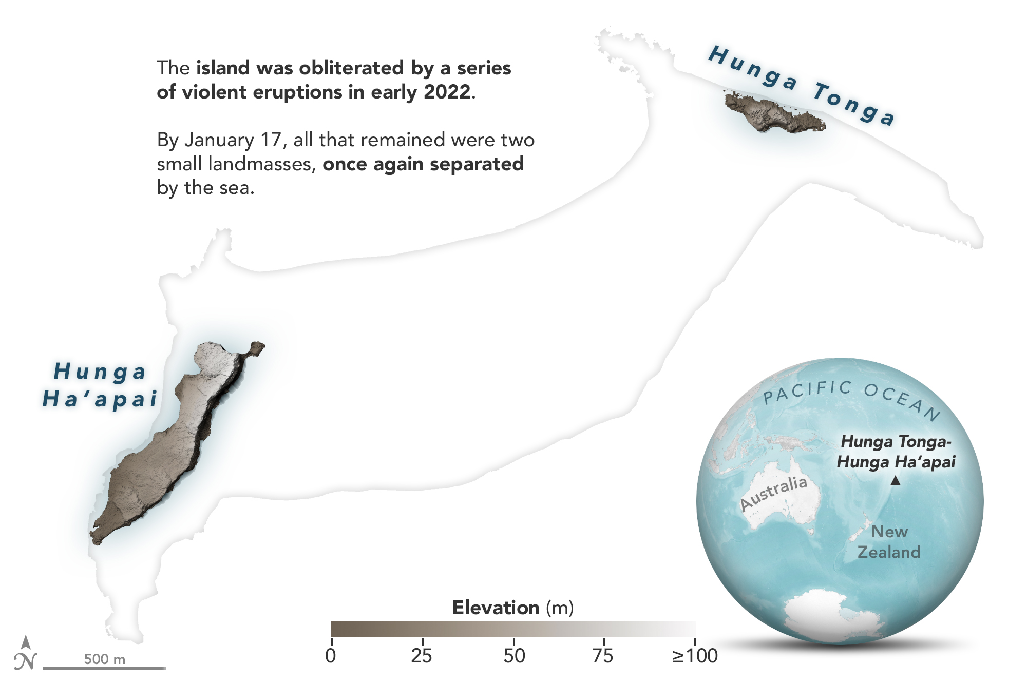
The digital elevation maps above and below show the dramatic changes at Hunga Tonga-Hunga Ha‘apai, the uppermost part of a large underwater volcano. It rises 1.8 kilometers (1.1 miles) from the seafloor, stretches 20 kilometers (12 miles) across, and is topped by a submarine caldera 5 kilometers in diameter. The island is part of the rim of the Hunga Caldera and was the only part of the edifice that stood above water.
Now all of the new land is gone, along with large chunks of the two older islands.
“This is a preliminary estimate, but we think the amount of energy released by the eruption was equivalent to somewhere between 4 to 18 megatons of TNT,” said Garvin, chief scientist at NASA’s Goddard Space Flight Center. “That number is based on how much was removed, how resistant the rock was, and how high the eruption cloud was blown into the atmosphere at a range of velocities.” The blast released hundreds of times the equivalent mechanical energy of the Hiroshima nuclear explosion. For comparison, scientists estimate Mount St. Helens exploded in 1980 with 24 megatons and Krakatoa burst in 1883 with 200 megatons of energy.
Garvin and NASA colleague Dan Slayback worked with several researchers to develop detailed maps of Hunga Tonga-Hunga Ha‘apai above and below the water line. They used high-resolution radar from the Canadian Space Agency’s RADARSAT Constellation Mission, optical observations from the commercial satellite company Maxar, and altimetry from NASA’s ICESat-2 mission. They also used sonar-based bathymetry data collected by the Schmidt Ocean Institute, in partnership with NASA and Columbia University.
For the past six years, researchers from NASA, Columbia, the Tongan Geological Service, and the Sea Education Association worked together to determine how the young terrain was eroding due to the ongoing churn of waves and occasional battering by tropical cyclones. They also noted how wildlife—various types of shrubs, grasses, insects, and birds—had moved from the lush ecosystems of Hunga Tonga and Hunga Ha‘apai and colonized the more barren landscapes of the newer land.
Things changed dramatically in January. For the first few weeks of 2022, the volcanic activity seemed typical enough, with intermittent, small explosions of tephra, ash, steam, and other volcanic gases as magma and seawater interacted at a vent near the middle of the island. The ongoing Surtseyan eruptions were reshaping the landscape and enlarging the island by adding new deposits of ash and tuff to the growing volcanic cone.
“By early January, our data showed the island had expanded by about 60 percent compared to before the December activity started,” said Garvin. “The whole island had been completely covered by a tenth of cubic kilometer of new ash. All of this was pretty normal, expected behavior, and very exciting to our team.”
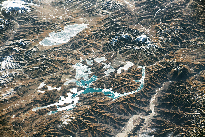
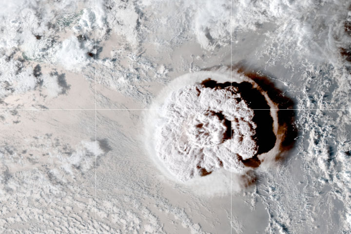
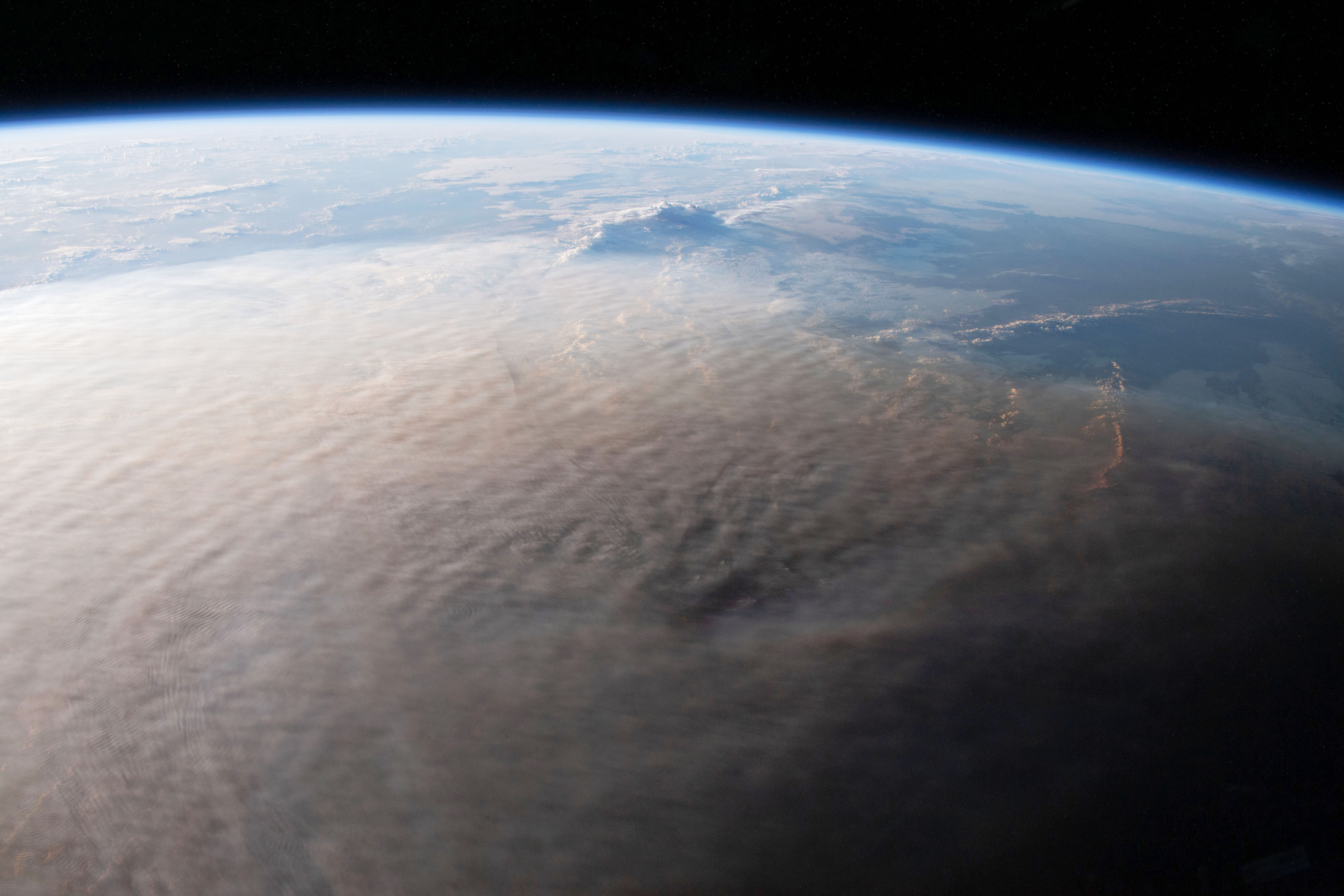
But on January 13-14, an unusually powerful set of blasts sent ash surging into the stratosphere. Then explosions on January 15 launched material as high as 40 kilometers (25 miles) in altitude and possibly as high as 50 kilometers, blanketing nearby islands with ash and triggering destructive tsunami waves. An astronaut aboard the International Space Station took this photo of ash over the South Pacific.
Most Surtseyan style eruptions involve a relatively small amount of water coming into contact with magma. “If there’s just a little water trickling into the magma, it’s like water hitting a hot frying pan. You get a flash of steam and the water burns burn off quickly,” explained Garvin. “What happened on the 15th was really different. We don’t know why — because we don’t have any seismometers on Hunga Tonga-Hunga Ha‘apai — but something must have weakened the hard rock in the foundation and caused a partial collapse of the caldera’s northern rim. Think of that as the bottom of the pan dropping out, allowing huge amounts of water to rush into an underground magma chamber at very high temperature.”
The temperature or magma usually exceeds 1000 degrees Celsius; seawater is closer to 20°C. The mixing of the two can be incredibly explosive, particularly in the confined space of a magma chamber. “This was not your standard Surtseyan eruption because of the large amount of water that had to be involved,” said Garvin. “In fact, some of my colleagues in volcanology think this type of event deserves its own designation. For now, we’re unofficially calling it an ‘ultra Surtseyan’ eruption.”
For a geologist like Garvin, watching the birth and evolution of a “Surtseyan island” like this is fascinating, partly because there have not been many other modern examples. Aside from Surtsey—which formed near Iceland in 1963 to 1967 and still exists more than a half-century later—most new Surtseyan islands get eroded away within a few months or years.
What also interests Garvin about these islands is what they may teach us about Mars. “Small volcanic islands, freshly made, evolving rapidly, are windows in the role of surface waters on Mars and how they may have affected similar small volcanic landforms,” he said. “We actually see fields of similar-looking features on Mars in several regions.”
NASA Earth Observatory images by Joshua Stevens, using elevation data courtesy of Dan Slayback/NASA/GSFC. Astronaut photograph ISS066-E-117965 was acquired on January 16, 2022, with a Nikon D5 digital camera using a focal length of 50 millimeters. NASA ground photo by Dan Slayback. Story by Adam Voiland.