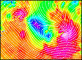

The SeaWinds scatterometer aboard NASA’s QuikSCAT satellite collected the data used to create this colorful image of Cyclone Olaf churing in the South Pacific on February 16, 2005. The colored background shows the near-surface wind speeds at 2.5-kilometer resolution. The strongest winds, shown in purple, are at the center of the storm, with gradually weakening winds forming rings around the center. The black barbs indicate wind speed and direction at QuikSCAT’s nominal, 25-kilometer resolution; white barbs indicate areas of heavy rain.
NASA’s Quick Scatterometer (QuikSCAT) spacecraft was launched from Vandenberg Air Force Base, California, on June 19, 1999. QuikScat carries the SeaWinds scatterometer, a specialized microwave radar that measures near-surface wind speed and direction under all weather and cloud conditions over the Earth’s oceans.
NASA image courtesy of the QuikSCAT Science Team at the Jet Propulsion Laboratory.
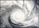
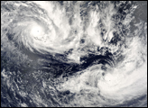
This MODIS image shows Cyclones Olaf and Nancy on February 16, 2005, one day before Olaf passed over American Samoa as a Category 5 storm.


