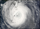
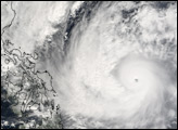
The MODIS instrument onboard NASA's Terra satellite captured this true-color image of Typhoon Nanmadol at 02:00 UTC on December 1, 2004. At the time this image was taken Nanmadol was located approximately 390 miles west-northwest of Yap and was moving at a brisk 28 mph towards the west-northwest. Maximum sustained winds were near 120 mph with higher gusts to 150 mph.
NASA image created by Jesse Allen, Earth Observatory, using data obtained from the MODIS Rapid Response team.
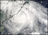
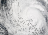
The fourth tropical storm to strike the Philippines in two weeks moved ashore on December 2, 2004. The TRMM satellite captured this image of the weakening storm after it moved across Luzon.

alert message