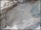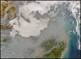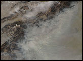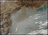

In east-central China, the broad coastal plain through which the Yellow River drains out to Bo Hai is surrounded in an arc by a landscape of ridges and valleys. In this Moderate Resolution Imaging Spectroradiometer (MODIS) image from the sensor on the Aqua satellite on November 17, 2004, the coastal plain takes up most of the scene. Grayish haze spreads across the coastal plain, and it fills valleys in the west, highlighting the topography. For example, the south-flowing Fen River at left center edge cuts a broad swath into the Taiyue Shan (Shan means “mountains” in Chinese), and haze has settled into the low-lying terrain. The haze flows off the continent and out over Bo Hai (top right) and the Yellow Sea (center right). The haze is likely a combination of several factors: emissions from the country's coal-dominated electricity production, smoke from home heating fires, and vehicle exhaust and other urban pollution from the region’s large cities, such as Beijing and Tianjin.
NASA image courtesy the MODIS Rapid Response Team, NASA-Goddard Space Flight Center
Incomplete burning of carbon-based fuels like coal and wood leads to a build-up of haze in eastern China, where mountains and weather patterns can trap it for days at a time. This Terra MODIS image is a comparison of a hazy day and a relatively clear day in February 2005.


