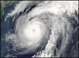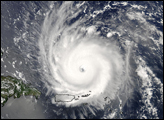
The MODIS instrument onboard NASA's Terra spacecraft captured this true-color image of Hurricane Alex on August 4, 2004 at 11:00 A.M. EDT. At the time this image was taken Alex was located approximately 400 miles east-northeast of Cape Hatteras, North Carolina and had maximum sustained winds of 85 mph. Alex was moving towards the east-northeast at 20 mph and that motion was expected to continue over the next 24 hours.
The MODIS Rapid Response System provides this image at additional resolutions and formats.
Image courtesy Jacques Descloitres, MODIS Land Rapid Response Team at NASA GSFC.
alert message