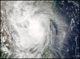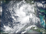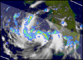

The Tropical Rainfall Measuring Mission (TRMM) satellite captured these images of Tropical Storm Erika just as it was getting organized in the eastern Gulf of Mexico. The images were taken at 4:15 pm EDT (20:15 UTC) on the 14th of August, 2003. At the time Erika was not yet a named storm but was named less than an hour after these images were captured. Erika had maximum sustained winds of 40 mph.
Erika formed from an easterly wave disturbance after moving from the Bahamas across the Florida penisula. Over the open warm waters of the Gulf, the system began to gain strength and become better organized in a relatively low wind-shear environment. The image shows a top-down view of the storm. Rainfall rates from the TRMM Precipitation Radar (PR) (in the inner swath) and the TRMM Microwave Imager (TMI) (outer swath) are overlayed on TRMM Visible Infrared Scanner (VIRS) data (white areas).
This combination shows bands of convection feeding into the storm. The center is open and does not yet have a well-defined eye. The blue, green, yellow and red areas indicate increasing rainfall intesity. At the time of this image, the storm was moving quickly to the west at 21 mph under the influence of high pressure to the north.
TRMM is a joint mission between NASA and the Japanese space agency NASDA.
Images produced by Hal Pierce (SSAI/NASA GSFC) and caption by Steve Lang (SSAI/NASA GSFC).
After plowing across southern Florida on Thursday, August 14, a tropical depression became Tropical Storm Erika in the Gulf of Mexico. The storm was approaching Texas on August 15, 2003.


