

In May and June 2012, Robert Anemone was doing what he usually does in early summer. The professor from Western Michigan University was preparing to spend several weeks working outdoors in Wyoming, digging for fossils in the Great Divide Basin.
But the summer of 2012 would be different. Instead of digging in his usual places for old bones and teeth, Anemone was planning to spend time in some new locations—sites handed to him by an artificial intelligence he helped create.
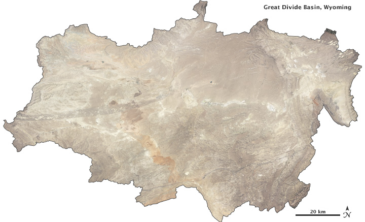
True-color satellite image of the Great Divide Basin, Wyoming. (NASA Earth Observatory image by Robert Simmon, using data from the USGS Earth Explorer and Wyoming Geographic Science Center.)
Anemone started down this unusual path thanks to a spur-of-the-moment decision in 2009. He had been digging in the Great Divide Basin for 13 years, always driving to his dig sites on the same dirt roads. One day, for no particular reason, he decided to take a different route. Along the way, a new outcrop of rock caught his eye. Thinking it looked promising—“tasty” as he likes to say—he stopped the truck and started looking for fossils. That tasty outcrop proved to be the most productive site his research group has found in all of his years digging in the Great Divide.
“That was kind of a seminal moment for me,” Anemone says. “That’s when I realized just how much of this is based purely on luck.”
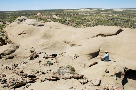
This expanse of bare rock—Tim’s Confessions—is the richest fossil site Robert Anemone’s team has ever discovered in the Great Divide Basin. In the summer of 2009, they found 500 mammal jaws and 4,000 teeth and skeletal pieces. (Photograph ©2009 Robert Anemone, University of Western Michigan.)
Most vertebrate paleontologists today find fossils the same way their predecessors did in the nineteenth century. They walk the landscape looking for big fossils; sometimes they crawl on the surface looking for little ones. Figuring out which sites to visit is a matter of reading the scientific literature to see where good fossils have been found and reading the geology to discern where fossils might be buried.
Although fossils can be found in almost any type of landscape, badlands—which have scarce vegetation but plenty of bare rock—are among the most fruitful sites. But badlands cover big areas, and inspecting every outcrop in these hot, dry regions is not practical.
After stumbling upon his best fossil site by accident, Anemone decided it was time to improve his odds of success. The key was not sharpening his eyesight on the ground, but using eyes in the sky.
To improve his odds, Anemone turned to Charles “Jay” Emerson, a geography professor who is also based at Western Michigan University. Emerson specializes in interpreting satellite images, including those from the Enhanced Thematic Mapper Plus (ETM+) on the Landsat 7 satellite.
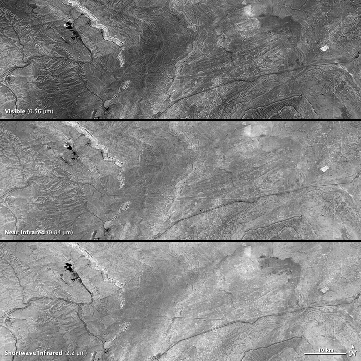
Since 1972, Landsat satellites have observed our planet’s forests, deserts, cities, farms—and badlands. The few paleontologists who have been willing to take advantage of the technology have benefited because, even though Landsat can’t see fossils, it can see the kinds of rocks where they are likely to reside. This is partly because Landsat can see wavelengths of light that human eyes can’t detect.
Anything in the universe that is warmer than absolute zero (-273 degrees Celsius) emits electromagnetic radiation. All of that energy—from gamma rays to X rays to radio waves—is referred to as the electromagnetic spectrum. “The retina of the human eye responds to a limited portion of the electromagnetic spectrum,” Emerson explains. The radiation just beyond the human range of vision includes ultraviolet light (shorter wavelengths than blue light) and infrared light (longer than red light).
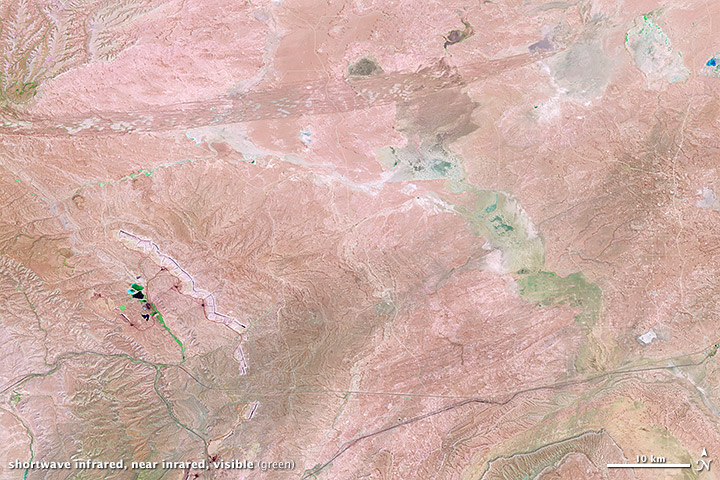
Combinations of different wavelengths of light—including invisible wavelengths—reveal different properties of the Earth’s surface. (NASA image by Robert Simmon, using Landsat data.)
In addition to blue, green, and red wavelengths, the ETM+ sensor on Landsat 7 can detect infrared radiation, which enables it to distinguish—sometimes better than human eyes—between different rock types. The minerals that make up Earth’s rock layers have distinct chemical compositions and crystalline structures, and tend to reflect different wavelengths in unique ways. The differences occur in visible and infrared wavelengths, or what remote sensing scientists refer to as spectral bands. “Using the seven discrete spectral bands in the Landsat ETM+ sensor,” Emerson says, “image analysts can use different combinations of reflectance to identify different land cover materials.”
Anemone and Emerson aren’t the first scientists to turn to remote sensing for fossil hunting. One of their colleagues at the Denver Museum of Nature and Science, Richard Stucky, started working with NASA to explore Landsat’s potential in the mid-1980s. Stucky and colleagues produced a series of “false terrain” images designed to show contrast between different rock types.
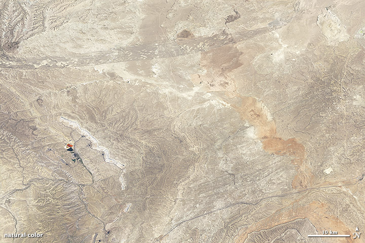
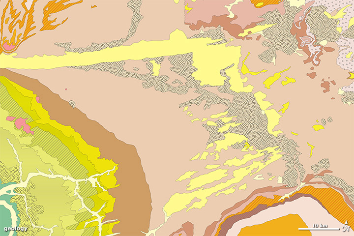
Geology is often visible from space, especially in areas with little to no vegetation, like Wyoming badlands. Compare this natural-color satellite image (top) with a geologic map (lower), compiled from surveys on the ground. Each color represents a different land surface, including different rock types, sand dunes, and deposits from dried-up lakes. (NASA image by Robert Simmon, using Landsat data. Map adapted from the Geologic Map of Wyoming.)
“Suppose you have a landscape with rock layers from different geologic periods and very clear separations—what we call ‘unconformities’—between them,” Stucky says. “And suppose you know that one rock layer has high silica content and another has high clay content.” By acquiring satellite images of the unconformities and then confirming the rock types through on-site human inspection, Stucky and other researchers thought they could create computer software to distinguish between the rocks.
In the early days, Stucky had doubts about whether the approach would work. “I remember one image that showed a black dot in the middle of this big exposure, and we couldn’t imagine what it might be,” he says. He was worried that Landsat wasn’t showing the land surface accurately, and if so, it wouldn’t be much use in locating fossil-rich sites. “We went out and looked, and it turned out to be a trash dump. Landsat picked up on the iron content in the abandoned cars.” The ground-truth exercise allayed Stucky’s early fears.
Detecting an iron-rich trash dump isn’t the same as distinguishing between different types of rock, but it did show that Landsat sensors could take advantage of the different ways that minerals reflect light. Stucky was impressed with the early results. “They weren’t perfect, but they were pretty good. It was a promising start.”
In the years since Stucky first explored Landsat’s potential, new computer processing techniques have added to the paleontologist’s toolbox. As Anemone and Emerson examine the Great Divide Basin, they don’t just look at a few satellite images. They have taught their computers to analyze hundreds of images.
Inspired by nerve cells (neurons) in the human brain, artificial neural networks tackle complex problems by dividing them into smaller pieces. The networks consist of nodes—which receive inputs, process them, and produce outputs—and connections. Connections pass along the results to subsequent nodes. Not all nodes perform equally important functions, so the connections between nodes assign varying values and priorities to the information they channel.
The neural network assembled by Anemone and Emerson consists of input nodes, hidden nodes, and output nodes. The input nodes are the different spectral bands from Landsat ETM+; the hidden nodes handle the inner workings of the network; and the output nodes are the different types of land cover, including forests, wetlands, sand dunes, and known fossil sites.
But Anemone and Emerson don’t just want their computer network to calculate values. They want it to “learn” how to distinguish between sites that could hold fossils versus sites that would not. To achieve this, they used a feature of neural networks known as back-propagation.
Neural nodes typically compute results and send them forward through the network. “Training” a network means giving it examples of the outputs that it should produce. The discrepancies between what the network produces and what the trainer wants are considered errors. So while positive values travel forward through the system, errors travel backward, showing the computer its mistakes. Computer “trainers” repeat this process until the network learns how to compute the right results.
So Anemone and Emerson had to teach the computer how to use image-analysis software to do what they wanted. The lesson plan included satellite images of the Great Divide Basin.
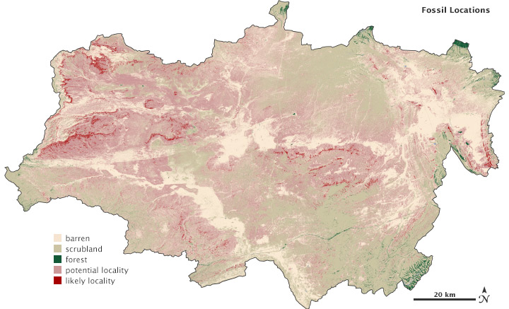
Like the digital family snapshots you can view on your computer, satellite images are composed of pixels arranged in columns and rows like tiny tiles. As Anemone and Emerson analyzed satellite images, they “tagged” pixels that corresponded with sites they knew to be fossil rich from earlier work in the basin. Through a process of iteration, Anemone and Emerson fed the computer fossil-rich and fossil-poor pixels and showed the computer its errors. The process required more than 200 iterations to teach the computer to separate land cover types into classes: barren, scrubland, forest, wetland, and promising fossil beds.
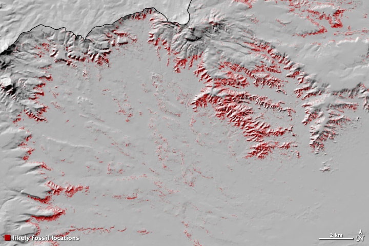
The best fossil sites are on steep slopes, where erosion exposes multiple layers of rock. (Map adapted from Anemone, et al., 2011.)
Then the moment of truth arrived: they wanted the computer network to predict which pixels were likely to contain fossils. They fed it satellite images of the Great Divide Basin that it had not analyzed before. The computer accurately identified nearly 80 percent of the pixels known to contain fossil sites.
Next, they fed the computer some imagery from the nearby Bison Basin to see if it could identify fossil-rich sites in a different landscape. They got a list of targets from Chris Beard of the Carnegie Museum of Natural History. The network found all three fossil sites that Beard had indicated.
But to their surprise, the network also identified a fourth site. It turned out to be a fossil bed that Beard knew from his own field work but hadn’t told Anemone and Emerson about.
Training a neural network is time consuming and sometimes tedious, so why bother? Why not just analyze the satellite images with human eyes? As Emerson points out, their research team would have to examine images that contain more than 52 million pixels in different spectral bands and different dimensions. It is about as practical as surveying the entire basin on foot.
When Anemone headed back to Wyoming in July 2012, he didn’t set out on his usual routes or follow his usual routines. Instead, he used his new data, gathering coordinates for several areas where the neural network predicted fossils. He also had a new companion for the fieldwork.
Emerson, who has spent much of his career analyzing images from an office, decided to go into the badlands, too. Characterizing himself as a “newbie” in fieldwork, he wanted to see with his own eyes the sites that he helped find with the neural network. If on-site examinations could show that fossils were more prevalent in the areas identified by the satellite, then he would consider the project a success.
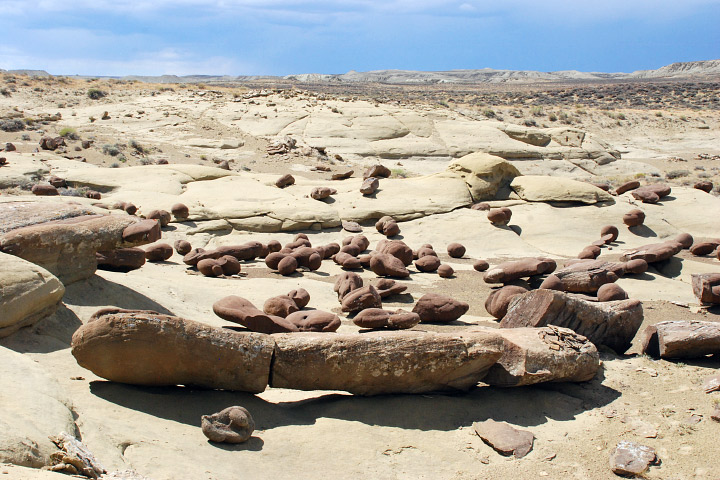
With the aid of their satellite- and neural network-derived maps, Anemone’s team discovered a new fossil location in the summer of 2012. Relatively flat and far from roads, he would not have found the site searching from the ground. (Photograph ©2012 Robert Anemone.)
“Jay picked some areas from the predictive model that showed up with a very high positive probability,” said Anemone after returning from the field. “We programmed those into our hand-held GPSs and went out to see what we could find. A couple of interesting things happened.”
The first surprise came when the satellite analysis exposed a problem with old geologic maps. Paleontologists working in Wyoming frequently encounter two geological formations: the Green River and the Wasatch. The formations are roughly the same age and contain fossils from the Eocene Epoch, an unusually warm period in Earth’s history about 56 to 34 million years ago. But the two formations were created in different environments.
Anemone, Emerson, and their team first visited Luman Rim, which geological maps consider part of the Wasatch Formation. “Wasatch was deposited along rivers and streams,” Anemone explained. He gives the example of a point bar—a crescent-shaped feature that occurs along the inside bend of a meandering river. “Things fall out of sediment as the river slows down. Sandbars get formed and fossils get deposited.” Including mammal fossils, which Anemone and his team wanted to collect.
But their prospective bed was not what they expected. “We found a bunch of fossils, but not very many mammals,” Anemone said. Instead the team found crocodiles, turtles, and fish. They found the kinds of fossils a paleontologist would expect to find in an old lakebed like the Green River Formation.
“As we spent some time in this area and looked at the geology, we realized it had been mapped incorrectly,” said Anemone. “It is not Wasatch Formation; it’s Green River. So our model brought us to a place where there were sandstones, but they were in the wrong formation.”
The second interesting development was proof of the neural network’s skill in uncovering brand new fossil sites. After Luman Rim, Anemone and Emerson visited an area they had never seen before, but that the satellite image analysis had flagged as promising.
“We parked about a mile and a half away and walked through sagebrush-covered, flat-lying, recent sediments—not the kind of place where we would expect to find fossils,” Anemone recalled. “But our GPS eventually brought us to a beautiful, big sort of sunken sandstone exposure. It was in the middle of nowhere. We never would have found this site the old way. It didn’t look promising on the maps, and it was pretty far from the road.” This new site wasn’t as productive as the tasty one they discovered in 2009, but it did yield mammal fossils from the Eocene Epoch, just as he had hoped. “In terms of the way the neural network performed, we were extremely encouraged.”
When they initially planned the field season, Anemone and Emerson thought they would spend about half of their time visiting sites that were predicted to have few, if any fossils. They planned to scour the surface of these low-probability sites, making sure that the neural network not only identified fossil-rich sites, but also fossil-poor sites. But once in the field, they found the rich sites too tempting to leave. Anemone didn’t regret the decision as he learned, right before departing for the field in July 2012, that he would be funded for future expeditions.
“The preliminary success shows that our model is picking up on something that is working for us,” Anemone notes. He hopes that the analysis technique may help not only with his usual North American sites, but also with fossil hominid sites in both East and South Africa, where he has also done research.
As for convincing fellow paleontologists to adopt the satellite approach, Anemone is less sure of success. “The majority of paleontologists still find their fossils the old-fashioned way,” he says. That approach is mostly: “You’re either lucky or you’re not.” But the challenges for paleontologists to make the most of their limited time and money for fieldwork may spur more of them to adopt more efficient techniques.
“This approach saves the time and hassle of staging a 10- to 15-person crew in the field, where you have to carry your food and shelter and where you are making good time if you’re driving 10 miles per hour,” Anemone says. “This new approach won’t guarantee results, but it sure helps you prioritize your time in the field, instead of just relying on a hunch.”
“Even if it doesn’t guarantee results,” Emerson adds, “it can at least stack the deck in your favor.”