

Nyamuragira Volcano (also known as Nyamulagira), in eastern Democratic Republic of the Congo, ranks among Africa’s most active volcanoes. After a month of unrest, Nyamuragira erupted on November 27, 2006, and scientists at the nearby Goma Volcano Observatory were concerned that the local population could be in danger. |
|||
 | |||
They had good reason to worry; in January 2002, neighboring Nyiragongo Volcano had erupted, sending a river of molten rock through the town of Goma and into nearby Lake Kivu. According to some estimates, that disaster had killed more than a hundred people and displaced a quarter million. |
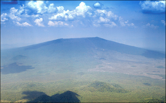
Nyamuragira Volcano rises up from the Western Rift Valley near the border of Democratic Republic of the Congo and Rwanda. The 3,053-meter volcano erupted most recently in November 2006. (Photograph ©2006 Tom Pfeiffer, Volcano Discovery.) | ||
 | |||
At the onset of the November 2006 eruption, volcanologists watching the distant glow in the nighttime sky knew that Nyamuragira produced fast-flowing lava. If it flowed very far, it might reach the nearby town of Sake, perhaps mimicking the 2002 nightmare. Years of civil war, however, had left the country with lingering strife and few disaster-response resources. To reach the volcano, scientists would have had to risk not just lava but sniper fire. |
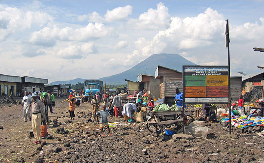
Nyamuragira’s neighbor, Nyiragongo, erupted in 2002, sending lava through the streets of Goma. The eruption killed roughly 50 people, and thousands remained displaced years later. (Photograph ©2006 Tom Schaul, EAUasis.) | ||
 | |||
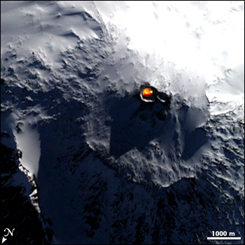
On December 1, 2006, the international science community received an appeal for assistance from the scientists at the Goma Observatory asking for any satellite imagery that could help them safely monitor the situation. One of the scientists who fielded this appeal was Ashley Davies, a research scientist at NASA’s Jet Propulsion Laboratory (JPL). Davies is part of NASA’s Volcano Sensor Web, an experimental artificial intelligence (AI) project that links orbiting and ground-based volcanic sensors with NASA’s Earth Observing-1 satellite. When the satellite receives an alert of a volcanic trouble spot, it can change its data collection and transmission plans accordingly, without waiting for a human command. The Sensor Web is an offshoot of the lab’s Autonomous Sciencecraft Experiment, a broader effort to test advanced software and AI technology that could network space exploration assets—satellites, orbiters, and rovers—and make them more self-directed. In 2004, the Earth Observing-1 (EO-1) satellite had first demonstrated its abilities by detecting and self-directing observations of an eruption of remote Erebus Volcano in Antarctica and delivering data to scientists within hours. “It worked perfectly,” Davies recalls, “although human lives weren’t at stake in that situation.” |
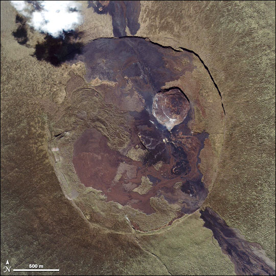
Nyamuragira is among the world’s most active volcanoes, erupting every few years for at least the past century. Recent lava flows (within a decade or two) spilled out of the volcano’s caldera to the north and southeast, replacing green vegetation with barren black and brown rock. The November–December 2006 eruption occurred on the volcano’s lower slopes, southeast of the summit. This image from the Ikonos satellite was taken on July 14, 2005. (Image ©2005 Geoeye.) | ||
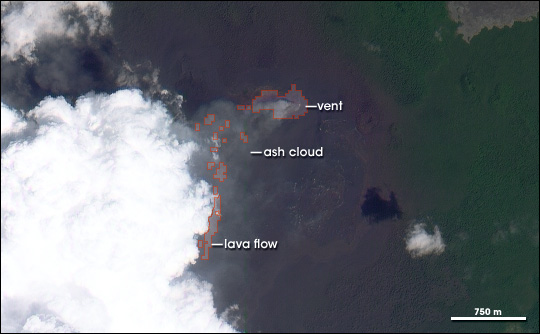
In contrast, when Nyamuragira erupted in late 2006, Davies understood that human lives could be in jeopardy. “I immediately picked up the phone and started to do the human thing and call the person who manually handles spacecraft ops for EO-1 to re-task it,” he says. “And then I noticed this email from the sensor web system. The planning software at JPL had picked up an alert originating from the Volcanic Ash Advisory Center in Toulouse [France], and had already re-tasked the spacecraft to get the data.” A step ahead of him, the sensor web had given EO-1 new orders to observe Nyamuragira Volcano at the next available opportunity, on December 4, 2006. The system transmitted a preview of the data to JPL on December 4, showing the intense thermal emission characteristic of ongoing volcanic activity. Complete high-resolution images and thermal data pinpointing the location of vent and lava flows arrived on December 5. By this time, EO-1 had re-tasked itself to obtain more data on December 7. |
On May 7, 2004, the EO-1 satellite detected heat emission from the Erebus Volcano lava lake, alerted scientists on the ground, and automatically rescheduled the satellite to obtain more observations. This image combines nighttime thermal data (yellow and orange) of Erebus' lava lake with a photo-like image of the volcano. (Image courtesy NASA/JPL.) | ||
 | |||
The December 4 data led scientists to revise their prediction of where the lava would flow. Based on the best estimate of the vent location from staff at the Goma Observatory, models run by geologist Paolo Papale and his colleagues at the L’Istituto Nazionale di Geofisica e Volcanologia (INGV) in Italy initially predicted that lava would flow both to the east and to the southwest, toward the town of Sake. The estimate for the vent location, however, was off by about 2 kilometers. |
The EO-1 satellite viewed Nyamuragira on December 4. The satellite's Advanced Land Imager collected this photo-like image and detected shortwave-infrared energy emitted from the hot lava. The Volcano Sensor Web was a step ahead of Davies in tracking this event, automatically reacting to volcanic ash reports and re-tasking EO-1 to observe the volcano. (NASA image by Robert Simmon, based on data from EO-1.) | ||
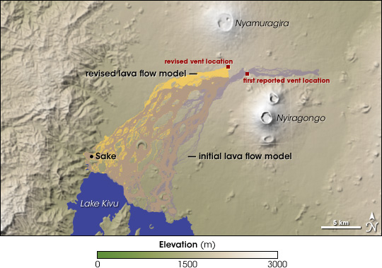 | |||
Two kilometers may not seem like much, but given fast-moving lava and hilly terrain, even a distance that small matters. When EO-1 established a different lava vent position, the modelers revised their predictions, calculating that all of the lava would flow southwest, increasing the probability that it would cut across a major road and reach Sake. “If the eruption had been bigger, it could have been catastrophic for Sake. In fact, the lava never got that far,” Davies says, “but this was a pretty quick data delivery, and it enabled the ‘boots on the ground’ to plan accordingly. I don’t know if this actually saved lives, but it definitely allowed re-targeting of resources away from the eastern side of the volcano.” |
Initial estimates of the vent location led modelers to predict that the lava could pose a threat to areas both east and southwest of Nyamuragira. When EO-1 pinpointed the actual vent location, the updated models predicted the entire flow would head southwest, increasing the chance it would reach the city of Sake. (NASA image by Jesse Allen, based on flow data from L'Istituto Nazionale di Geofisica e Vulcanologia and elevation data from the Shuttle Radar Topography Mission.) | ||