 | |||
A typical summer day at NASA Goddard Space Flight Center in Greenbelt, Maryland, dawns clear, warm, and sticky-humid, with the promise of misery by mid-day. As it climbs higher in the sky, the Sun swims through the thin haze generated by thousands of automobiles, and by the time it has dropped past its zenith, it is joined by downy piles of clouds. From an office at Goddard, the light streaming in through the window begins to dim as the clouds pile up, but that can be ignored until a distant rumble shakes the sky. By now it is late afternoon, and the office hallways are suddenly busy as people scramble to leave, hoping to reach home before Washington, D.C., traffic grinds to a halt in the sudden downpour. All of this Dr. Marshall Shepherd, an Associate Professor of Atmospheric Sciences and Geography at the University of Georgia, observed summer after summer while studying weather and climate at NASA, but while he might have sometimes worried about what rain might do to the city—water puddling on the road or overwhelming storm drains near his house—his real concern was what the city was doing to the rain. |
Title image copyright Kevin Walter. | ||
“Cities impact rainfall and can create their own rain and storms,” Shepherd explains. Though the meteorologist and climate scientist noticed the thundershowers that frequently capped off a summer day in the Washington-Baltimore region, he wasn’t aware that the cities might be influencing the rain until he noticed heavy rainfall around cities in satellite data. Reviewing the work of other scientists to determine what caused the anomaly, he learned that scientists suspected that cities were causing more rain to fall, but the connection was far from definite. He came across many theories about how cities might influence rain, but discovered that the exact process remained unknown. |
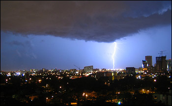
Evening storms frequently strike southern cities in the summer, bringing thunder, lightning, and heavy rain. The confluence of cities and storms may not be a coincidence: more rain falls downwind of some major urban areas than in the surrounding countryside. Satellite measurements and computer models are helping scientists understand why. (Photograph copyright Eugenia y Julian.) | ||
Shepherd realized that figuring out if and how cities affect rainfall was more than just an interesting scientific challenge. If the connection was real, weather forecasting, hydrologic, and climate models would need to take city-induced rain into account when warning people about potential flooding rains, storms, and even future climate change. It was clear to Shepherd that the problem was only going to get worse: as cities around the world continued to grow, they would be able to change weather patterns on an increasingly larger scale. Shepherd believed NASA’s fleet of Earth-observing satellites could help him understand how cities influence rain. Previous work relied primarily on field experiments around one or a few cities. Satellite data provided a way to look at many cities under varying conditions. Shepherd decided to see if NASA satellites could confirm that more rain falls around cities in general, and then take a more detailed look at individual cities to see what the satellite data could tell him about how the city influenced rain. Ultimately, Shepherd hoped he and others could use the data to generate computer models that would provide insight into how cities influence rain today and how their influence might change in the future. Discovering Urban RainWhen Shepherd first started studying satellite rainfall data, he wasn’t interested in urban rain; he just wanted to understand small-scale weather processes along the U.S. Gulf Coast. During the summer, weather tends to be generated by local processes: hot, humid air piles up along the face of a mountain, triggering a thunderstorm; cool moist air blows off a lake, collides with hot air over land, and rain clouds form. Though these and other local processes are still at work at other times of the year, they tend to get swallowed up by large weather fronts that bulldoze their way across a continent, leaving wide swaths of snow or rain in their wake. |
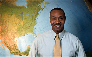
Marshall Shepherd, of the University of Georgia, uses NASA satellites such as the Tropical Rainfall Measuring Mission (TRMM) to study weather and climate. (Photograph courtesy Marshall Shepherd.) | ||
 | |||
It was the local weather-making processes that Shepherd wanted to learn about in 2001 when he started to look at coastal rainfall. NASA, in collaboration with the Japanese space agency, had launched a new satellite late in 1997 that was sending back the best estimates of rainfall in the tropics to date. By early 2001, the satellite had accumulated a three-year record. The record was long enough to begin to reveal year-to-year rainfall patterns. Shepherd was eager to see if the satellite had captured rainfall produced by local-scale events. As he surveyed the satellite data, he was looking for things like rainfall patterns created when a sea breeze interacts with coastal topography, but the pattern he saw emerging from the data of the southern United States surprised him. |
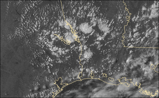
Summer afternoon thunderstorms are a common occurrence near the Gulf Coast. Humid air rising off the hot ground cools as it ascends. The water vapor in the air condenses, and clouds form. These storms sprang up along the border between Texas and Louisiana on September 6, 2006. (Image and animations by Robert Simmon, based on NOAA GOES super rapid-scan data.) | ||
 | |||
“I started noticing that around some of the cities, there seemed to be these anomalies in rainfall downwind,” Shepherd recalls. These downwind areas got more rain during the summer than other areas. Having spent his childhood in Atlanta, the idea that his city could be directly affecting the weather intrigued Shepherd. Had anyone else noticed this spike in rainfall? He combed through past studies and discovered that for more than a century, scientists had suspected that cities impact or maybe even create rain. Cities, Shepherd learned, are among the local factors that influence summer weather. “You need three basic ingredients for clouds and rainfall to develop,” Shepherd explains. “You need for air to be unstable.” Air is unstable when it is warmer than the air that surrounds it. Once the air is lifted, it will continue to rise. That instability usually happens when warm air nearest the Earth is pushed up into the cooler air above it. That leads to the second ingredient: a source of lift. “You need something that will get the air rising, whether that be a cold front, or a mountain, or a sea breeze, or a city.” When surrounded by cooler air, the warm air rises naturally like a hot air balloon. “Three, you need moisture.” If there is enough moisture in the rising, cooling air, the water vapor will condense into clouds and rain. But where does the city enter the process? |
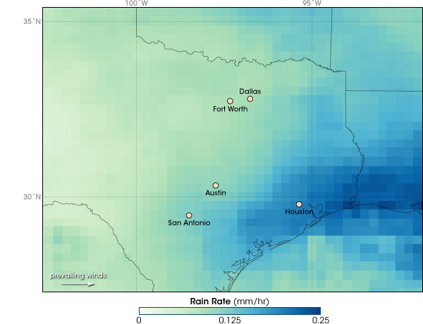
Measurements from TRMM revealed elevated rain rates downwind of urban areas in Texas. Marshall Shepherd noticed the pattern in summer rainfall while exploring the interactions between sea breezes and the urban landscape of Houston. The heaviest rain (blue) occurred downwind of Houston. This image is based on TRMM and rain-gauge measurements during July, August, and September from 1998 through 2006. (Map by Robert Simmon and Jesse Allen, based on Global Precipitation Analysis data.) | ||
alert message
