
 |
|||
Antarctic morning of December 2004 found Brian Stone peering at his computer screen. Miles away, across McMurdo Sound, two icebreakers were carving a path through the sea ice to the American base where Stone was waiting their arrival. Behind the icebreakers followed a fuel tanker and a cargo ship carrying critical supplies for McMurdo Station, the U.S. Antarctic research hub. Between the approaching ships and McMurdo, four massive icebergs lurked dangerously close to the shipping channel. As Research Support Manager for the National Science Foundation’s Office of Polar Programs, Stone was charged with the nuts and bolts of running a large research program on a vast, frozen continent. Among his responsibilities, Stone had to figure out how to get supplies to 700 researchers and more than 1,000 support personnel at three Antarctic research stations and numerous remote field camps. Getting the re-supply ships to McMurdo was just the first stage of the effort. From there, Stone would have to arrange for the supplies to be ferried by airplane to the other U.S. stations and field camps. |
(Image in title graphic courtesy National Science Foundation) |
||
 |
|||
The icebergs creating traffic problems in the Ross Sea that December were the most recent foe to be added to his list of everyday obstacles, including bitter cold, sudden fog, fierce winds, and blinding snow. Furthermore, Stone has to deal with all these problems without the extensive network of ground-based, weather-observation stations that forecasters and planners in less remote locations can take for granted. In a place where on-the-ground data are scarce, Stone and others operating research projects on our planet’s least-hospitable continent have been getting the upper hand on the extreme environment through satellite observations, including photo-like images, from NASA’s Moderate Resolution Imaging Spectroradiometer (MODIS) on the agency’s Terra and Aqua satellites. Later in the season, MODIS might be able to provide valuable information about clouds, wind, and water vapor to the weather forecasters who helped Stone plan flights. But at that moment, it was the ships that most worried Stone. As Stone checked his computer for the twice-daily delivery of MODIS images of the Ross Sea, what he wanted to know was exactly where the icebergs were moving. |
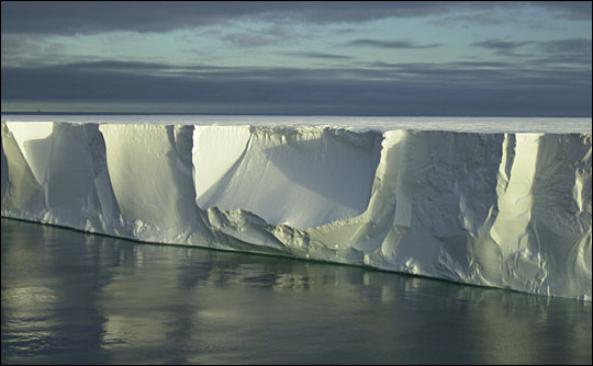
The massive B-15 iceberg that calved off the Ross Ice Shelf in 2000 eventually broke into several bergs that created navigation problems for ships supplying McMurdo Research Station in Antarctica in 2004. Josh Landis took this picture of the edge of the Rhode-Island-sized B-15A iceberg in 2001. (Photo courtesy Josh Landis, National Science Foundation, AWS/AMRC Photo Gallery) |
||