The Earth Observatory has published its last Image of the Day on this website. Please join us on our new home at science.nasa.gov/earth/earth-observatory.
 |
by Michon Scott February 5, 2002 |
||
|
On May 14, 1993, a young, physically fit man living in the American Southwest suddenly collapsed. He was rushed to a New Mexico hospital but died of acute respiratory failure within hours. The man had been on his way to a funeral — his fiancée died a similar death just days earlier. By May 17, medical center officials identified three similar deaths in the Four Corners region where the borders of Colorado, New Mexico, Arizona, and Utah meet. All of the victims had been young and otherwise healthy.
|
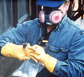
How can you minimize your risk of contracting hantavirus? Following these precautions may help:
The ESIP Federation is comprised of Earth Science Information Partners: government agencies, national laboratories, universities, nonprofit organizations, and commercial businesses. Type 1 ESIPs distribute satellite and ground-based data sets, and standardized products derived from those data sets. Type 2 ESIPs provide data and information products, technology, and/or services to the Earth science community. Type 3 ESIPs are primarily commercial companies that develop Earth science tools. The hantavirus risk map project used satellite data archived at the EROS Data Center. The EROS Data Center is a Type 1 ESIP, as are all of NASA's Distributed Active Archive Centers. The IBM Watson Research Center is a Type 2 ESIP. For more information, visit the Federation of Earth Science Information Partners. (A new browser window will open.) Visit the following for more information:
|
||
|
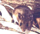
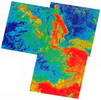
On May 18, the New Mexico Department of Health contacted the Centers for Disease Control and Prevention (CDC) for assistance, but laboratory tests failed to find a known disease among the victims. The CDC Special Pathogens Branch began a joint investigation with the state health departments of New Mexico, Colorado, and Utah, and with the Indian Health Service, the Navajo Nation, and the University of New Mexico. Three weeks later, the CDC identified the responsible pathogen: hantavirus. Hantaviruses are zoonoses, diseases that can be transmitted from animals to humans. Strains found primarily in Asia and Europe affect the kidneys and may cause severe circulatory problems, but less than 10 percent of the people infected die. The strain in the Four Corners outbreak, however, was different. Later named the Sin Nombre virus, it caused a much deadlier illness: hantavirus pulmonary syndrome (HPS). Affecting the heart and lungs, HPS has a mortality rate of 50 percent. Between 1993 and 1995, it claimed the lives of more than 45 people in the southwestern United States. Identifying the pathogen was only the first step in addressing the Four Corners outbreak. Next, researchers had to figure out how the disease spread. All previous cases of hantavirus were spread by rodents, so researchers began trapping and examining as many rodent species as possible in the Four Corners area. On June 14, 1993, the CDC identified the deer mouse, found throughout North America, as the primary carrier. Other rodents have also been found to carry viruses that cause hantavirus pulmonary syndrome: the cotton rat, ranging from the southeastern United States to South America; the rice rat, ranging from the southeastern United States to Central America; and the white-footed mouse, found throughout much of the United States and Mexico. Mice infected with hantavirus can transmit the disease to humans through bites that break the skin, but this is fairly rare. The virus usually spreads through "aerosolization" — a process through which infected mice shed the virus through their saliva, droppings, and urine, and humans inadvertently inhale the particles if they are stirred up. Although roughly 30 percent of the deer mice tested in the Four Corners region investigation were carrying the Sin Nombre virus, they weren't sick or dying. A virus does itself no favors by killing its host. "Smart" viruses coexist peacefully with their hosts, thereby prolonging their own lives, and the Sin Nombre virus may have coevolved with its rodent hosts for more than 20 million years. If humans were suddenly contracting the virus, their contact with the carrier rodents must have increased. Why? "That's what the field of epidemiology is all about," said Gregory Glass, associate professor at the Johns Hopkins Bloomberg School of Public Health. "We try to understand the factors that alter the risk people have for disease." Glass has used satellite data to map animal populations since the 1970s. He realized that if he could map the distribution of animals, he could also map the diseases they carry. To examine the Four Corners hantavirus outbreak, Glass used Landsat satellite images, archived at the EROS Data Center DAAC. He also collaborated with researchers at the IBM Watson Research Center Public Health Earth Science Information Partner. Understanding the Four Corners outbreak wasn't a simple matter of knowing where to look; scientists also had to know when to look. "Bob Parmenter, an ecologist at the University of New Mexico pointed out that mouse populations take some time to get big enough to cause disease in humans," Glass said. "So the time to be looking at the environment wasn't when people got sick, but probably before that."
Glass and fellow investigators started reviewing satellite images from 1992, the year before the outbreak. Early on, researchers hypothesized that the 1991-92 El Niño contributed significantly to the hantavirus outbreak by increasing precipitation. More precipitation meant more vegetation; more vegetation meant more mice. Yet, this hypothesis was based on data from just two study areas: the University of New Mexico's Sevilleta Long-Term Ecological Research Station, and Moab, Utah. Glass set out to test the hypothesis with a case-control study. "If you know where people were when they got the disease, you can use satellite data to monitor the environmental conditions where the outbreak happened," said Glass. "But there's a problem. You could, for example, conclude that the area where people got sick has lots of trees. Does that mean being around trees helps the disease spread, or does it just mean that people like to have trees around their homes?" He explained that a case-control study is one in which the environment and habits of the people who become ill (cases) are compared to those who did not contract the disease (controls). Glass and fellow researchers estimated precipitation at 28 case sites and 170 control sites during the springs of 1992 and 1993. They then compared those data to the previous six years' precipitation using rainfall records from 196 weather stations. They also examined Landsat Thematic Mapper satellite imagery collected the year before the outbreak to estimate the hantavirus pulmonary syndrome risk. Glass and his collaborators published the results of their study in the May-June 2000 issue of Emerging Infectious Diseases. What Glass found is that, while there is a relationship between precipitation and hantavirus, it's not as simple as previously thought. "One of the complicating factors relates to remote sensing. In areas that are semiarid, like the U.S. Southwest, the satellite readings don't correspond well with the actual amount of vegetation. The images show both vegetation and bare soil, and depending on the soil type, you can get false readings," Glass said. "Another complicating factor is the vegetation. I visited the Four Corners region during the next El Niño in 1998 and 1999 and realized that disease risk doesn't depend on the vegetation, per se. Broad categories of vegetation exist for high- and low-risk areas, but it's not a simple matter of saying piñon juniper forest is high risk, or salt bush lowlands is low risk." A crucial step in solving the puzzle, Glass said, is collecting ground truth data. He began overlaying risk maps from 1992 through 1998 to determine where the high-risk areas persisted, and he visited those sites with CDC researchers to learn more about them. "Mice might be fussier than we thought about where they live. The vegetation might look promising, but maybe the soil's too hard, so the mice can't burrow. Maybe there's not enough moisture in the soil. These are all things we have to figure out, and public health officials need remote sensing scientists to understand the nuances of the imagery." Another key to understanding hantavirus risk is acquiring more data. "We don't have enough statistical power to say much about precipitation patterns yet," Glass said. "An additional problem is that the data could be contaminated with past outbreaks of the disease. I'm positive there were earlier cases that just weren't recognized." The CDC agrees. Earlier cases of the Sin Nombre virus have been found in stored tissue samples taken from people who died of unknown lung diseases before the 1993 outbreak. Now, the earliest known case of the Sin Nombre virus has been confirmed in a 38-year-old Utah resident who died in 1959.
Do public health officials pay too much attention to illnesses like hantavirus pulmonary syndrome? "We don't have that many infectious diseases in the United States, so even 30 or 40 people dying from something is pretty frightening," Glass said. "You could compare the Four Corners outbreak to the recent anthrax outbreak. Nobody knew where it was coming from or how many people would be affected. With hantavirus, we didn't even know what it was or how it spread. So the problem isn't that you've got huge numbers of deaths, it's that you have a lot of people who don't know whether or not they've been exposed." Beyond protecting Americans, monitoring conditions in the United States can alleviate suffering elsewhere. "Diseases like malaria, schistosomiasis, and dengue fever affect hundreds of thousands, even millions of people. In many cases, animals provide a reservoir for germs, or spread them among humans, and those animals are influenced by the environment. Using satellite data the way we have for hantavirus gives us a good evaluation of the data's use. Does having an image every 16 days at 30-meter resolution tell us enough to make some predictions? If it does, we can start using the data; if it doesn't, we have better ideas for how to design the next sensor." One conclusion Glass reached from his research on zoonotic diseases is that outbreaks are more easily tied to environmental conditions when the carriers are arthropods. "The dynamics of arthropod populations, such as mosquitoes, are tightly linked to temperature and precipitation patterns. Vertebrates are generally bigger, they can move around more, and they can control their own body temperature. So while vertebrates certainly respond to the environment, it isn't clear just how they respond. That makes predicting hantavirus a little tougher." Predicting hantavirus outbreaks accurately is what Glass eventually hopes to do. "You could just be extra cautious and predict a lot of outbreaks, but you can cause almost as much concern by over-predicting as by under-predicting. Businesses that depend on tourists, hikers, backpackers, and campers really feel the economic crunch when an outbreak is predicted. "Being prepared for an outbreak helps mitigate the huge economic and emotional losses," Glass concluded. "Epidemiology has been a good detective tool, but it hasn't turned into a predictive science. Remote sensing and ground truthing can improve predictions. Once we understand the link between environment and disease, we ought to be able to forecast disease at least as well as we forecast the weather." Glass, Gregory E., James E. Cheek, Jonathan A. Patz, Timothy M. Shields, Timothy J. Doyle, Douglas A. Thoroughman, Darcy K. Hunt, Russell E. Enscore, Kenneth L. Gage, Charles Irland, C.J. Peters, and Ralph Bryan. 2000. Using Remotely Sensed Data to Identify Areas at Risk for Hantavirus Pulmonary Syndrome. Emerging Infectious Diseases. 6(3). All About Hantavirus from Centers for Disease Control and Prevention. Accessed August 15, 2001. Ecological Research Benefits: The Hantavirus Case Study (PDF file). Accessed January 9, 2002. Nichol, Stuart T., Jiro Arikawa, and Yoshihiro Kawaoka. 2000. Emerging Viral Diseases. PNAS. 97(23). |
|||