Temporary Drought or Permanent Desert? | |||
Desertification. The word invokes images of sand dunes blowing over abandoned farms as some irresistible, dark force steadily transforms fertile fields into inhospitable wasteland. The United Nations’ official definition says desertification is land degradation in typically dry areas resulting from various factors, including climatic variations and human activities. But for Prince and many other scientists studying desertification, this definition is too broad. “The definition encompasses things like drought, overgrazing, and inadvisable cropping,” says Prince. All of these conditions do suppress the ability of the land to support plant growth. “But if it starts to rain and vegetation returns, what do you call it?” Is the land still desertified? |
|||
 | |||
Scientists are beginning to say that desertification is a reduction in the productivity of the land that is not reversible. In other words, land is desertified when it can no longer support the same plant growth it had in the past, and the change is permanent on a human time scale. Many things can cause desertification. Drought, overgrazing, fire, and deforestation can thin out vegetation, leaving exposed soil. If the nutrient-rich top soil blows or washes away, plants may not be able to return. Overfarming or drought can change the soil so that rain no longer penetrates, and the plants lose the water they need to grow. If the changing force is lifted—drought ends or cattle are removed, for example—but the land cannot recover, it is desertified. The loss of productive land for a season or even a few years is one thing, but to lose it effectively for ever is clearly far more serious. “If we can agree on this definition, we can quantify [or measure] desertification,” says Sharon Nicholson, a professor of climatology at Florida State University. Like Prince, Nicholson has used the vegetation index to study desertification in the Sahel. But even if scientists can’t agree on the definition, the index can provide a consistent measure of symptoms in the same way that a doctor treating a patient with an unknown illness will track the symptoms such as fever, says Nicholson. The other thing that Prince and others needed to map out desertification in the Sahel was time. If land is not considered desertified unless the change is permanent, you need to track change over a long period—ten to twenty years at least—to see if vegetation is permanently altered. In 2006, Goddard’s Global Inventory Modeling and Mapping Studies (GIMMS) group, led by Tucker, released a twenty-four-year-long data set, the longest satellite-based vegetation record available. “The data set provides an essential 24-year record of vegetation dynamics that enables us to detect areas where degradation is taking place and areas of desertification,” says Prince. |
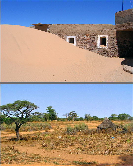
Despite its evocative name, desertification isn’t the march of sand dunes through inhabited areas. Rather, it is the permanent degradation of previously fertile land. Human causes of desertification include overgrazing, the buildup of salt in irrigated soils, and topsoil erosion. Permanent changes in climate, particularly rainfall, are responsible for natural desertification. Extended droughts may mimic desertification, but vegetation may recover when seasonal rains return. Scientists compare long-term satellite measurements of vegetation with rainfall data to help determine where desertification is occurring. [Photographs copyright Nick Brooks (upper) and Ewan Robinson (lower).] | ||
 | |||
Flip through the record from 1981 to 2005, and you see the seasons sweep north and south across Africa as plant growth rises and falls in synch with each revolution of the Earth around the Sun. Most importantly for understanding desertification, lay the years side-by-side with rainfall data, and you see where plant growth is changing over the long term—where productive land is becoming desert, and where it is not. Under normal conditions in the Sahel, plant growth rises and falls in synch with rainfall. If the land is desertified, growth will no longer follow the rains. The vegetation index over desertified land would remain low, even after rain. By isolating places where rainfall and vegetation no longer match, scientists like Prince can identify possible desertification. |
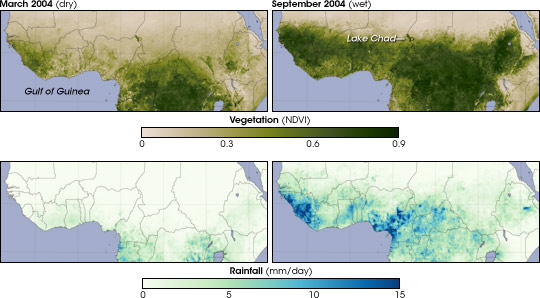
Vegetation in the Sahel follows seasonal rainfall. In March, during the dry season, rainfall and lush vegetation don’t extend north of the Gulf of Guinea. September brings rain and vegetation into the Sahel as far north as the northern edge of Lake Chad. Photographs from Senegal show the difference in vegetation between the dry (left) and wet (right) seasons.
(Maps and animation by Robert Simmon and Jesse Allen, based on GIMMS and TRMM data. Photographs courtesy USGS and USAID.) | ||
 | |||
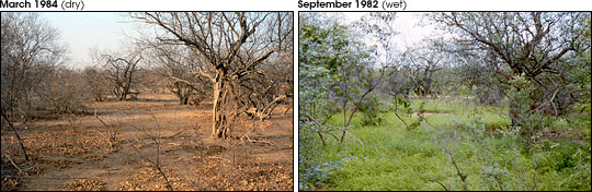
Rainfall tapered off in the Sahel in the early 1970s, and by 1972, the region was in the grip of a drought that would kill millions. Dry years followed until 1984, when almost no rain fell at all. The vegetation index mirrors these patterns of rainfall in the mid-1980s, and it also mirrors a partial recovery in 1994. By 2000, rain had returned to just below average and stayed at that relatively high level through 2006. The vegetation index shows green pushing back into the Sahel, responding to the rainfall patterns. “The Sahara is not advancing, but fluctuating like waves on the ocean,” says researcher Stefanie Herrmann from the Office of Arid Land Studies at the University of Arizona, Tucson. “There is no extensive desertification,” Prince agrees. “The popular concept of the desert marching south is wrong.” Instead, the large-scale changes in vegetation in the Sahel are mainly driven by the often-extreme rainfall variations. |
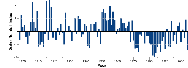
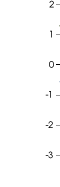
More than a century of rainfall data in the Sahel show an unusually wet period from 1950 until 1970 (positive index values), followed by extremely dry years from 1970 to 1990 (negative index values). From 1990 until 2004 rainfall returned to levels slightly below the 1898–1993 average, but year-to-year variability was high. (Graph adapted from Mitchell, 2005.) | ||
 |
The index does suggest signs of degradation in some parts of all the Sahelian countries. But while the index shows that the symptoms of desertification are there, figuring out the cause is another step. For example, the land could be degraded by overuse, but it could also be rocky with thin soils. It could be fields that have been tilled but not planted. While plants are not growing on the land, the land may not necessarily be desertified. Field work and higher-resolution (more detailed) satellite data are needed to confirm that desertification is driving the changes that scientists see in the satellite data. The vegetation index, “narrows the places to look for desertification,” says Prince, and that is a vast improvement over “pin pricks in a map.” |
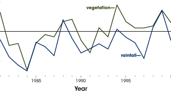
Rainfall records compared to satellite vegetation measurements since 1981 show reduced rainfall and vegetation cover during the severe droughts in the Sahel during the 1980s (blue line). In the 1990s and 2000s rainfall levels recovered somewhat, and vegetation returned (green line). Researchers concluded that any permanent desertification was limited to localized areas. (Graph adapted from Anyamba and Tucker, 2005.) | |
 | |||
|
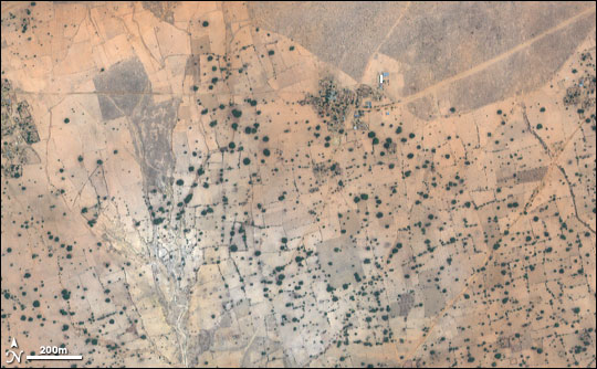
Although desertification is not occurring across the entire Sahel, it is likely occurring in specific areas. Medium and high-resolution satellite imagery can spot localized land degradation. This Ikonos image shows individual trees (dark circles), farm plots (polygon outlines), and a small village (dark patch at top center) in Mali on June 9, 2000. (Image by Robert Simmon, based on data copyright GeoEye and distributed via the USGS EarthExplorer.) | ||
alert message
