Aerosols, Floods, and Mudslides |
|||
Vast quantities of volcanic gases [mostly sulfur dioxide (SO2)] were blown into the atmosphere during the eruption. The globally
distributed aerosols were responsible for several phenomena, from spectacular sunsets to global cooling. |
The immediate consequences of the eruption—ashfall, mudflows, crop devastation, and destruction of villages and roads—affected tens of thousands of people. However the worst impact on the people of the region surrounding Pinatubo resulted from the lahars (volcanic mudflows). When the top of the mountain was blasted off, ash rained down on the upper slopes of Mt. Pinatubo, accumulating as loosely consolidated gravels and muds up to a few hundred meters thick. So much material was heaped on the mountain that all the natural river drainages were clogged. The main eruption occurred during a typhoon, and heavy rainfall flushed the volcanic muds and gravels downslope as lahars. Soon, all the downstream reaches of streams flowing down the mountain were also clogged—new drainage networks had to be reestablished. Periodically, loosely dammed drainages broke through catastrophically and swept downslope as more destructive mudflows. Described as floods with the consistency of wet cement, the lahars jumped river banks, and swept away or buried everything (towns, roads, bridges) in their paths (Rodolfo, 1995). |
These two photos show the Earth’s limb (the Earth’s horizon from orbit) at sunset before and after the Mt. Pinatubo eruption. The first view (STS41D-32-14) shows a relatively clear atmosphere, taken August 30,1984. Astronauts were looking at the profiles of high thunderstorms topping out at the tropopause at sunset; different atmospheric layers absorbed the last rays of light from the sun as the spacecraft moved eastward. The same type of photograph (STS043-22-23) was taken August 8, 1991, less than two months after the Pinatubo eruption. Two dark layers of aerosols make distinct boundaries in the atmosphere. The estimated altitude of aerosol layers in this view is 20 to 25 km, consistent with measurements made by other space-based instruments (SAGE II and AVHRR; Global Volcanism Program, 1991; Self et al., 1996). NASA images STS41D-32-14 and STS043-22-23. |
||
|
|||
In subsequent months and years, heavy rains (frequent during the monsoon months of June through November) mobilized more lahars. Villages in river floodplains on the lower slopes of the mountain were repeatedly threatened. In the first five years after the eruption, at least 400 km2 of land was covered by mudflows. More than 53,000 people were permanently displaced, including 20,000 indigenous Ayta people (Bautista, 1996; Pinatubo Observatory Team, 1991). These people remain removed from their cultural and spiritual home. Further, the extensive loss of agricultural land and irrigation sources, the destruction of roads and bridges, repeated floods and disease have affected more than 1,000,000 Filipino people (Bautista, 1996). |
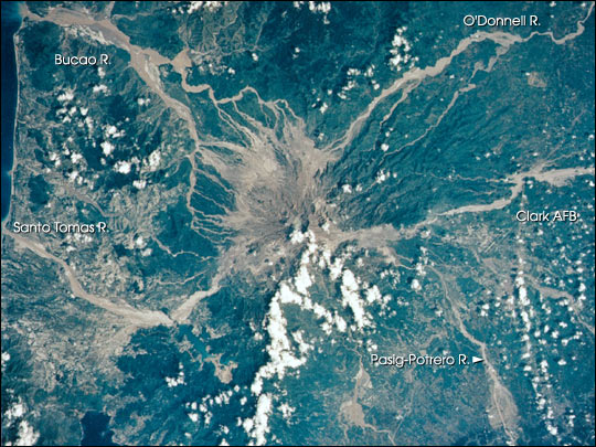
Astronauts observed Pinatubo just a few days after heavy monsoon rainfalls triggered lahars, or volcanic debris flows down the western slope of the mountain. This is the first detailed view of Pinatubo after the eruption. Fresh lahars on the Bucao River (top left) created extensive floods and swept away whole villages. NASA image STS046-75-79A. | ||
|
|||
Municipalities have attempted to mitigate future lahar damage by constructing earthen levees along the edges of rivers, with hopes of channeling mudflows. Unfortunately, several levees have failed, such as along the Santo Tomas River on the southwest side of the mountain, and repeatedly along the Pasig-Potrero River on the southeast side of Pinatubo (Rodolfo, 1995; Newhall and Punongbayan, 1996; Umbal, 1997). Levees concentrated the lahar flows, occasionally resulting in catastrophic breakthoughs and floods. Although less frequent today, Pinatubo lahars still occur after exceptionally heavy rains. |
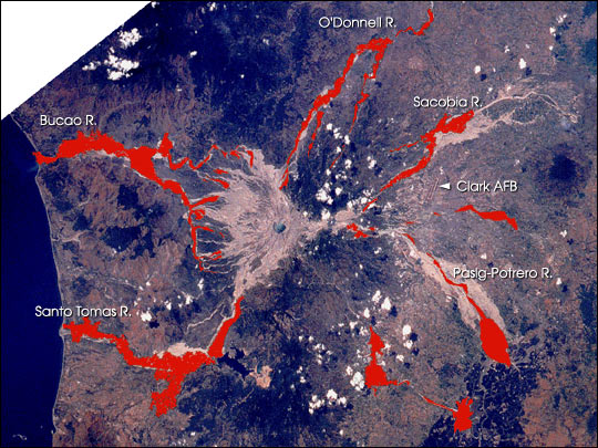
The areas covered by lahars in early August 1992 (shown in red, and mapped from STS046-75-79A) are overlaid on a March 14,1995 image of Pinatubo (STS067-721a-31). By 1995, more than 400 km2 of land was buried by lahars. | ||
|
|||
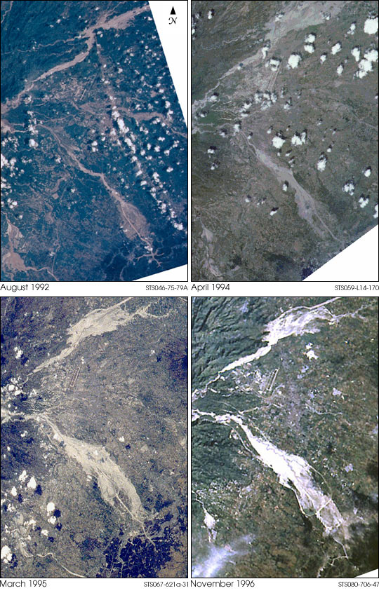
Astronauts continue to photograph the changing landscape around Mt. Pinatubo. Several types of changes are being monitored: The lahars (mudflows) are easily identified on photographs from space: the light, even-colored river drainages radiate outward from the center of the mountain. An excellent time series of images taken before and after monsoon seasons from 1992 through 1996 captures downstream changes on the major river systems draining Mt. Pinatubo. In a sense, Mt. Pinatubo serves as a laboratory for studying how drainage networks become established over a very short time. Coastal changes continue. As large quantities of materials moved downstream and to the coast of the South China Sea, shorelines around river mouths changed. Delta formation and longshore drift of sediment around Santo Tomas and Bucao River systems create rapidly changing shorelines. (Siringan and Ringor, 1995) Civil engineering efforts continue—in later years, efforts to construct more permanent levees and dams to retain the muds can be seen. The region around the Pasig Potrero has been walled off by levees and sediment retention structures. Astronaut photographs document the ponding of mudflows behind these structures. Forest and agriculture regrowth is underway. Ten years after the eruption, the mountain slopes are becoming green with vegetation. It will be decades before the tropical jungle is fully reestablished on the upper slopes of the mountain, but the vantage point from space allows for excellent documentation of the changes in vegetation. As lahar activity diminishes, the fertile mudflow deposits are being cultivated for crops such as rice. Today, astronauts and cosmonauts aboard the International Space Station Alpha and Space Shuttles are on the constant lookout for volcanic eruptions in other parts of the world. The crews use their long-term observations of Mt. Pinatubo as an example of the types and magnitudes of changes that can be monitored over other volcanic regions. Reference: Global Volcanism Program Volcanic Activity Reports, Bulletin of the Global Volcanism Network, 1991 Newhall, C. G. and Punongbayan, R.S. (eds.), Fire and Mud: Eruptions and lahars of Mount Pinatubo, Philippines Philippine Institute of Volcanology and Seismology, Quezon City, and University of Washington Press, Seattle and London,1996. Pinatubo Volcano Observatory Team, Lessons from a major eruption: Mt. Pinatubo, Philippines, EOS, Trans Am Geophys Union, 72: 545,552-553,555; 1991 Rodolfo, K.S., Pinatubo and the politics of lahar, University of the Philippines Press, Manila, Philippines, 334p., 1995. Scott, W.E., Hoblitt, R.P., Torres, R.C, Self, S., Martinez, Ma. Nillos, T., Jr., Pyroclastic flows of the June 15, 1991 climactic eruption of Mount Pinatubo, in Newhall, C. G. and Punongbayan, R.S. (eds.), Fire and Mud: Eruptions and lahars of Mount Pinatubo, Philippines Philippine Institute of Volcanology and Seismology, Quezon City, and University of Washington Press, Seattle and London,1996. Self, S., Zhao,J-X, Holasek, R.E., Torres, R.C., and. King, A.J., The atmospheric impact of the 1991 Mount Pinatubo eruption, in Newhall, C. G. and Punongbayan, R.S. (eds.), Fire and Mud: Eruptions and lahars of Mount Pinatubo, Philippines Philippine Institute of Volcanology and Seismology, Quezon City, and University of Washington Press, Seattle and London,1996. Siringan, F.P. and Ringor, C.L., Long-term and short-term shoreline changes along the Zambales coast: Controls of shoreline change and the impact of the 1991 Mt. Pinatubo eruption., Geocon-95 VIII Annual Geological Convention, Proceedings, Geological Society of the Philippines,1995 Umbal, J. V., Five years of lahars at Pinatubo volcano: declining but still potentially lethal hazards, Jour Geol. Soc. Philippines, LII:1-19, 1997. Cynthia A. Evans is a scientist (Lockheed-Martin Space Operations) in the Earth Sciences and Image Analysis Laboratory at the NASA Johnson Space Center. The images above are provided by the Earth Sciences and Image Analysis Laboratory at Johnson Space Center. Additional images taken by astronauts and cosmonauts can be viewed at the NASA-JSC Gateway to Astronaut Photography of Earth |
The Pasig-Potrero River drains eastern slopes of Mt. Pinatubo, just south of Clark Air Force Base. Some of the most destructive floods have swept down this river drainage due, in part, to channeling and breakout of the mudflows through levees built to confine the lahars (Rodolfo, 1995; Umbal 1997). The time series shown here centers on the river and the progressively flooded regions surrounding the Pasig-Potrero from 1992 to 1996. After the 1994 floods, new levees to contain the mudflows were constructed, and a reinforced dam was built along the southern slopes to create a sediment retention area (Umbal, 1997). August 1992 STS046-75-79A |
||