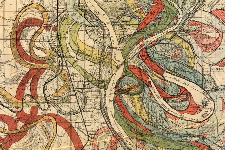
Historic flooding along the Mississippi River gives me an excuse to show another of my favorite maps, from Geological Investigation of the Alluvial Valley of the Lower Mississippi River.

Each color represents an old channel, dating back 1,000 years or so. Those that correspond to historical records are dated, while older channels are ordered according to the principle of superposition (newer sediments on top of older ones). Many of the surface layers are still visible in satellite imagery. High-resolution, geolocated maps from Cairo to the Gulf, along with major tributaries, geological maps, and cross sections, are distributed by the U.S. Army Corps of Engineers.


change the design of the cities and don’t try to change a river!
How do I get a url for the overlay you feature but lower on the river, at the confluence of Arkansas and Missisippi near quads for Big Island or Watson?
When will we learn, don’t screw with Mother Nature?
Excellent information, but an unfortunate choice of colors for the red/green color-blind.
Delta: On the US Army Corps of Engineers page I pointed to, there’s a series of links under “documents” along the left hand side of the page. You can download the full report, scans of the plates, and orthorectified plates. They’re very large zipped archives.
http://lmvmapping.erdc.usace.army.mil/RiverBasins/Fisk_44_report.zip
http://lmvmapping.erdc.usace.army.mil/RiverBasins/Oversized_Plates.zip
http://lmvmapping.erdc.usace.army.mil/RiverBasins/Fisk_Rectified.zip
Kit: You’re right, although I think the colors have faded a bit. The originals may have been better.
Levees are a disaster. Rivers need flood plains and no structures should ever be built in them.
I have always been intriqed when it comes to ‘ mother earth ‘ . Can’t get enough , and don’t know enough to ask the right questions !
I agree with Peter, it makes no economic sense to build on floodplains.
So I also agree with Peter and Harry, we also would save on money helping people with thear dameged homes
Anyone know if there are reprints of this map available for purchase?
Margaret: I don’t know of anyone selling prints, but you could download some of the TIFFs (links above) and print them via Zazzle, Cafe Press, or a similar service.
Please tell me how to get a map of the northern Mississippi alluvial valley . . . the area between Keokuk, Iowa,
and Memphis, TN. Are they available ?
It would be neat to track the locations of prehistoric sites along this meandering maze to see where people put their villages, monuments, and cemeteries.
The entire set of maps is available here: http://lmvmapping.erdc.usace.army.mil/index.htm
Margaret: The original sets of Harold Fisk’s maps are collector’s items. A geologist with whom I worked years ago had a set in his office. His father was Exploration VP of Humble, for whom Fisk was chief of geologic research. You can download TIFF images of the maps from the Corps of Engineers website.
There is a newer set of geologic maps of the Lower Mississippi Valley, by Saucier, R. T., 1994, Geomorphology and Quaternary Geologic History of the Lower Mississippi Valley: U. S. Army Engineer Waterways Experiment Station, Vicksburg, Mississippi.published by the U.S. Army Corps of Engineers. They are mapped at a scale of 1:100,000 and bound in folio form. There is also a text which accompanies the maps, which still might be available for purchase. Go to:
http://lmvmapping.erdc.usace.army.mil/