
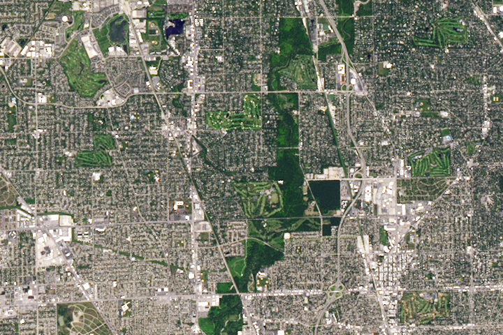
Update on August 23, 2024: This Landsat 8 image shows several golf courses north of Chicago. Congratulations to Jeff Pettett for being the first reader to identify the location and spot the golf courses. Read more about the area in “Golfing in Illinois.”
Every month on Earth Matters, we offer a puzzling satellite image. The August 2024 puzzler is shown above. Your challenge is to use the comments section to tell us where it is, what we are looking at, and why it is interesting.
How to answer. You can use a few words or several paragraphs. You might simply tell us the location, or you can dig deeper and offer details about what satellite and instrument produced the image, what spectral bands were used to create it, or what is compelling about some obscure feature. If you think something is interesting or noteworthy, tell us about it.
The prize. We cannot offer prize money or a trip on the International Space Station, but we can promise you credit and glory. Well, maybe just credit. Within a week after a puzzler image appears on this blog, we will post an annotated and captioned version as our Image of the Day. After we post the answer, we will acknowledge the first person to correctly identify the image at the bottom of this blog post. We also may recognize readers who offer the most interesting tidbits of information. Please include your preferred name or alias with your comment. If you work for or attend an institution that you would like to recognize, please mention that as well.
Recent winners. If you have won the puzzler in the past few months, or if you work in geospatial imaging, please hold your answer for at least a day to give less experienced readers a chance.
Releasing comments. Savvy readers have solved some puzzlers after a few minutes. To give more people a chance, we may wait 24 to 48 hours before posting comments. Good luck!
This shot is centered on Glenview, Illinois, and the neighboring community of Golf. The North Branch of the Chicago River flows through the Harms Woods forest preserve that runs from top to bottom in the picture. The Edens Expressway (I-94) is east of the river; the visible interchanges from bottom to top are for Dempster St., Old Orchard Rd., and Lake Ave./Skokie Blvd., respectively. The road running diagonally from bottom center to top left is Illinois 43, commonly known as Waukegan Rd. Running east-west across the top half of the shot is Lake Ave. (It was the S curve just west of the Lake & Waukegan intersection that first caught my eye.)
Having grown up in Glenview, I’ve no idea why this shot would be interesting to a wider audience. But here’s a wild guess: Is it perhaps because of the number (and quality!) of championship 18-hole golf courses concentrated here? Just below dead center in this picture is the Glen View Club, which hosted the U.S. Open in 1904; not far to the north of the Glen View Club is the North Shore Country Club, which hosted the U.S. Open in 1933. The Chick Evans Golf Course, located just south of the Glen View Club across Golf Rd. [go figure] is named for the U.S. Open Champion of 1916. Near top center in the shot is the Wilmette Golf Club, and the Indian Hill Club is at top right; both are in Wilmette, and as I understand it, Bill Murray did his caddying at Indian Hill. The Westmoreland Country Club (right center) and Evanston Golf Club (bottom right) are both in Skokie. Left of center in the shot is the Glenview Park Golf Club; north of that are the Glen Club and the 9-hole Glenview Prairie Club (both of which were built on the grounds of the former Glenview Naval Air Station, which was closed in the mid-1990s; many WWII-era fliers trained at NAS Glenview, among them one George Herbert Walker Bush).
Or am I way off?
Oh! In the submission I just sent, I made one embarrassing error of identification. The diagonal line running bottom center toward top left is *not* Illinois 43/Waukegan Rd.; it’s the Milwaukee District-North commuter railroad! Waukegan Rd. instead runs straight south to north, crossing the railroad near left center in the picture. In my haste to post, I neglected to note the distinction between the railroad line and the thoroughfare. Sorry about that.
I believe this is a view of Boston’s “Emerald Necklace” , the park system designed by F.L.Olmstead.
Suburban NW Chicago, Glenview, Morton Grove etc, Golf Road running east-west in the upper third, I 294 running north-south on the right side. The north branch of the Chicago River runs through the green corridor. Lake Michigan out of view to the east.
Around Morton Grove, IL.
Landsat9 True Color Image?
the satellite image is of boston, but it’s particularly notable because what you can see so much of is the “emerald necklace”, designed by frederick law olmsted and an important part of the boston area landscape.
Loads of golf courses.
Pittsburgh,PA – based on the number of bridges.
Many golf courses, possibly two cemeteries. A older well established suburban area with cheaper land when the golf courses were established. Well drained soil with sandy bunkers a feature. An older retired demographic supporting the viability of the golf course. This could be The Sandbelt in Melbourne Australia but it isn’t!
Paris
North suburban Chicago. The Eden’s expressway snakes northward with the Chicago River’s North Branch flowing southward just to the west of the highway. The radial lines are reaching out from the heart of the city proper. They are streets and railroads, several of which followed Native American trails from pre-Columbian times. In particular there are Milwaukee Avenue, Shermer Road, Lehigh Road, the Metra/Amtrak railroad tracks. Additionally, two major shopping malls—Golf-Mill and Old Orchard—appear in the photo. Both of them Ave seen better days. The Illinois Holocaust Museum is pretty close to the center of the image. One hundred years ago, most of the land in the picture was wet marshland, but in order to develop the area, a major effort was made to drain the excess water.
Morton Grove – a village in Cook County, Illinois, United States.
aerial view of Naval Air Station Glenview airport
NW Chicago Suburbs, Glenview, Morton Grove, Wilmette, and Northfield. Completely encircled by Interstates 90, 294, and 94.
I’m guessing Florida. I count at least half a dozen golf courses.
Hi!
It´s Niles, Illinois! It looks like a Landsat image in real color combination.
I don´t know the city, but I can identify a golf course and a large number of deforested areas in the form of strips.
I could found some information about the city. It´s called “Little Italy” and it has a reproduction of the leaning Tower of Pisa!!
The photo is the Netherlands. It is interesting because it shows the network of dams.
Not sure, but looks like an overflowing river.
The first thought that comes to mind is how this image shows a constrained floodplain with development and many golf courses on the fringe.
Vegas baby
We are presented a portion of Chicago bounded by Hwy 43 and Hwy 21 in the Glenview area. The photo showed (1) a number of golf courses and (2) a curious pair of roads radiating from an off-screen location. What metropolitan area would have these characteristics? The Chicago suburbs.
I can’t enlarge this photo and still retain the clarity (sounds a bit like life), but my eye is caught by what seem to be eight golf courses in a densely settled place. Is it Japan, I ask myself. Or maybe the US – yes, more likely. And a marvellous grid system of town planning.
I spent maybe 15 minutes looking at this image and thinking about it. it led me to find out a little bit about golf courses and grids, and then to stray somehow from the grid system on to the concept of ‘hostile architecture’: designing to thwart patterns of behaviour deemed undesirable — putting seat dividers on a bench seat so that no-one can stretch out and sleep on them, for example. An uglier side to humanity, I can’t help but feel.
Thanks for making me pause and look a bit more carefully.
Myrtle Beach, SC, I asked Google a Q: “place with most golf courses”.
O interessante na imagem foi a preservação das matas ciliares de um corpo hídrico que passa por uma cidade bastante urbanizada.
The villages in Central Florida
It looks like there are a few golf courses as well as neighborhoods that remind me of Tampa.
Filter the image into the dataset I imagine it to be a long thin strip of land next to the keys in fl,may be tampa.
The color green is interesting and not red so there is sunlight,at the deep end there are 2 square box,they could be golf course.The information on the map indicated that this is a vertical shape maybe 50-60 miniature,leading edge is the surrounding things around the green area,almost like a park.It make perfect image from landsat about the landscape,showing that this is not a steady state region.
Protection of the green area is started in here in a basic shape,there is not a sign of heavy rainfalls but if it is coastal the dangers is not far away.It could be 42 km away as estimate by satellite,finer resolution is required to get regional information about this picture,it is interesting if it is fl,home to the space launch and regular hurricance.
From solse2 reflection on the earth’s limb this area is north of the globe grid to a major city may be miami.
Morton Grove Illinois area, large number of 18-hole courses in a pretty small space. looks to be about 15 square miles or so.
This shows the northern suburbs of Chicago, with I-94 running north-south in the center-right portion of the image. The tipoff that it is Chicagoland is the long, straight parallel roads that look like they will intersect if you follow the image southward (toward downtown). scrolling East a short distance would take you over Lake Michigan.