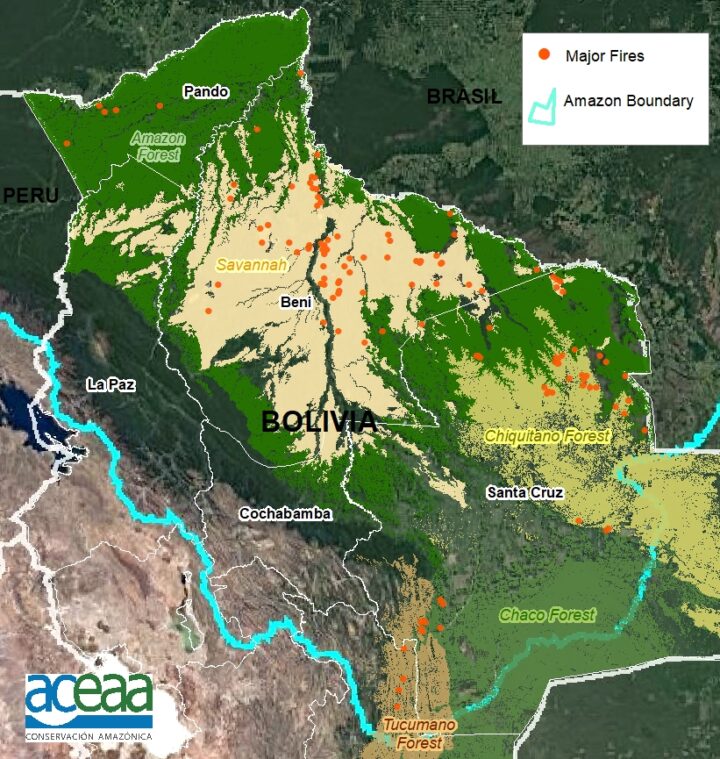
For the second year in a row, fierce fires have burned throughout Bolivia. They are the product of a prolonged drought, which has supercharged the fires that are lit seasonally by farmers and ranchers to maintain grazing land and to clear forest and woodlands for agricultural production.
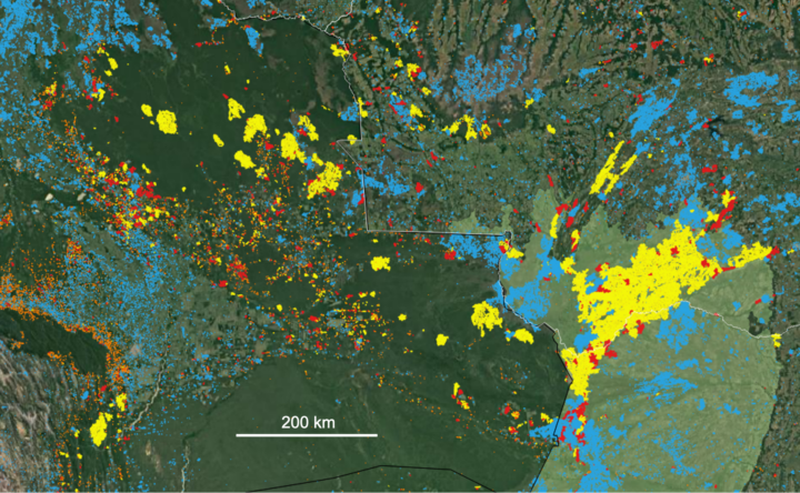
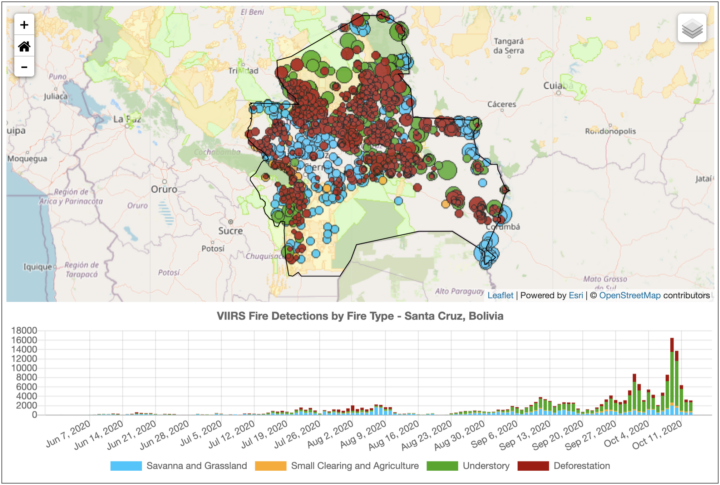
Sensors on NASA and NOAA satellites – including the Moderate Resolution Imaging Spectroradiometer (MODIS) and Visible Infrared Imaging Radiometer Suite (VIIRS) – map where fires are actively burning on Earth each day. For instance, the map from NASA’s Fire Information for Resource Management System (FIRMS) below shows all of the fire detections in Bolivia that VIIRS observed on October 16, 2020.
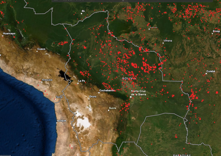
But not all the red dots on the map are of equal ecological significance. As these screenshots (below) from NASA’s Amazon fire dashboard make clear, there is a lot of variety in the types of fires that have burned in Bolivia in recent months, and they vary by region and ecosystem.
Many fires in the region are short-lived grassland and savanna fires; these burn vegetation that regrows quickly, and there is usually little ecological damage and minimal carbon emissions. Likewise, many others are small-scale land clearing and agricultural fires that do not cause substantial new damage to intact tropical forests.
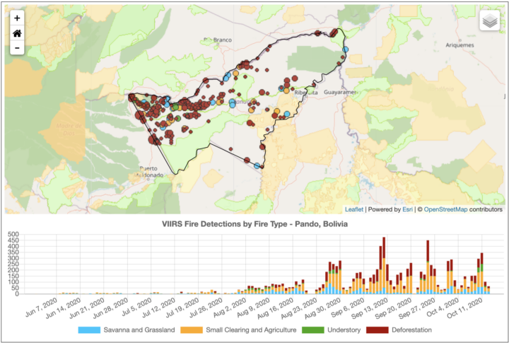
On the other hand, some of those red dots are long-lasting, intense deforestation fires that were lit specifically to burn trees as part of land-clearing processes. These fires turn patches of tropical forests into pasture or cropland, fragmenting the remaining forests and altering ecosystems for decades.
Others are low-intensity understory fires that typically begin in cleared areas as agricultural fires, but then escape into neighboring forests. Even a low-intensity fire may kill half of the trees, unleashing a cascade of ecological changes that can transform tropical forests into open-canopy woodlands over time.
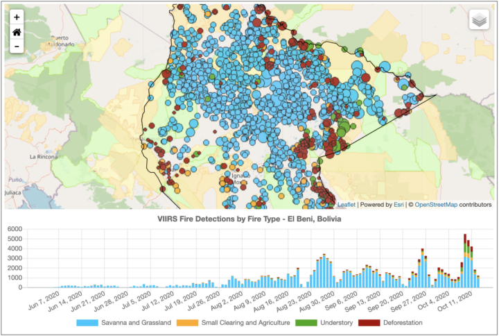
The charts above highlight the types and trends of fire type for three states (departments) in Bolivia. The northerly Pando department is still dominated by intact tropical rainforest. Satellites have detected large numbers of deforestation and agricultural fires burning there since August 2020, particularly along Highway 13. With more grasslands and fewer forests, El Beni has a higher proportion of the less-damaging fire types. The large Santa Cruz department, home to the Chiquitano dry forest and Pantanal grasslands, has comparatively large numbers of understory and grass fires.
“The goal of our new classification system is to provide real-time information on what types of fires are burning across the Amazon region every day. With thousands of individual fires burning at this point in the dry season, the question is how to prioritize regional efforts for fire suppression to best protect communities and ecosystems. Understory fires are particularly devastating in Amazon forests that are not adapted to fire,” said Douglas Morton, chief of the Biospheric Sciences Laboratory at NASA’s Goddard Space Flight Center. “However, it is worth pointing out that our real-time classification system for Amazon fires is not the only way of categorizing fires. We are working closely with state and national agencies across the Amazon to improve the classification, based on feedback from field crews.”
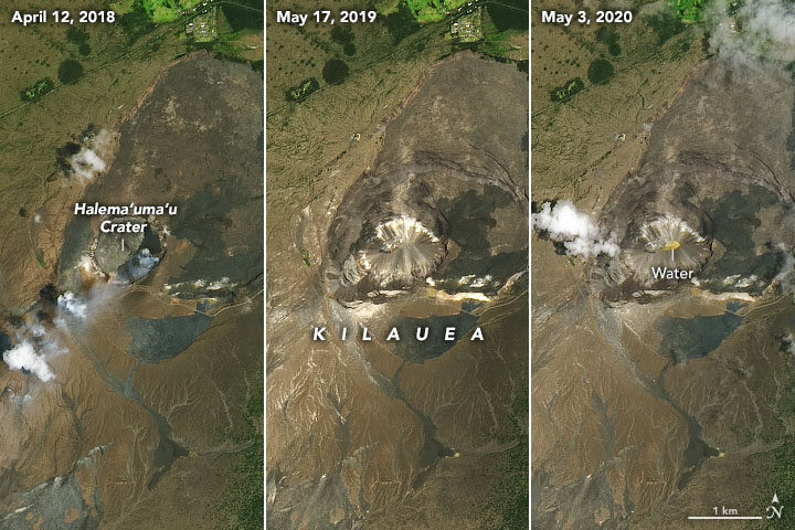
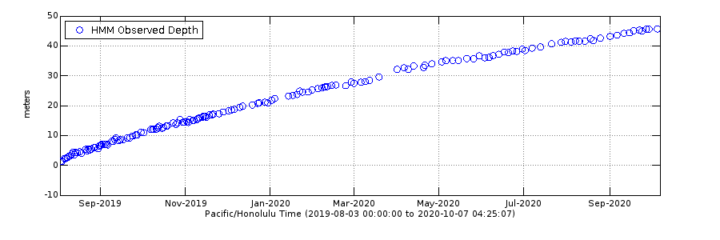
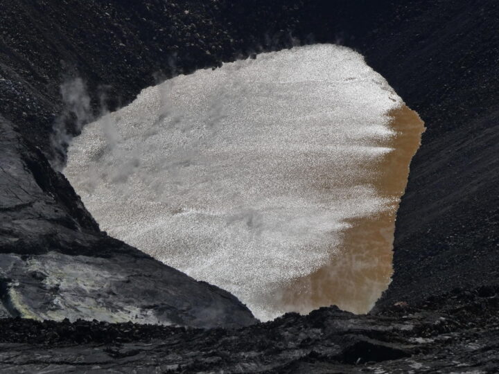
In May 2020, we published a story about a new lake growing in the summit caldera of Hawaii’s Kīlauea volcano. Six months later, the heated lake continues to rise. The water level now tops 40 meters (130 feet), according to U.S Geological Survey (USGS) measurements made with a laser rangefinder.
Though gentle “effusive” eruptions have been the norm at Kīlauea across the past two centuries, the geologic record shows plenty of evidence that the volcano has had periods when violent, explosive eruptions were common. The presence of water in magma is a key factor contributing to explosive eruptions, so USGS scientists have been carefully monitoring the volcano for signs that it may be entering a more explosive and dangerous phase.
As detailed in a September 2020 EOS article, that monitoring has included sending unoccupied aircraft systems (UAS)—drones—deep into the crater to get a closer look at the lake. Scientists have also been conducting regular helicopter flights over the lake and monitoring a suite of ground-based sensors (seismometers, GPS sites, thermal cameras, and others) that measure the motion of the ground, gaseous emissions, and the appearance and temperature of the lake.
Meanwhile, satellites provide the big-picture view. Landsat satellites periodically collect multi-spectral imagery of the lake; the images at the top of this page provide a natural-color perspective. Other satellites with Interferometric Aperture Radar (InSAR) complement the ground-based GPS sites by offering a crucial, large-scale view of land deformation.
“The chance to monitor an incipient volcanic lake is not unprecedented, but it is rare,” a group of USGS geologists wrote in EOS. “Kīlauea’s crater lake provides an opportunity to improve the scientific community’s understanding of how such lakes evolve and interact with magmatic systems below.”
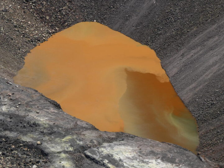
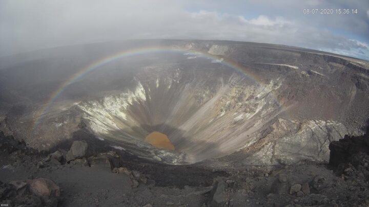
One byproduct of all the scientific monitoring is a steady stream of lake imagery that is visually striking as well as scientifically interesting. In July, for instance, morning sunglint transformed the muddy brown water to something that glittered and shimmered (see photo above). Influxes of new water often set up gradients of color that range from green to rusty orange (also above). And on a day when a light mist moved across the caldera, a webcam at the summit acquired a striking image of a rainbow framing the lake (below). You can find more images in Hawaii Volcano Observatory’s photo and video chronology.
alert message
