Every month on Earth Matters, we offer a puzzling satellite image. The November 2019 puzzler is above. Your challenge is to use the comments section to tell us what we are looking at, where it is, and why it is interesting.
November 2019 puzzler is above. Your challenge is to use the comments section to tell us what we are looking at, where it is, and why it is interesting.
How to answer. You can use a few words or several paragraphs. You might simply tell us the location. Or you can dig deeper and explain what satellite and instrument produced the image, what spectral bands were used to create it, or what is compelling about some obscure feature in the image. If you think something is interesting or noteworthy, tell us about it.
The prize. We can’t offer prize money or a trip to Mars, but we can promise you credit and glory. Well, maybe just credit. Roughly one week after a puzzler image appears on this blog, we will post an annotated and captioned version as our Image of the Day. After we post the answer, we will acknowledge the first person to correctly identify the image at the bottom of this blog post. We also may recognize readers who offer the most interesting tidbits of information about the geological, meteorological, or human processes that have shaped the landscape. Please include your preferred name or alias with your comment. If you work for or attend an institution that you would like to recognize, please mention that as well.
Recent winners. If you’ve won the puzzler in the past few months or if you work in geospatial imaging, please hold your answer for at least a day to give less experienced readers a chance.
Releasing Comments. Savvy readers have solved some puzzlers after a few minutes. To give more people a chance, we may wait 24 to 48 hours before posting comments.
Good luck!
See our “A Burial Site Fit for an Emperor“ Image of the Day for the answer.
Tags: remote sensing, satellite


Osaka! One of the places I want to visit to see the kofun or ancient cemetery! Always wondering if it is better to see from above, rather than ground level.
There is Osaka – Japan
inside satellite image I can observe one of the highlights place the “Mausoleum of Emperor Nintoku”
I recognized because I already visited the place.
I am Paraguayan nikkei from Paraguay. I am interested in because I am I trying to enter aeronautical engineering In the National University of Asunción.
And I also participated in the ESI 2019 Abu Dhabi. Thanks
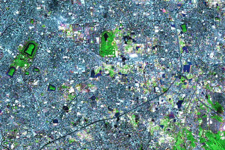
The funky keyhole-shaped islands surrounded by moats are Japanese kofun, which are ancient tombs, akin to Egyptian pyramids. Specifically, the one in the northwest corner of this image is Daisen Kofun, located in Sakai, Osaka.
False color image of Sakai, Japan featuring the keyhole-shaped Mozu tombs.
Mozu tumuli in Sakai, Osaka Prefecture, Japan.
The largest keyhole shaped tomb in the upper left is Daisen Kofun at 34.564°N 135.487°E, the largest of all kofun, supposedly the mausoleum of Emperor Nintoku of the, ah, Kofun period (3rd to 6th century AD) – since 2019 on UNESCO’s World Heritage list.
Not all kofun are keyhole-shaped, but those make this puzzler rather easy because there (probably?) aren’t other largish keyhole shaped artifacts on this earth.
Sakai, Osaka, Japan and the Mozu Kofun burial mounds
This Sakai, Osaka prefecture, Japan. It’s most notable features are the kofun, keyhole-shaped burial mounds.
Sakai Japan known for its burial mounds some set in the middle of ponds called the Mozu Kofun Tombs shaped like keyholes
This is a photograph of the Keyhole Tombs in Japan. Kofun are megalithic tombs or tumuli in Japan, constructed between the early 3rd century and the early 7th century AD. The term is the origin of the name of the Kofun period, which indicates the middle 3rd century to early–middle 6th century. Wikipedia
At very first I saw the image, I thought the key point of this satellite image is the KEYHOLE shaped-green coloured.
So I looked up online and found about the KOFUN.
.
Kofun are ‘ancient grave’ in japanese. Constructed between 3rd and 7th century.
The Mozu-Furuichi kofungun were inscribed to UNESCO world Heritage List in 2019.
.
From another NASA images, I learned that this image taken by operational Land Imager (OLI) on #Landsat 8.
Taken by combining shortwave-infrared, near-infrared and green portions of the electromagnetic spectrum, the vegetation looks bright green.
Sakai City, Osaka Prefecture. You can see several of the Mozu Tombs in this image. Looks like a Landsat 8 image, bands 7,6,4(RGB). Kudos to the Clark University Geography Department for getting me here ;]
Sakai, Japan.
Let this for researchers to get us more. Is it an aerial image in Bangladesh. Or where exactly?
I’m always defensive sorta-which makes me unpredictable offensively. anyhow, yes-definitely main island of Japan-whatever city of those tombs! I noticed this picture has some kinda of imaginery enhancements. made to look like taken at night. could’ve been daytime. don’t know for sure. picture could even be fake. whatever the case-the largest line on picture I presume to be a waterway. large enough for huge ships to cross main island sorta like the “Panama canal”. or . they cut it out for a main line to a sewer system. using straight ocean salt water and the earths natural movements of its tides. I hate being militaryish but its just my nature. (michael)