
Signs of an Impending EruptionBecause of the near-daily global coverage, MODIS data are ideal for quickly providing researchers with information about new eruptions. Other types of satellite data, such as Synthetic Aperture Radar (SAR), are better suited to looking at the geologic changes that often precede an eruption. Although these data don’t yet provide the quick turnaround time required for detecting new activity, they instead provide the spatial coverage necessary for scientists to see how the ground surface is deforming over a broad region. Surface changes were key to understanding a major volcanic eruption in 2002. Mount Nyiragongo, located in the Democratic Republic of the Congo, is one of Africa’s most active volcanoes. During an eruptive phase in 1994, a lava lake formed in the volcano’s summit crater. Lava lakes consist of large volumes of molten lava contained within a vent, crater, or broad depression. After its lava lake formed, Nyiragongo calmed down for about eight years. Then, on January 17, 2002, a major eruption occurred—with little warning. Lack of warning at Nyiragongo has grave implications: the city of Goma sits about 9 miles (15 kilometers) south of the volcano. “About 500,000 people live in Goma and its immediate vicinity,” said Michael Poland, geophysicist at Cascades Volcano Observatory in Vancouver, Washington. “Nyiragongo has a reputation for spawning pretty nasty lava flows. The potential hazard to human life there is significant.” Ground data are not easy to come by in the region of Nyiragongo. “It’s a dangerous place for field research,” said Poland. “There’s the Ebola virus and an ongoing civil war. Top that off with an erupting volcano, and you have a pretty volatile situation for a field researcher.” Add to those dangers the region’s lack of technology, and it’s no surprise that Nyiragongo has little monitoring history. “Collecting and recovering data in the Congo is made more difficult because there are problems with equipment being stolen,” Poland added. “So in addition to putting monitoring equipment in place, you have to hire three or four people to guard it. It gets to be quite costly.” Despite the lack of ground data, Poland learned of some anecdotal evidence of deformation from Congolese researchers. “The local townspeople typically wash their clothes in Lake Kivu, which is located adjacent to Goma. One day, they noticed that the rocks they normally used to dry their clothes on the shoreline were actually under water, so the lake level had come up—indicating subsidence,” said Poland. Measurements of the lake level before and after the eruption later confirmed this evidence. Poland recognized the 2002 Nyiragongo event as an opportunity to use SAR satellite imagery to analyze how the eruption deformed the ground on and around the volcano. Ground deformation refers to surface changes on a volcano, such as subsidence (sinking), tilting, or bulge formation, due to the movement of magma below the surface. Deformation changes at a volcano, such as those related to magnitude or location, may indicate that an eruption is about to occur. An example of visible deformation occurred in 1980 when a bulge appeared on the north flank of Mount St. Helens prior to its May 18 eruption. Scientists estimated that just before the eruption, the bulge was growing at a rate of 5 feet (1.5 meters) per day. |
|
||
 |
|||
|
To determine whether deformation preceded the Nyiragongo eruption, Poland requested SAR data from the Alaska Satellite Facility Distributed Active Archive Center (ASF DAAC). SAR interferometry, or InSAR, is one of the few methods available for remotely analyzing ground deformation that accompanies or precedes volcanic activity. The technique operates on the premise that if the radar signal reflected back to the sensor differs between two images of the same object, taken at two different times, then the object has moved or changed. “It was obvious that an eruption at Nyiragongo had occurred, but the extent and cause of the activity were unclear. Without InSAR, we wouldn’t have learned much about this particular event,” said Poland. “The satellite imagery gave us some clues to what happened in a location where surface-based measurements are scarce.”
Poland’s study showed that significant deformation across the entire rift valley occurred at the time of the eruption. “Based on the data, we determined that all the deformation happened somewhere between 3 days before to about 15 days after the eruption,” he said. “This means there was no long-term deformation warning, which is interesting because typically with volcanoes, you see inflation or uplift that precedes the eruption by weeks, months, or even years.” |
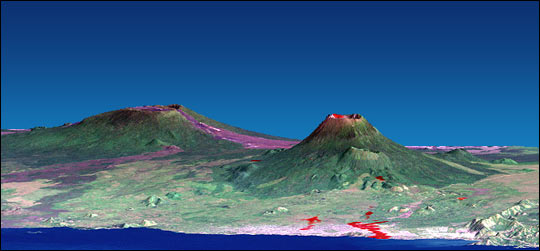
This computer-generated visualization combines a Landsat satellite image and an elevation model from the Shuttle Radar Topography Mission (SRTM) to provide a view of Nyiragongo Volcano (right of center) and the city of Goma (pink area along shoreline in foreground), located in the Democratic Republic of Congo. Additionally, image data from the Advanced Spaceborne Thermal Emission and Reflection Radiometer (ASTER) on NASA’s Terra satellite supplied a partial map of the recent lava flows, shown in red. (Image courtesy of SRTM Team NASA/JPL/NIMA, Advanced Spaceborne Thermal Emission and Reflection Radiometer, and Landsat 7 Science Team) Click here for more information. |
||
 |
|||
|
Poland explained that an earlier Nyiragongo eruption, in 1977, formed a fracture system that led partway down to the city of Goma. “Then, during the 2002 eruption, that fracture system was reactivated, and the flowing magma propagated the fractures closer to the city. The lava actually flowed right down Main Street—right through the business district,” he said. According to Poland, seeing deformation across the entire rift zone suggests that the Nyiragongo eruption was no small event; it was a major tectonic episode. “We believe there must have been a large event that allowed magma stored high in the volcano to drain into the old fracture system and head downhill,” he said. “The implication is that you can have a lot of lava come out in a very bad place—like right above your city—with very little warning.” Twice in the past 30 years, Nyiragongo’s lava flowed along the fracture system on the south flank, and this flow path leads right to Goma. “If we can start using InSAR data to monitor deformation, we might be able to better assess the likelihood of eruption events before they happen,” Poland said. |
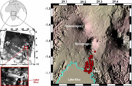
MODIS acquired an image of Nyiragongo Volcano in the Democratic Republic of Congo, Africa (location shown top left, satellite image shown middle left) on January 17, 2002, less than one hour after the eruption began. The red box in the middle left image (which indicates the area enlarged at bottom left) shows an eruption plume that extended 200 kilometers west from Nyiragongo. The town of Goma is located on the edge of Lake Kivu (indicated by red arrow). |
||