
A Demanding Model |
|||
Today’s Numerical Weather Prediction (NWP) models are mind-bogglingly complex. In the models, the basic physical laws by which the atmosphere operates—things like Newton’s first law of motion (force equals mass times acceleration), and the law of conservation of energy (energy cannot be created or destroyed, it can only change form)—are expressed as an interrelated web of mathematical equations. These equations describe the state of the atmosphere—everything from temperature, to humidity, to wind speed, to convection—at a given point in time for tens of millions of locations in the atmosphere. “To predict the future state of the atmosphere, we have to feed the model with information on the current state of the atmosphere,” says Bormann, which is where observations like the MODIS polar winds come into the story. Determining the current state of the atmosphere is itself a complicated task. Meteorologists today have to find a way to deal with the hundreds of thousands of observations now available to them through satellites, ground-based weather stations, ocean buoys, aircraft, and weather balloons. |
|||

During the 12 hours between model forecast runs at ECMWF, other computer programs churn away at the task of bringing together, or assimilating, the information from all these sources into a single batch of information on the atmosphere’s current condition. The results of the assimilation serve as the initial conditions for the next model forecast. This ‘state-of-the-atmosphere analysis,’ which the modelers call simply the analysis, involves a cycle of comparisons between forecasted and actual atmospheric conditions at various intervals during the 12-hour data assimilation window. “At the start of the 12-hour cycle, we create a short-term forecast based on the atmospheric conditions from the previous analysis,” explains Bormann. “We compare that short-term forecast to the new observations that are coming in, and look for differences. We use the differences that we see to go back and make adjustments to the previous forecast. This is done for all the observations we have for the time window.” At the end of the 12-hour period, all the adjustments are added together to produce a new analysis, a new set of initial conditions to put into the model. But Why Not Start Fresh?Why do they use 12 hours worth of observations instead of just using only the most recent observations available at the starting time of the forecast run? Scott Braun, a weather modeler at NASA’s Goddard Space Flight Center, explains the reason with an analogy. “Imagine the state of the atmosphere at a certain point in time as a cork bobbing straight up and down on the surface of the water. If you use only observations from one point in time, then all you know about that cork’s behavior is what you see right then. Imagine if, before you started looking at the cork, someone had reached beneath the surface and pulled it down underwater and then released it. The cork would have bobbed about wildly for a while before settling down into the pattern you observed, but you would never have known it.” Who knows how that cork might have influenced its surroundings while it was bobbing wildly about? It’s the same with the atmosphere. It makes a difference to the weather prediction model whether the current atmospheric conditions that are about to be fed into the model result from a stable, uneventful set of atmospheric conditions, or whether it is merely a snapshot in time of a highly turbulent atmosphere in a state of flux. In other words, when you want to get the best estimate of the state of the atmosphere, it is important to know how the atmosphere behaved over some time span. |
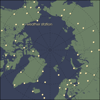
Satellite observations augment the direct observations made by weather stations scattered across the Arctic. The remote sensing data fill in the gaps, both between stations and between model runs. (Map by Robert Simmon, based on data provided by Jeff Key and Online Map Creation) | ||

It makes sense to use all the observations that come in the 12 hours between model runs, after all, those are the “real” data. But why should the modelers bother to go back and adjust the previous forecast? Why don’t they just cut their losses, and start over fresh every 12 hours? They don’t because all the observations available at the time of any forecast aren’t enough to fill the model’s incredible appetite for input. The weather prediction model wants up to eight million data points on the state of the atmosphere at any given time in order to predict how those characteristics will interact with one other to create the next day’s or week’s weather. What do the modelers do when there aren’t enough real-world observations to fill all the slots? They use the predicted values from previous forecasts. In other words, they use the model to feed the model. “If we were not using the old forecast, we would be throwing away information on the atmospheric state, and that wouldn’t be very smart if you’re already a little short,” jokes Bormann. Instead, it makes more sense to tweak the previous forecast and use the updated predictions to fill in as many observational holes in the model as they can. The value of MODIS data from CIMSS was that they filled a lot of the observational holes in the part of the model that deals with polar winds. |
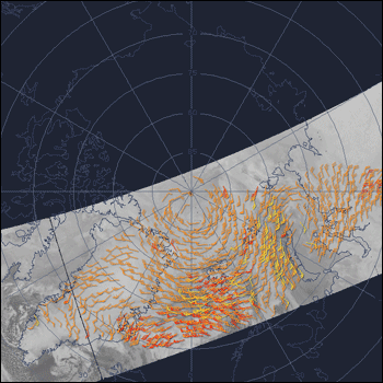
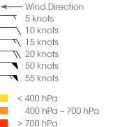
 MODIS-based estimates of wind speed and direction provide input for models where direct observations are lacking. This image shows MODIS-based wind estimates at low (yellow), medium (orange), and high (red) altitudes over the Arctic. The animations show how the winds at the three altitudes change over the course of the day between December 1 and 2, 2004. |