A Decade of High-Flying Radar |
Remote sensing of volcano topography took off in the early 1990s with the
launch of several satellites carrying radar-mapping instruments. Radar sends
rapid pulses of electromagnetic waves to the Earth’s surface and carefully
times the return of the faint signals that bounce off the surface. Each returned
signal yields a precise measure of the distance from the satellite to a point on
Earth. These measured distances are combined into digital elevation maps that
show the topography of the land surface. The wavelengths that the radars use
pierce clouds and fog and can take measurements night and day. |
||
 With an advanced technique called radar interferometry, two radar images are taken of the same area from slightly different angles. When combined they show subtle differences in elevation. This technique is capable of mapping surface features as small as 10-25 meters across and 2-5 meters deep. The first civilian spaceborne imaging radar was launched in 1978 on NASA’s short-lived Seasat spacecraft, which was lost after less than a year. The launch of the European Remote Sensing (ERS-1) satellite in 1991 returned radar to space. It was followed by a twin spacecraft (ERS-2), the Japanese Earth Resource Satellite (JERS-1), and the Canadian Radarsat. NASA flew an Earth-mapping radar on two space shuttle flights in 1994. The Spaceborne Imaging Radar C/X-band Synthetic Aperture Radar (SIR-C/X-SAR) mapped Mt. Pinatubo in April and October, providing topographic maps of lahar deposits at the beginning and end of that year’s wet season. The SRTM mission was an upgrade of this radar system. Radar maps of volcanoes have also been made by aircraft over small areas. The
Topographic Synthetic Aperture Radar (TOPSAR) instrument flew aboard a NASA
research aircraft in November 1996 to map Pacific Rim volcanoes including parts
of Mt. Pinatubo. TOPSAR produced very detailed topographic maps with surface
features just 10 meters across and as shallow as 2 meters deep. |
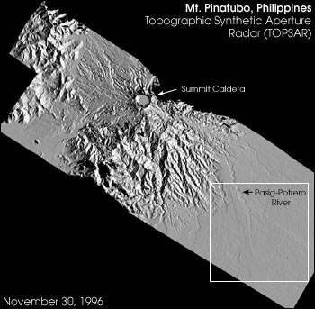
The most detailed digital elevation maps of Mt. Pinatubo produced to date were made by the Topographic Synthetic Aperture Radar (TOPSAR) instrument flown in November 1996 on a NASA aircraft. The area inside the white box was the site of damaging lahar flows. The image below shows this area in more detail. (Image courtesy Peter Mouginis-Mark and Harold Garbeil, University of Hawaii at Manoa) | ||
 With a single digital topographic map of a volcano, scientists can identify potential hazards from lava flows and lahar flows, information that can be used to advise local authorities on specific hazardous areas. With two radar maps of the same area taken some time apart, researchers can measure how much the topography has changed and calculate how much volcanic material has moved downstream. After the same TOPSAR radar flies over Mt. Pinatubo again this spring, Mouginis-Mark hopes to produce a "topographic difference" map by subtracting one image from another to see how the lahar deposits have changed in four years. "By measuring this ‘sediment budget’ we hope to be able to say when the upper slopes are stable and the risk to people downstream is decreased," says Mouginis-Mark. Torres is using data from the two 1994 space shuttle flights to study the location of lahar hazards along the Pasig-Potrero river system on the eastern flank of Mt. Pinatubo. Although these radar maps can only pick out features about 25 meters across and vertical features are nearly imperceptible, preliminary results from this work show good agreement between the landscape changes seen from space and those surveyed on the ground. Torres plans to use the more detailed maps from this spring’s TOPSAR airborne radar flights to locate flood-prone areas adjacent to river beds that have been raised by lahar sediments.
|
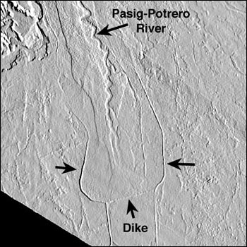
This high-resolution TOPSAR map, taken in 1996, shows the spread of lahar sediments upstream of a manmade dike built on the Pasig-Potrero River. (Image courtesy Peter Mouginis-Mark and Harold Garbeil, University of Hawaii at Manoa) |
