
HoneybeeNet | |||
“In my mind, the data from a network of hive scales would be an essential addition to ecosystem models,” Esaias concludes. “If we want to relate models and satellite data to something as tangible as food for people and wildlife, if we want to be able to predict where the thousands of species that occupy ecosystems today will survive in the future, we need to monitor when that plant-pollinator interaction is occurring.” “The best part,” Esaias says excitedly, “is that the observers we need are already out there! The bees are already collecting these data for us.” About half of the approximately 6 million honeybee colonies in the United States are kept by individual or family-scale beekeepers. Esaias’ vision is to develop a how-to guide, an automatic data recorder, and the computer and networking resources at Goddard Space Flight Center that would be needed to collect and preserve the data. Ideally, a hive data recorder would be hooked up to the Internet so that volunteers’ hive weights could appear on a Website hosted at Goddard. His goal is to get the cost per kit below $200 and then to get NASA funding to outfit a network of volunteers—HoneybeeNet—and analyze their data. “Ultimately, what we’d like to have is thousands of these across the country. Even if we can get the cost down to $200 a piece, that is still a lot of money to ask for until you have a test data set that proves it is valuable,” admits Esaias. He’s been working with local bee clubs in Maryland, rounding up some 20 volunteers who already have or are willing to purchase their own scales. He hopes that the data collected during the 2007 spring-summer season will be a prototype that will convince NASA to fund a pilot project. In the meantime, he and several colleagues at NASA, the Department of Agriculture, and several U.S. universities submitted a proposal to NASA to integrate satellite, hive data, and the results from ecological models into an early-detection system operated by the U.S. Geological Survey that monitors the spread of invasive species. By using satellite data on landscape and vegetation type along with honeybee hive data, they hope to improve predictions of the spread of the African honeybee, an aggressive and unpredictable species of bee that is colonizing the southern United States. |
|||

In addition, satellite and ecological model information on vegetation could help scientists pin down the cause or causes of colony collapse disorder. Beginning in the winter of 2006-07, hive keepers across the country began to report wintertime losses of 30 to 90 percent of their colonies. The adult worker bees seem to simply abandon the hive, including a seemingly healthy queen, immature bees, and remaining honey. As of summer 2007, scientists were still investigating numerous possible causes, including pesticides and diseases. Added stress on colonies from climate-related environmental change may be contributing, too. “I have no idea how it’s all going to turn out, but we’ll see,” he says. “I don’t know if I’ll ever go back to ocean studies. Honestly, I’m having a lot more fun. And, really it’s not that different from what I was doing before. Of course, terrestrial ecosystems are very different from marine ecosystems, but conceptually, my focus hasn’t changed—I’m still interested in the factors that influence the abundance and distribution of organisms, only now it’s bees and plants instead of phytoplankton.” He feels a sense of urgency about getting the HoneybeeNet going now. “All I can say right now is that much of what is in the [scientific] literature about the dates of the Maryland nectar flow is wrong; it’s obsolete data. We are headed into an era of global change across the country, and we don’t even know where we are starting from! How are we possibly going to predict change? If we don’t get on board quick, we’re gonna miss the boat.”
|
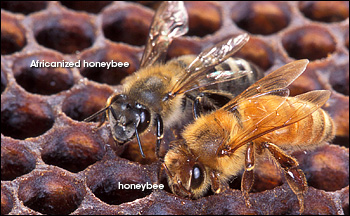
Introduced to South America several decades ago, the African honeybee is more aggressive than the European honeybee. Esaias hopes that hive data on nectar flows will improve predictions of where the African honeybee and “Africanized” hybrids will spread in the United States. (Photograph courtesy Scott Bauer, Agricultural Research Service.) | ||