The Earth Observatory has published its last Image of the Day on this website. Please join us on our new home at science.nasa.gov/earth/earth-observatory.
Some Important Clues But, if these tracer models are accurate, then shouldn’t we see obvious places above 40°N latitude where
all this carbon is accumulating? Scientists estimate that while the boreal forest occupies about 21
percent of the Earth’s forested land surface and contains 13 percent of all the carbon stored in
"biomass" (or living matter), it holds about 43 percent of all of the world’s carbon that is stored in
soil (Sellers et al. 1997). |
|||
 "For the past 7000 years, the
boreal forest floor has been accumulating carbon at a rate of about 30 grams (or roughly 1 ounce) per square
meter per year," observes NASA’s Forrest G. Hall, physicist and BOREAS project scientist. "When you walk
through the Canadian boreal forest, you can literally go from ankle deep to in over your head in carbon
litter. In some places where there were once holes or ravines, we have measured peat several meters deep." "For the past 7000 years, the
boreal forest floor has been accumulating carbon at a rate of about 30 grams (or roughly 1 ounce) per square
meter per year," observes NASA’s Forrest G. Hall, physicist and BOREAS project scientist. "When you walk
through the Canadian boreal forest, you can literally go from ankle deep to in over your head in carbon
litter. In some places where there were once holes or ravines, we have measured peat several meters deep."
Thirty grams doesn’t seem like much–it is roughly equal to the amount of carbon contained in a paper napkin. But when you multiply that 30 grams per square meter by the roughly 16 to 20 million square kilometers that comprise the total area of the boreal forest, you find that the boreal ecosystem has been taking in an average of 0.6 billion metric tons of carbon per year for roughly the last 7000 years. But carbon uptake varies from year-to-year. Scientists speculate that the boreal forest could have increased its rate of carbon intake in recent decades. "The amount of uptake depends upon the type of forest, its location, and its age," Hall explains. "During the BOREAS experiment we saw some kinds of forest (aspen) taking up 200 grams of carbon per square meter, per year." Mystery solved, right? Not so fast. Although there is plenty of circumstantial evidence, scientists need more data before they can make any firm conclusions. Moreover, they must collect these data over a large region through multiple years if they are to succeed in their mission to understand the role of the boreal forest in the global carbon cycle. Technically, we know that the boreal ecosystem is both a sink ("storage area") and a source of carbon, as it both absorbs and releases carbon dioxide. However, what scientists really want to determine is whether the boreal forest is anet sink or anet source for carbon; and how this determination depends on climate. In other words, after all the additions and subtractions of carbon dioxide, does the boreal forest as a whole retain more carbon than it releases, or vice versa? "We won't know until we add up the contributions from all the kinds of forest that make up the boreal
ecosystem," Hall states. "That will require satellite-derived maps of the entire circumpolar boreal
region that enable us to sort out the different types of forests and assess their productivity." |
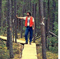
Boardwalks allowed Dave Landis and other scientists to move between the research stations without sinking into the soft, wet soil. For most of the year waterlogged soil and cool temperatures prevent forest detritus — fallen needles, leaves, and branches — from decomposing. (Photograph courtesy BOREAS project) |
||
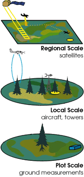
| The BOREAS Measurement Strategy In planning the BOREAS experiment, researchers had two main objectives: (1) improve their understanding of how the boreal ecosystem exchanges radiant energy (sunlight and heat), water, and carbon with the atmosphere; and (2) develop better computer simulation models that in the future will enable scientists to measure and even predict changes in the boreal ecosystem using satellite and other forms of meteorological and environmental data. In order to meet their objectives, BOREAS scientists selected two large regions, about 500 kilometers apart, in the Canadian provinces of Manitoba and Saskatchewan. Over a period of four years (1994-97), and in each season of the year, they made local-scale measurements on the ground and in towers that stand high above the forest canopy. The BOREAS team complemented these leaf-scale and local-scale measurements with regional- and large-scale measurements made by remote sensors aboard aircraft and satellites. They continually cross-compared data from these various instruments to make sure they agreed. "I think that our strategy was remarkably successful," Wofsy observes. "The people who organized the BOREAS experiment did a wonderful job." Piers J. Sellers and Forrest Hall, of NASA’s Goddard Space Flight Center, were primarily responsible for the design and oversight of the BOREAS operations.
|
|