

It’s been six years since the CYGNSS constellation was launched. Over that time, it has grown from a two-year mission measuring winds in major ocean storms into a mission with a broad and expanding variety of goals and objectives. They range from how ocean surface heat flux affects mesoscale convection and precipitation to how wetlands hidden under dense vegetation generate methane in the atmosphere, from how the suppression of ocean surface roughness helps track pollutant abundance in the Great Pacific Garbage Patch to how moist soil under heavy vegetation helps pinpoint locust breeding grounds in East Africa. Along with these scientific achievements, CYGNSS engineering has also demonstrated what is possible with a constellation of small, low cost satellites.
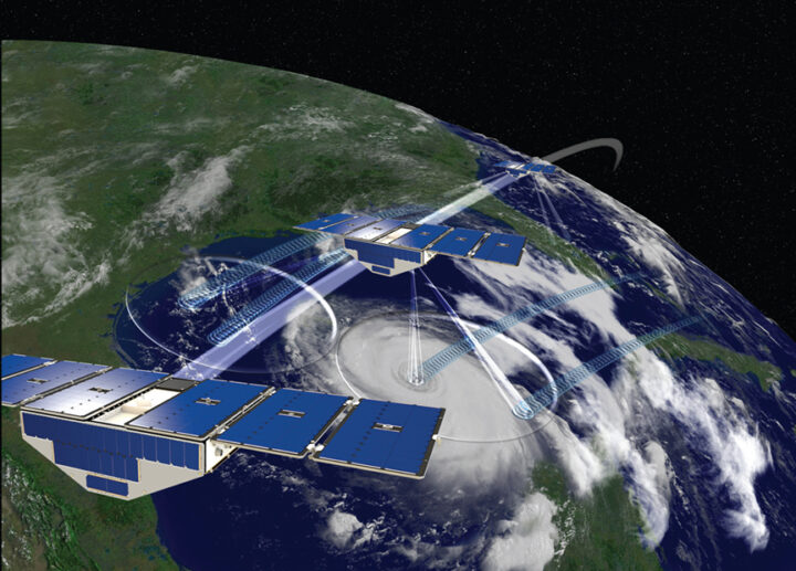
As our seventh year in orbit begins, there is both good news about the future and (possibly) bad news about the present. First the bad news. One of the eight satellites, FM06, was last contacted on 26 November 2022. Many attempts have been made since then, but without a response. There are still some last recovery commands and procedures to try, but it is possible that we have lost FM06. The other seven FMs are all healthy, functioning nominally and producing science data as usual. It is worth remembering that the spacecraft were designed for 2 years of operation on orbit and every day since then has been a welcomed gift. I am extremely grateful to the engineers and technicians at Southwest Research Institute and the University of Michigan Space Physics Research Lab who did such a great job designing and building the CYGNSS spacecraft as reliably as they did. Let’s hope the current constellation continues to operate well into the future.
And finally, the good news is the continued progress on multiple fronts with new missions that build on the CYGNSS legacy. Spire Global continues to launch new cubesats with GNSS-R capabilities of increasing complexity and sophistication. The Taiwanese space agency NSPO will be launching its TRITON GNSS-R satellite next year, and the European Space Agency will launch HydroGNSS the year after. And a new start up company, Muon Space, has licensed a next generation version of the CYGNSS instrument from U-Michigan and will launch the first of its constellation of smallsats next year.
The CYGNSS team will continue to operate its constellation, improve the quality of its science data products, and develop new products and applications for them, with the knowledge that what we develop now will continue to have a bright future with the missions yet to come. Happy Birthday, CYGNSS!
The CYGNSS constellation of 8 SmallSats was launched into low Earth orbit five years ago, on December 15, 2016. It began as a two year mission to study how well GPS signals reflected from the ocean surface can help us measure the winds in hurricanes and improve our ability to forecast them. Well, we’ve done that, but it turns out those reflected signals can tell us a lot more. One of the key reasons we’ve been able to learn about all the other applications is the extra time we’ve had on orbit, to make more measurements, study their sensitivity to other environmental parameters, construct new data products, and develop scientific uses for them. For that, I am sincerely grateful to the team of technicians, engineers and managers at the Southwest Research Institute and the Space Physics Research Lab who designed, built, tested and now operate the spacecraft, and to our partners at Surrey Satellite Technology Ltd. who designed and built the GPS receivers that take our science measurements. They were given a schedule, a budget and a two-year requirement for on-orbit operations. We got to orbit on time and under budget and here we are, five years later, still making high quality observations with each GPS receiver on every spacecraft at 100% duty cycle. I am also very grateful to NASA for the support they have provided and for their willingness to expand the scope of CYGNSS science as we discover new, exciting and impactful things we can do with our mission.
One of the great things about operating 8 spacecraft with a 100% duty cycle is the frequency with which you can sample tropical cyclones throughout their entire life cycle. This is illustrated in the following figure, which shows when and how well CYGNSS sampled every major storm (Cat 3 or greater) from 2018 to 2020.
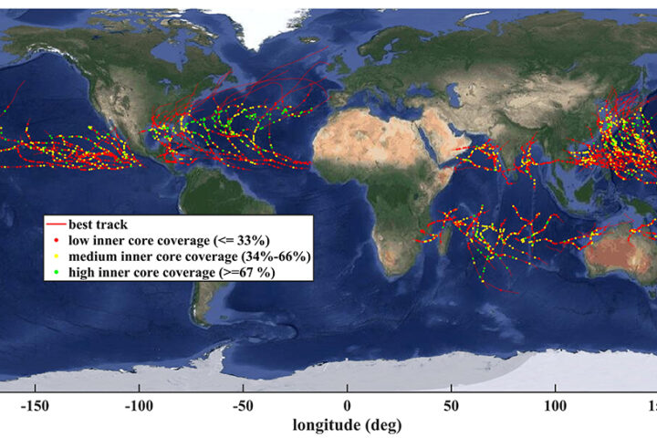
In the figure, the red lines are the track of each storm throughout its life cycle, the dots are when there was a CYGNSS overpass, and the color of the dot indicates how well we sampled the inner core of the storm. Every storm is sampled between one and three times a day, which helps monitor its development and capture sudden changes like rapid intensification. The impact our observations have on hurricane forecast skill is an active area of research by the CYGNSS science team. One recent example is work by researchers at the NOAA Hurricane Research Division that is highlighted in this figure.
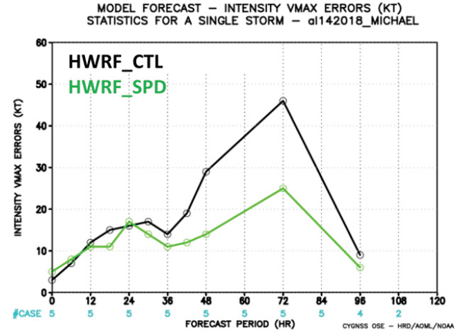
The figure shows the error in the operational forecast of maximum wind speed during Hurricane Michael’s rapid intensification, which occurred between 36 and 72 hours into the forecast (black line), and the reduced error that would have been present had CYGNSS observations been included (green line). The peak error is reduced from about 45 to 25 knots, or cut almost in half.
CYGNSS spends much less than 0.1% of its time over hurricanes but its radar receivers operate continuously. This enables many other uses of the data. Data products over ocean include near-surface wind speed and, from it, sea-to-air fluxes of latent and sensible heat. One new data product released in 2021 is the concentration of ocean microplastics, derived from the suppression of ocean surface roughness by surfactants acting as tracers of the microplastics. Time lapse microplastic concentration maps of Yangtze River outflow are shown in the following figure.
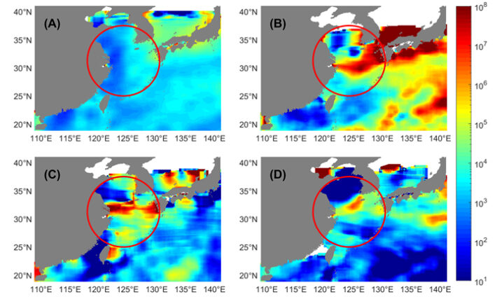
The upper left panel (A) in the figure shows the annual average microplastic concentration in the East China Sea near the mouth of the Yangtze. There is no obvious outflow signal. Panels (B)-(D) show the concentration averaged over individual weeks of the year in which there is a prominent outflow plume.
CYGNSS operates over both ocean and land, and the land reflections contain two important pieces of information. When standing water is not present in the measurement footprint to any significant degree, it is possible to retrieve near-surface soil moisture content. We can measure the global distribution of soil moisture several time per day and those data have been shown to significantly improve global land surface hydrology models <https://doi.org/10.1088/1748-9326/ac0ddf>. When inland water bodies are present in the footprint, reflections from them tend to dominate the measurements. CYGNSS is then able to effectively map the extent of the water. One application of this capability is shown in the following figure of flood inundation across the island of Hispaniola as imaged by CYGNSS after Hurricane Isaias landfall.
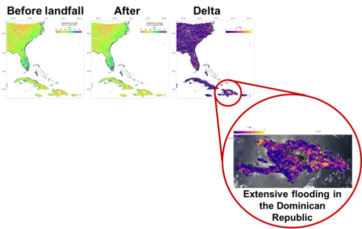
The “Delta” map shows the change in surface reflectivity from before to after landfall. The extensive flooding that occurred in the capital city of Santo Domingo is highlighted by bright yellow (high delta) areas.
Inland water body maps produced by CYGNSS have two distinct properties. One, which derives from the large number of satellites in the constellation, is their ability to be updated often. This allows them to capture sudden changes like flood events. The other, which derives from the use of GPS signals that can penetrate through clouds, rain and vegetation canopies, is their ability to map wetland extent in heavily vegetated regions. One exciting new application of this capability is improved prediction of methane emission from wetlands. The accuracy of a global wetland methane emission model was evaluated when initialized by three different water masks. The results are shown in the following figure.
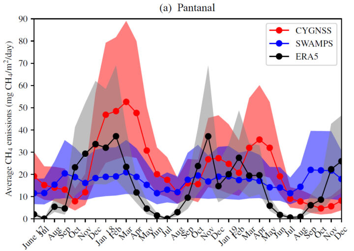
If a static water mask derived from Vis/IR imagers is used (SWAMPS blue curve in figure), seasonal variations in water extent are not represented and anomalous conditions associated with clouds and vegetation are misrepresented. If the model uses a dynamic rainfall map to better account for seasonal effects (ERA5 black curve), complications in the relationship between rainfall and wetland inundation are neglected. The best results are had using dynamic maps of wetland extent derived from CYGNSS observations (CYGNSS red curve) because they are based on direct, time varying measurements of the inundation that are insensitive to clouds and vegetation.
The first five years of on-orbit operation have produced valuable ocean wind observations for improved hurricane forecasting and have uncovered many new applications of the data away from hurricanes. We will continue to refine our measurements of winds, soil moisture and inland water bodies. And who knows what other new sensitivities we will uncover in the next five years?
NASA recently completed its senior review process for Earth science missions and CYGNSS has been approved to continue science operations through 2023. Another senior review will occur then. The constellation of eight spacecraft are healthy and operating nominally in their orbits 524 kilometers above the Earth. They continue to make 24/7 measurements of ocean surface winds, both globally and in tropical cyclones, to help understand meteorological processes and improve numerical weather forecasts. Over land, measurements of flood inundation, water body extent, and soil moisture are used in hydrological process studies and for disaster monitoring.
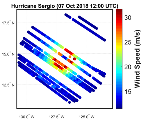
Our ability to forecast the strengthening of hurricanes has been improved by CYGNSS measurements of their inner core winds, which allow us to track the transfer of energy from the warm ocean water into the atmosphere in the form of latent heat flux. Currently, CYGNSS data are being used in re-analysis investigations; that is, revisiting old hurricane forecasts with new CYGNSS data added to see how the predictions are improved. Eventually, the goal is to use the data directly in operational forecasting by NOAA’s National Hurricane Center. CYGNSS wind observations can also be used to provide better estimates of the location of the hurricane, as reported in 2019 in the Journal of Applied Meteorology and Climatology.
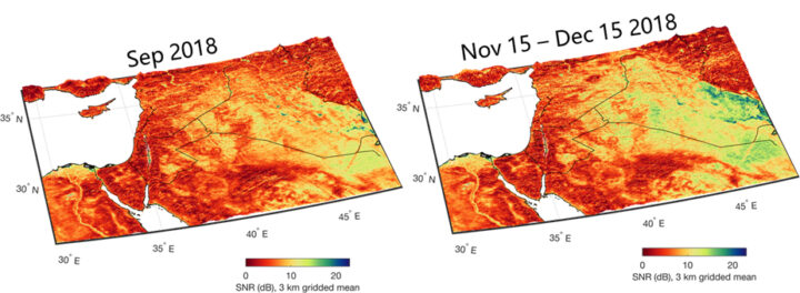
Measurements by CYGNSS over land are used to determine soil moisture content under dense vegetation. This, in turn, allows for the identification of conditions conducive to major locust outbreaks in East Africa. Locating locust breeding grounds before the insects are mature and able to fly provides a unique opportunity for eradication efforts on the ground. This capability is being investigated through a partnership between members of the CYGNSS science team, NASA SERVIR, the U.S. Agency for International Development (USAID), and the United Nations Food and Agriculture Organization (FAO). For more information, refer to this Image of the Day published in March 2020.
With NASA’s continued support, CYGNSS will be able to continue with its investigations supporting a better understanding of and ability to forecast tropical cyclones, and to expand its investigations into novel applications over land.
CYGNSS was launched on December 15, 2016 at 13:27:21 UTC and today marks the completion of its third year on orbit. Much has happened in that time and the future looks very promising, with all eight microsatellites healthy and operating continuously in their nominal science data-taking mode. Year 1 was spent on engineering commissioning and initial ocean wind measurements. In year 2, the ocean wind retrievals were refined and characterized and investigations of observations over land began in earnest. This past year has seen progress on several fronts. An important refinement to the engineering calibration has been developed. Ocean wind measurements in tropical cyclones have been successfully introduced into numerical hurricane forecast models. And the ability to image inland waterbodies with high resolution has been leveraged to demonstrate two new measurement capabilities.
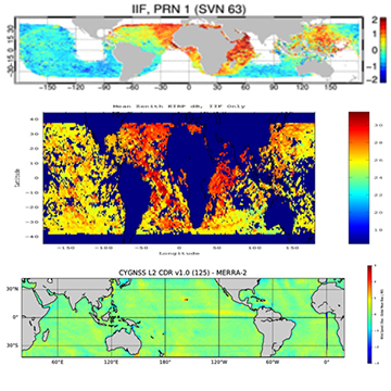
CYGNSS measures the strength of GPS signals reflected by the Earth surface, from which properties of the surface are derived. To do this accurately requires knowledge of the signal strength transmitted by the GPS satellite. The original approach to calibration assumed each GPS satellite had a unique transmit power level and that it did not vary in time. The unique power levels were estimated using measurements averaged over several months. Subsequent analysis has revealed that GPS transmit power can vary significantly, depending on the particular satellite and on its position in orbit. In order to compensate for the changes, the direct signal GPS receivers on all eight CYGNSS satellites were reprogrammed in 2018 to act as power meters which can monitor the variations in transmit power [Wang et al., 2019. A Real-Time EIRP Level 1 Calibration Algorithm for the CYGNSS Mission using the Zenith Measurements. Proc. IGARSS 2019]. The impact of this change is illustrated in the following figure. The top panel shows the geographical distribution of the average error in CYGNSS wind speed for a single GPS transmitter (SVN 63) assuming its transmit power is constant. The center panel shows the actual GPS transmit power as measured by the new on-board monitoring system. Clear localized differences in the measured power are evident which correlate with the errors in wind speed. The bottom panel shows the distribution of average wind speed error after the monitored power is incorporated into the calibration. The discrepancies have been largely removed.
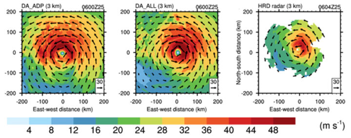
Over the past year, CYGNSS ocean wind measurements have been added to the HWRF numerical forecast model used by the National Hurricane Center and compared to the standard operational forecast, which does not yet use CYGNSS. To forecast a hurricane, HWRF is first initialized with satellite, airborne, and ground based measurements. The storm is then allowed to develop in software, guided by underlying physical principles of thermodynamics, radiation and mass and energy conservation. An example of this is shown in the following figure, which presents three versions of the horizontal wind speed at 3 km altitude for Hurricane Harvey on 25 Aug 2018 at 06Z. The left panel is the 24 hr forecast predicted on 24 Aug by the operational version of HWRF without CYGNSS data. The center panel is the HWRF prediction with CYGNSS winds included. Note the azimuthal shift in predicted peak winds into the northeast quadrant when CYGNSS winds are included. The right panel shows measurements made by NOAA’s airborne doppler radar of the actual winds at 3 km. The predicted azimuthal shift is confirmed, suggesting that the storm’s development is being more accurately modeled [Cui et al, 2019. A Preliminary Impact Study of CYGNSS Ocean Surface Wind Speeds on Numerical Simulations of Hurricanes. Geophys. Res. Ltrs.].
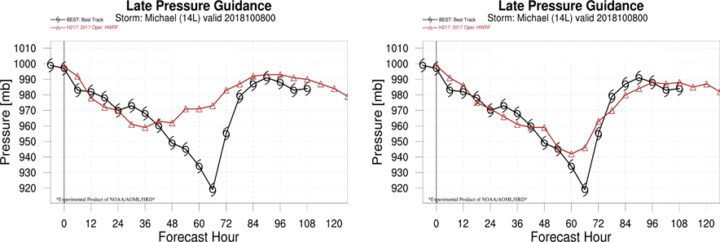
More accurate modeling of storm development should help forecast the intensity of its surface winds, and this has been demonstrated by another study using HWRF [Annane et al., 2018. Impact of CYGNSS Data on Tropical Cyclone Analysis and Forecasts Using the Operational HWRF. 33rd AMS Conf. Hurricanes Trop. Meteo.]. In this case, a 120 hr forecast of minimum sea level pressure (MSLP) in the eye of Hurricane Michael was conducted on 8 Oct 2018 at 00Z without and with CYGNSS winds included as one of the inputs. The left panel in the following figure shows the true (best track) MSLP in black and the operational forecast (without CYGNSS) in red. The rapid drop in MSLP that occurred between ~30-60 hr is not well forecast. The right panel shows the HWRF forecast with CYGNSS winds included and can be seen to more accurately predict the rapid intensification of the storm.
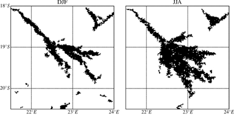
CYGNSS measurements over land are able to provide high resolution tracks across inland waterbodies when the surface is calm enough to support coherent specular scattering. A new land/water mask has been developed which leverages this capability as well as the ability of CYGNSS to penetrate through clouds, rain and vegetation canopies. As a result, dynamic changes in waterbodies (e.g. due to flooding, seasons or human development) can be resolved better than existing water masks that rely on optical satellite imagers. [Gerlein-Safdi and Ruf, 2019. A CYGNSS-Based Algorithm for the Detection of Inland Waterbodies, Geophys. Res. Ltrs.]. An example of this new capability is shown in the seasonal watermasks of the Okavango Delta in Botswana derived from CYGNSS overpasses in 2018. The left panel, for Dec/Jan/Feb, shows the typical river boundaries that are present during the dry season. The mask in the right panel, for Jun/Jul/Aug, captures the widespread flooding which occurs during the rainy season.
CYGNSS overpasses of rivers also produce high resolution tracks that can be used to measure a river’s width and infer its streamflow rate. This has been successfully demonstrated using overpasses of the Pascagoula River in Mississippi during a major flood event in April 2019 [Warnock and Ruf, 2019. Response to Variations in River Flowrate by a Spaceborne GNSS-R River Width Estimator, Remote Sens.]. Streamflow measurements by a USGS river gauge made before, during and after the event are shown in the upper panel below, together with markers at the times of each of five overpasses by CYGNSS. The lower panel shows the Associated GNSS-R Width (AGW) of the river derived from each CYGNSS overpass, together with the Pascagoula’s streamflow rate at the time.
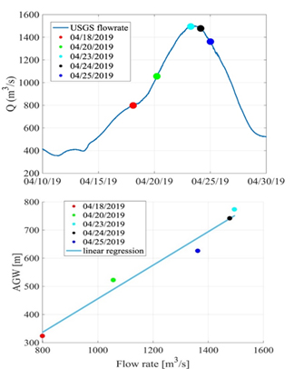
The two are highly correlated, suggesting that another new type of CYGNSS data product may be possible over inland waterbodies.
The constellation of eight CYGNSS microsatellites reached a milestone today, completing its second year on-orbit. The first year had focused primarily on engineering commissioning, calibration and early validation of the science data products. The second year was spent continuing to refine and improve the quality of the science data products, while also applying the measurements to a number of scientific investigations. Some examples of the refined wind speed measurements are shown below for three overpasses of Hurricane Maria, on 23 Sep 2017 at 00:18 (top), 23 Sep 2017 at 00:23 (mid), and 24 Sep 2017 at 00:18 (bot).
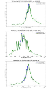
Coincident hurricane overpasses by CYGNSS and NOAA hurricane hunter aircraft
In the figure, the green trace shows the measurements made by CYGNSS while the blue trace shows measurements made by SFMR instruments on the NOAA hurricane hunter aircraft that flew into the storms while CYGNSS was passing overhead. The CYGNSS and SFMR measurements can be seen to agree quite well. Quantitative results of the calibration and validation of CYGNSS science data products are described in a Special Issue of the IEEE Journal of Selected Topics in Applied Earth Observations and Remote Sensing.
Measurements by CYGNSS of Typhoon Trami in Sep 2018, shown below, illustrate its ability to track the evolution of a storm over its full life cycle. In the figure, the lower left image is a composite over the period 20-30 Sep 2018 of all wind speed measurements made at one phase of the constellation’s orbit. The upper right insert shows all measurements made on 28 Sep 2018, with the measurements re-gridded to a storm-centric coordinate system to illustrate the wind speed structure in the inner core region.
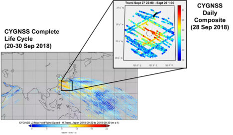
CYGNSS wind speed measurements of Typhoon Trami
Science investigations have expanded beyond the primary mission objective to measure wind speed in tropical cyclones. The measurements are being introduced into numerical weather prediction models to assess their impact on the skill in forecasting hurricane track, intensity and structure. Early results look quite promising, with clear signs of a positive impact on forecast skill. The results will be presented in a series of talks at the annual meeting of the American Meteorological Society in January 2019.
In parallel with the activity over ocean, new science investigations are examining data over land as well. CYGNSS measurements have been found to be sensitive to the surface soil moisture, and to the presence of inland water bodies. Good examples of this are documented in recent publications. Kim and Lakshmi (2018) [doi:10.1029/2018GL078923] estimate soil moisture at numerous sites in the continental U.S. over a 12 month period and find close agreement with independent measurements made by ground sensors and another satellite. Jensen et al. (2018) [doi:10.3390/RS10091431] demonstrate the ability of CYGNSS to detect and map the extent of flood inundation under dense forest canopies. Chew et al. (2018) [doi:10.1038/S41598-018-27673-3] use this capability to produce time lapse images of flooding in and around Houston and Havana after landfalls by Hurricanes Maria and Irma, respectively. These results demonstrate the wide range of future applications of CYGNSS data as the mission moves forward into its third year.