After our adventures in Quebec and Greenland, it was now time for our last stop in this intense season of fieldwork. This time we were heading to the Canadian Northwest Territories (NWT). Extraordinary wildfire seasons have become a regular occurrence in the NWT. The territory’s 10-year average for the total number of fires was exceeded in 2022, with nearly 600,000 hectares burned in 256 fires. At the time, that was more than any year since the outlier season of 2014. This may seem like a lot, but 2023 was brutal and far more exceptional.
The 2023 record fire season totaled around 3.6 million hectares burned by 303 fires. About 70 percent of the territory’s population, including the capital Yellowknife, was evacuated in the summer of 2023. The current Canadian fire season is also shaping up to be one of the most extreme in the last two decades. These extreme fire seasons have a significant impact on carbon emissions into the atmosphere. In response, our goal for this campaign was to obtain critical field observations to better estimate these emissions, so we packed our bags one last time for this summer and traveled as far north as Inuvik to begin our final data collections.
Despite the significant advances in understanding carbon emissions from boreal forest fires in recent years, there are still substantial gaps in our knowledge when it comes to high-latitude tundra fires. Field-based carbon combustion measurements from tundra fires are scarce, and although these fires have historically been less frequent than those in boreal forests, they can be substantial due to the availability of carbon-rich organic soils in these regions. Part of our team on this expedition has previous field experience with tundra fires, and we know that tussocks can be used as reference points to estimate how much of the soil organic layer was lost due to fire.
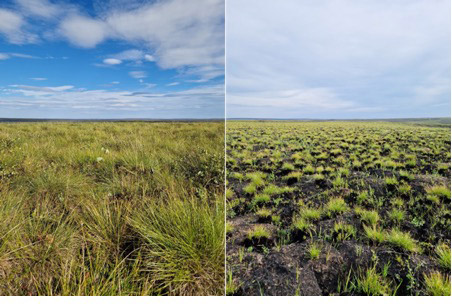
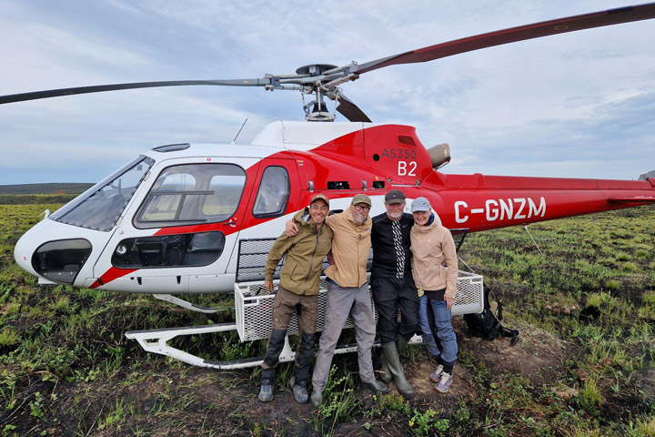
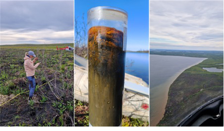
In 2023, a large tundra fire broke out near the town of Inuvik. North of the Arctic Circle, the fire is in a fairly remote area with no road or river access. So, we sampled this fire by helicopter in an effort to estimate and date carbon stocks and calculate the amount of carbon released into the atmosphere. Along the fire perimeter, we found different types of dominant vegetation in the tundra, ranging from the tussocks to shrublands and even sparsely treed areas.
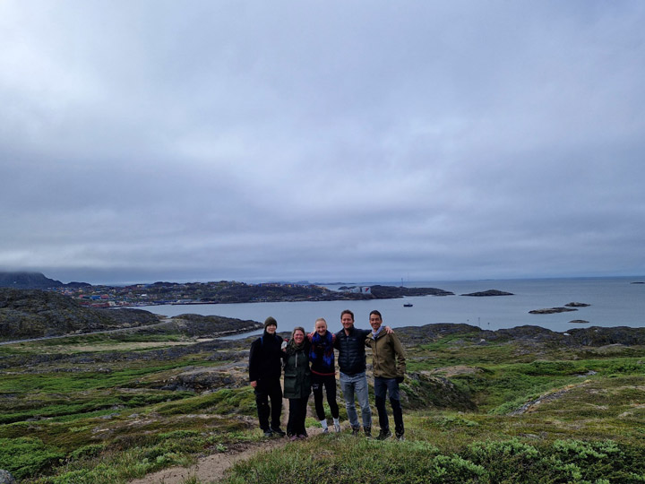
The view of the northern landscape was mesmerizing from above! The rolling hills stretched endlessly across the horizon, while the striking polygonal soil patterns and distinctive pingos added to the captivating view. The tundra was dotted with lakes of various sizes and ancient riverbeds. With paleo specialists Atte Korhola and Jan Weckström accompanying us, we couldn’t resist the opportunity to sample a lake and study the historical fire record preserved in its sediments. We are grateful to the Aurora Research Institute and the local community for welcoming us.
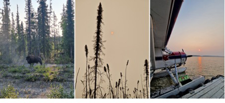
After an intense week in Inuvik, our team hit the road again, this time heading south to the Scotty Creek Research Station, about 50 kilometers from Fort Simpson. We began our journey from Yellowknife to Fort Simpson, uncertain whether the ongoing fires would allow us to travel. The smell of smoke was overwhelming, and the sight of the recently burned forest along the road was stark. Along the gravel road to Fort Simpson, we encountered bison, sampled some peatlands, and spent an hour waiting for a ferry. In the evening, we watched as the moon took on an intense red hue, tinted by the smoke particles in the air.
The next morning, we boarded a floatplane from the Mackenzie River to the Scotty Creek Research Station, where a friendly crew gave us a warm welcome. The research station is so isolated that it’s only accessible by plane. The creek, where the station is located, drains a 152-square-kilometer area of boreal forested peatland. Due to the permafrost in the region, significant thawing has transformed parts of the landscape from forested permafrost to treeless wetlands. In October 2022, the station suffered massive damage from an extraordinary late-season wildfire that raged for nearly 100 days before finally reaching the camp. The research station had just reopened during our stay there. This is good news for the entire scientific community, given the importance of this unique site in the heart of the boreal forest.
The goal of our Scotty Creek campaign was to sample the effects of fires on peatland ecosystems, aiming to better understand the climate change implications of wildfire in this fire-sensitive landscape. We spent three days in the field, sampling key ecosystems from sunrise until sunset.
A special shoutout goes to the station crew, whose professionalism made everything run smoothly. After long days of work, returning to camp was a treat, especially with our hosts preparing dinner for us. We’ll never forget their hospitality—thank you, Scotty Creek team!

And so, our journey comes to an end. It was a summer to remember, one filled with hard work but also moments of joy and discovery. People will read this post, and in the near future, others will study the findings of our field research. Our results may be cited and applied by fellow scientists. Yet, no data or paper can truly capture what this season of fieldwork was like. Only we hold those memories. The months of preparation that preceded the trip: developing research protocols, selecting sites, navigating logistics, and endless paperwork. The long hours driving both paved and dirt roads. Fieldwork under the scorching sun, and other days when cold rain chilled us to the bone. The relentless mosquitoes. Simple lunches in the field contrasted with the risotto made from mushrooms foraged at burned sites. The flat tire. The cracked car window. Lost pens. Inventorying more than 400 trees in a single plot. Charcoal covering our hands and faces day after day. Setting up camp in incredible, remote places. The joy of plunging into a cold lake after a hard day of work. Spontaneously stopping the car on our day off because the excitement of sampling two more sites was too hard to resist. Unexpectedly gaining four extra days in Greenland due to a canceled flight. Swimming in the frigid waters of a fjord. Climbing to the summit of a mountain.
We have had the privilege of visiting places most people will never see, and for that, we are deeply grateful. This chapter of fieldwork for our Ph.D. research is over, but the Arctic continues to warm, and intense fire seasons in these regions are here to stay. We are eager to better understand the complex interactions between these changes and Arctic-boreal fires. As we return home, our suitcases packed with data, the time for analyses begins—now from our offices, but with this field season always on our minds.

The NWT fires expedition was organized within the Research Council of Finland Academy Research Fellow project “Fire in the Arctic,” led by Meri Ruppel, and the Kone Foundation project FLARE. The fieldwork was also part of FireIce (Fire in the land of ice: climatic drivers & feedbacks), a Consolidator project led by Sander Veraverbeke and funded by the European Research Council. FireIce is affiliated with NASA’s Arctic-Boreal Vulnerability Experiment (ABoVE).
This blog post was co-written by Lucas R. Diaz, a Ph.D. student at Vrije Universiteit Amsterdam, and Sonja Granqvist, a Ph.D. student at the University of Helsinki, both studying Arctic-boreal fires.

A combined team from the University of Helsinki (Environmental Change Research Unit), the Finnish Meteorological Institute (Atmospheric Composition Unit), and the Vrije Universiteit Amsterdam (Climate & Ecosystems Change) was on its way again to gather groundbreaking data on carbon and aerosol emissions from increasing fires in the northern high latitudes. Our journey began in boreal Quebec and now continues to Arctic Greenland.
Climate change is warming the Arctic with partly unexpected consequences. In recent years, unprecedented wildfires have raged through Arctic permafrost terrain burning in 2019 and 2020 alone, an area equal to half of what burned in the previous 40 years. In Greenland, a land known for its icy expanse, fires are rare. However, in July and August 2019, the second-largest wildfire recorded on the island occurred at the Kangerluarsuk Tulleq, northeast of Sisimiut. To our knowledge, fire effects in Greenland have never been studied—until now, as we begin our investigation.

To estimate the carbon burned and greenhouse gases and aerosols released during tundra fires, we assess post-fire ecosystem effects. We measure the dominant ecosystem types within the fire scar and compare them with unburned areas. We evaluate fire severity, and we conduct various aboveground and belowground measurements to calculate and date carbon stores.
Our campaign aimed to efficiently use 29 hours at the destination by collecting samples from all major ecosystems within the fire scar. We arrived by boat (hiking from Sisimiut is also possible but would take 2 days) and spent the day sampling. We camped near the shore, with some of us taking a daring dip in the sea. We continued sampling the next day before returning to Sisimiut in the evening. The study area exemplified the Arctic steppe ecoregion, featuring fragmented ecosystems ranging from barren rocky slopes and drier fields dominated by moss and lichen to moderately wet peatlands. We successfully collected a diverse set of samples from various ecosystems for detailed lab experiments and analysis to be performed back in Finland.

As we were preparing to head home from Greenland, we encountered unexpected foggy weather, which led to flight cancellations for several days. This gave us a well-appreciated few extra days of adventure. Three of us packed our hiking gear and embarked on an overnight hike. The summit of the two mountains we climbed was unforgettable. A key lesson for traveling in Greenland: keep your schedule flexible—it’s worth it!
Overall, the field campaign was a unique, once-in-a-lifetime experience. But that’s not all—can you guess where the fiery journey of Granqvist and Diaz will take them next? Stay tuned!

The Greenland fire expedition was organized within the Research Council of Finland Academy Research Fellow project “Fire in the Arctic,” led by Meri Ruppel, and the Kone Foundation project FLARE. The fieldwork was also part of FireIce (Fire in the land of ice: climatic drivers & feedbacks), a Consolidator project funded by the European Research Council. FireIce is affiliated with NASA’s Arctic-Boreal Vulnerability Experiment (ABoVE). This blog post was written by Sonja Granqvist, a Ph.D. student at the University of Helsinki, studying Arctic-boreal fires in collaboration with the Climate & Ecosystems Change research group from the Vrije Universiteit Amsterdam.
This blog post is the first in a series to come. Our team, the Climate & Ecosystems Change research group from the Vrije Universiteit Amsterdam, is working in collaboration with the Environmental Change Research Unit from the University of Helsinki for a summer with lots of fire field work, science, and adventure. On this journey, our first stop was the Quebec province in Canada. I’m writing this post after our last day of fieldwork here.
The 2023 wildfire season was the largest on record in Canada, with more than double the burned area as the second largest year. In Quebec, an estimated 4.5 million hectares were burned, an area slightly larger than the size of the Netherlands. This record-breaking fire season in Quebec was due to extreme warm and dry conditions. The dense smoke plumes from the 2023 Quebec blazes shocked the world when the smoke reached several cities on the US East Coast, including New York City.
Fellow scientists have been digging deep to understand and explain the phenomena involved in this Quebec fire season. However, as far as we know, estimates of carbon combustion, or the amount of carbon per area burned that is released during a fire, have never been made in Quebec. That’s why we are on it! In loco, since field measurements are a prime way to quantify carbon emissions from fires.

We assess post-fire ecosystem effects to calculate carbon pools below and above ground. In other words, this is the carbon stored in the soil and vegetation. After collecting soil samples and inventorying the vegetation, we can compare burned and unburned (control) locations to estimate how much of this carbon was emitted to the atmosphere due to fire. We do this comparison based on what is called the adventitious root method. On black spruce trees, adventitious roots grow above the initial root collar into the upper soil layers and provide a reference for the pre-fire soil height, as they remain clearly visible many years after fire.

During our expedition, we covered more than 4,000 kilometers on the road. We started by traveling north from Montreal along the James Bay Road and began our sampling at two fires near the locality of Radisson, where the remote Trans-Taiga road was our daily route. We then headed to Waskaganish, on the southeast shore of James Bay, where we sampled another fire. Finally, we ended our campaign at a large fire in the commercial forest near the town of Lebel-sur-Quévillon. All these trips allowed us to make a scientifically interesting transect from North to South in the Quebec province. We also got to know some incredible places, and we are grateful to the people living there who welcomed us.
We were able to observe two different types of intermixed ecosystems in the fires we visited. We found forests dominated by black spruce in peaty lowlands. In drier and often rocky uplands, Jack pine trees dominated. I’m curious to see how these differences will be reflected in practice when we analyze the carbon combustion in these systems.

Our team in the campaign was Lucas Diaz, Max van Gerrevink, Thomas Janssen, Yuquan Qu, and Sander Veraverbeke from VU Amsterdam, and Sonja Granqvist from the University of Helsinki. The success of this expedition is also thanks to our collaborators here in Quebec who helped us during our preparation: Dominique Arseneault (Université du Québec à Rimouski), Jonathan Boucher and Yan Boulanger (Canadian Forest Service), and Fabio Gennaretti (Université du Québec en Abitibi-Témiscamingue).
This fieldwork is part of my PhD project, so I was responsible for leading and organizing the entire expedition. As hard as it was, the whole process was also a lot of fun. Several times during the campaign, I felt like I was on a holiday road trip with a group of friends. In the end, that’s not entirely wrong. This kind of experience brings us closer to people. It strengthens existing bonds and creates new ones. This great adventure gave me moments that I will remember forever.
Time passes quickly here in the boreal forest. Soon, it will be time to pack our bags and embark on the next stage of this fiery journey. Curious about the destination? Stay tuned!

The Quebec fires expedition is part of FireIce (Fire in the land of ice: climatic drivers & feedbacks). FireIce is a Consolidator project funded by the European Research Council. FireIce is affiliated with NASA’s Arctic-Boreal Vulnerability Experiment (ABoVE). This blog post was written by Lucas Ribeiro Diaz, a Ph.D. student at Vrije Universiteit Amsterdam, studying Arctic-boreal fires by combining field and remote sensing approaches.
“PACE is a mission that will use the unique vantage point of space to study some of the smallest things that can have the biggest impact.” — Karen St. Germain, director of NASA’s Earth Science Division
The skies above us are teeming with tiny particles of dust, sea salt, smoke, and human-made pollutants. The seas, oceans, and lakes around us are teeming with microscopic, plant-like organisms. In both cases, individual bits of these tiny living and inanimate particles are too small for your eye to see. But when billions to trillions of them aggregate in one place, we can see them from space. And these little things make a vast difference for life on Earth.
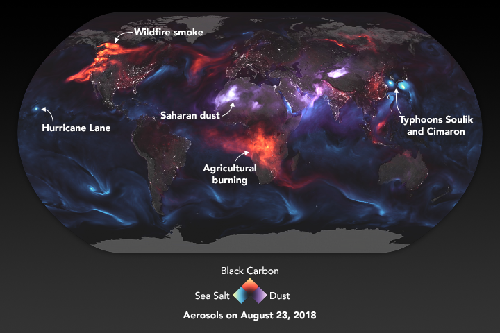
The particles in the air are known to atmospheric scientists as aerosols. Though the spray cans you might use for paint or hairspray do contain aerosols, the ones PACE will study are the flecks of carbon that rise from wildfires and smokestacks; the fine, dusty minerals that get lofted from deserts into the sky by strong winds; the nitrates and sulfates spewed by cars, trucks, and ships in their exhaust; and the salty spray from crashing waves and strong winds blowing over the ocean.
Why study them? Because those particles influence air quality, sometimes making it unhealthy to breathe, especially if you have asthma or heart and lung conditions. Pollution and smoke don’t observe borders – we all share Earth’s air — so it’s important to know something about the sources and types of particles floating around us. On the positive side, the bits of mineral dust or smoky aerosols can sometimes fertilize the ocean, providing nutrients for phytoplankton to bloom.
Aerosols also affect weather and climate. Tiny particles in the air reflect sunlight, and how much they reflect affects how much the land and ocean surfaces heat up. Aerosols also “seed” the formation of clouds: they provide surfaces on which water droplets form (condensation nucleii) as they aggregate into clouds. One of the great unknowns in our models of climate change is what role will aerosols will play in changing rainfall and snowfall patterns and in the heating or cooling of our atmosphere.
Though NASA has been studying aerosols from space for decades — observing where they are and the abundance of them — PACE and its SPEXone and HARP2 polarimeters will change the game. The instruments will tell us the shape and size of aerosols, helping us answer questions about where they come from and how they might influence other parts of the Earth system.
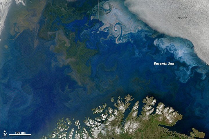
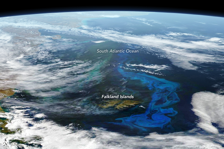
The other little things that PACE will examine have names like diatoms, coccolithophores, cyanobacteria, algae, and dinoflagellates. To borrow and mangle a quote from one of my favorite movie characters — Annie Savoy in Bull Durham — if you have three phytoplankton, they can’t do much. But if you have 300 billion of them, they can build a cathedral. Well, maybe not a cathedral, but they can develop into vast blooms that have a profound impact on life on this ocean planet.
Phytoplankton grow constantly on Earth and just about anywhere there are open, sunlit patches of water. When conditions are right, the growth of these microscopic cells can blossom to scales that are visible from orbit for days to weeks.
Phytoplankton are to the ocean what grasses and ground cover are to land: primary producers, a basic food source for other life, and the main carbon recycler for the marine environment. They are floating, plant-like organisms that soak up sunshine, sponge up nutrients, and create their own food (energy).
Why do we need to study these tiny organisms with PACE? While humans don’t really consume phytoplankton for food, the little floaters are fuel for the zooplankton, fish, and shellfish that we do eat. We also need to care about phytoplankton because they can influence water quality and human health. Some species of phytoplankton produce toxins that are dangerous to humans and animals; others can grow in such abundance that they crowd out other species or deplete the water of necessary oxygen.
Speaking of oxygen, phytoplankton produce a lot of it. Somewhere between 20 and 50 percent of the oxygen on Earth — some in our air, a lot in the ocean — is made by phytoplankton as they use photosynthesis to turn sunlight, carbon dioxide, and nutrients into sugars. In the process, they also draw carbon dioxide out of the atmosphere and, in time, sink it to the bottom of the ocean.
Better understanding the phytoplankton in the ocean will help us better understand the fisheries that feed us and our economy, and it can ultimately help us work toward cleaner waterways.
NASA and its research partners have been studying phytoplankton from space for decades, but mostly with just a few wavelengths of light. I am looking forward to the colors, textures, and details we will see with PACE’s OCI hyperspectral imager. As the PACE science team likes to say: we have been coloring the ocean with a box of 8 crayons, and now we are about to get a box with 128 shades of color. The leap in detail will allow scientists to better spot where phytoplankton are, but also figure out who (what species) they are.
And when PACE data are combined with observations from our recently launched SWOT mission — which studies the shape and movement of the surface of the ocean — it will be like going from the Earth-observing equivalent of the Hubble Space Telescope to the new James Webb Space Telescope.
Learn more about phytoplankton with these resources:
PACE Phytoplankton Exploration
The Insanely Important World of Phytoplankton
NASA Wants to Identify Phytoplankton Species from Space: Here’s Why.
As the Seasons Change, Will the Plankton?
Phytoplankton May Be Abundant Under Antarctic Sea Ice
Learn more about aerosols with these resources:
Just Another Day on Aerosol Earth
New NASA Satellite to Unravel Mysteries About Clouds, Aerosols
Global Transport of Smoke from Australian Bushfires
