The rural Karamoja region in northeastern Uganda is facing a severe drought that directly affects the population’s food supplies and livelihoods. Communities in this area rely on small-scale subsistence farming, and productivity is closely coupled with rainfall. In the arid Karamoja region, precipitation is highly variable in terms of where, when, and how much rain falls. The current dry spell has been ongoing since early 2022, contributing to the fourth consecutive poor harvest in the region.
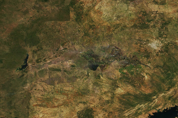
This map shows anomalies in Normalized Difference Vegetation Index (NDVI), a satellite-derived product used to assess crop conditions, for the Karamoja region. NDVI measures the health, or “greenness,” of vegetation based on how much red and near-infrared light the leaves reflect. The map displays the difference between NDVI in August 2023 and the average NDVI for August from 1991 to 2010. The data were collected by the Landsat 5, 7, 8, and 9 satellites.
Farmers in Karamoja typically cultivate small plots of 2 acres (1 hectare) or less and raise crops such as sorghum, maize, beans, and vegetables primarily for their own consumption, said Catherine Nakalembe, a geographical scientist at the University of Maryland and the NASA Harvest Africa Lead. Even in years of normal rainfall, she said, yields tend to be low because of poor soil quality and the lack of irrigation and fertilizers. “Many households cannot produce enough food to be self-sufficient, and they rely on food aid.” On top of these challenges, drought often causes crop failures.
Work by Nakalembe, who also serves as the Agriculture and Food Security Thematic Lead for the NASA SERVIR Applied Sciences Team, indicated that NDVI values for the month of August are a good reflection of what conditions were like throughout the growing season. “The vegetation health in August integrates the effects of rainfall deficits over the critical crop growth stages,” she said.
The 2023 rainy season in Karamoja was “erratic, largely below average, and interspersed with lengthy dry spells between April and August,” noted the Famine Early Warning Systems Network, or FEWS NET. Rainfall deficits were especially pronounced from June through August in the eastern part of the region.
Driven by the below-average harvest, loss of livestock, and weakened coping capacity among the population, crisis-level outcomes (Phase 3 in the Integrated Food Security Phase Classification system) are expected to persist in Karamoja through January 2024. This phase is characterized by above-usual levels of acute malnutrition or difficulty meeting minimum food needs.
The NASA Harvest program aims to expand the adoption of satellite Earth observations to benefit crop production and food security, among other agricultural applications. For example, its Global Agriculture Monitoring System (GLAM) allows specialists and non-specialists to visualize in near-real time the condition of croplands around the world. Another initiative, the GEOGLAM Crop Monitor for Early Warning project, is working to anticipate decreases in crop yields during the growing season by examining vegetation- and weather-related satellite data.
NASA Earth Observatory image by Wanmei Liang, using Landsat data from the U.S. Geological Survey. SRTM data from The 30-Meter SRTM Tile Downloader. Uganda boundary from The Humanitarian Data Exchange. International Boundaries from Department of State. Story by Lindsey Doermann.