

By Ludovic Brucker
The main objective of deep field traverses like ours is to make in-situ measurements and collect samples, which obviously cannot be done from air or space. So, during the 2010-11 and 2011-12 SEAT field seasons, we have been taking in-situ snow and radar measurements.
We typically had two different types of days during our traverse (both equally enjoyable!): traveling days, where we would move to a new site and set up camp, and days where we would collect snow measurements and drill a 20-meter deep snow core near our camp.
(Actually, we had a third type of day where we’d spend hours and hours shoveling during snow storms… but that’s a different story!)

My duties during the days we worked around our camp included digging a 2-meter deep snowpit and recording various measurements. When traveling on snowmobiles, or even while standing on the surface of the ice, one has no idea of what the snow lying beneath looks like. Amazingly, I often got a clear idea of the snow layering when burying anchors for setting up our tents. This provided a first quick overview of what it would look like the pit on the following morning.
Typically, my days started at 5:30 AM, when I would shovel snow in a cooking pot to get warm water for the rest of the crew, who were supposed to get ready in the following hour. The next step was to find the best place to dig the snowpit. Usually, a good place consisted of a uniform zone ranging several square meters and representative of the surrounding area. It also had to be free of sastrugi (small snow ridges created by the wind). Additionally, I had to take into account the sun’s position and how it was going to move across the sky in the following hours: it takes some time to dig the pit and collect measurements, and we absolutely didn’t want that the sun ended up warming the snowpit face where we’d be recording our measurements. Once I had decided on the location (usually a matter of seconds), I’d start digging.
After a good first hour of shoveling, I would have breakfast. Then I’d come back to excavate down to about 2 meters. The deeper the snow, the harder the layers got. I would usually shovel 6-7 cubic meters (211-247 cubic feet) of snow. The snow weighted about 300-400 kg (770-880 pounds) per cubic meter. I’ll let you do the math, so you understand that my colleagues’ help was always warmly welcomed!

Once the pit was dug, I would try to smooth the snow surface as much as possible, covering an area wide enough to simultaneously record the following measurements:
1) Infrared photography
We put an infrared filter in front of the sensor of a standard reflex camera to record the snow cover stratigraphy (that is, the stacks of snow layers). This modification allowed us to take pictures at infrared wavelength (700-1100 nm), which is more sensitive to snow properties (such as grain size) than visible light is.
So, by simply taking a couple of photos, we were able to identify the various snow layers. We also used reference panels to calibrate our photographs and to get an idea of the vertical snow grain size variation with depth.


2) Visual stratigraphy
After taking infrared pictures, I would visually identify the snow layering simply by looking at the snow wall. Each time I saw a change in grain size, snow structure, and so on, I would mark a new layer. This process is less accurate than using infrared pictures, because it can be visually challenging to identify smooth vertical variations from one layer to another. However, I’d normally be able to distinguish the main features. I would then take snow grain size and hardness measurements for each visually identified layer.

3) Snow temperature
We measured snow temperature at every 10-cm interval, from the surface to the bottom of the pit. Most of the time, surface temperatures were about -10oC (14oF), and the lowest temperatures (found 2 meters below the surface) ranged between -25 and -29oC (-13 and 20oF).
4) Thermal conductivity
Thermal conductivity values tell us about how efficiently heat propagates through the snow cover. This way we can understand how quickly air temperature variations can travel down the snow. Estimating heat transfer through the snow cover is important in modeling the energy exchange between the snow and the atmosphere, among other characteristics.
We made our measurements using three needle probes: the one in the center continuously measures snow temperature, while the two on the sides slightly warm the snow surrounding them. The idea is to measure how fast and with which intensity the heat wave reaches the temperature-recording needle.
5) Snow density
Another important characteristic of snow is its density, or mass for a given volume. We made those measurements at two vertical resolutions (2 and 10 cm) using density cutters (thin metalic shapes that I inserted in the snow wall to extract samples). I did know that hard snow layers exist in Antarctica, but I was surprised to find out how difficult it was to insert a thin sharp metal piece into these layers! We bagged and preserved the 2-cm-thick samples (they will be shipped to the BYU lab in Utah for further analysis) and we weighted the 10-cm-thick samples directly in the pit.
Our route went across the West Antarctic Ice Divide, a topographic feature formed by a large-scale weather system (an atmospheric depression that comes from the ocean and creates snow storms inland).
We traveled across this divide, which presents very different snow accumulation scenarios on each of its sides. On Byrd’s side, where we started and ended the traverse, snow accumulation is low. But on the other side of the divide, there’s more snow accumulating each year.
Each camp we worked at presented different snowpacks, though they shared specific distinguishable layers at given depths. For instance, there was a layer with large snow grains at 0.92 m depth – this layer was visible throughout hundreds of kilometers.
In summary, during the 2011 SEAT traverse, we dug seven snowpits and collected all the above measurements down to 2 m deep. Now, it’s time to get in front of the computer to analyze and understand these incredible data sets!
By Lora Koenig
Byrd Station (Antarctica), 12 December —The traverse team left yesterday and made it to Camp 1, 95 kilometers (59 miles) away. I spoke with Michelle last night; they had a few problems yesterday. One was that some bolts on the bottom of the radar sled came loose and the sled started to detach from one of the snowboards that serves as the sled runner. Ludo saw this early in the traverse (3 km, or 1.8 mi, out) and he and Clem fixed the sled with the spare parts kit. They used up all of the spare bolts to fix it. Last night, Michelle and Randy relayed the specifics of the bolts to me and I asked the Byrd mechanic, Paul, if he had any bolts to spare. He did. I added the bolts to the cache list.
The radar team had one additional problem. At some point, with all of the bumping of the sled, the GPS became unplugged. Without the GPS running we cannot tell where the radar data was taken. Ludo and Clem figured out that they had lost about 25 km (15.5 mi) of data. So they turned around, went back and recollected the data. They drove over 140 km (87 mi) yesterday! A huge day. Spirits were high and all was well at SEAT Camp 1 last night.
This morning I woke up at Byrd to patches of blue skies. The pilots told me that we would put in the caches if the weather was good enough for flying, so I jumped out of my sleeping bag ready to go. Also, if the weather held, I would catch a late night flight out of Byrd to McMurdo. I quickly packed my sleep kit and duffle so I would be ready to leave if a plane came. I went to the communications tent to talk with the pilots. At 7 AM they were already loading our 55-gallon drums of fuel in the DC-3 Bassler plane, so I knew we were going to try and put in the caches.

I made a quick stop in the galley on the way to the plane to see if they had any treats I could add to the caches. They gave me a loaf of bread and some home-baked chocolate chip cookies that I tucked into my backpack along with some Snickers bars, teas and letters for the team.

The Bassler took off just before 8 AM. At 8:15 we flew over the traverse team at SEAT Camp 1. I was up in the cockpit so I could see better. Everyone —Michelle, Jessica, Randy, Clem and Ludo— came out of the tents to wave at the plane and the copilot, who was flying the plane at the time, dipped a wing to wave hello. About 15 minutes later, the pilots started looking for a site to land and drop the first cache. The original GPS location did not have good surface definition so we landed about2 km (1.2 mi) away from the planned camp site. I left the bolts, bread, a note and an ice core box for the team.


We continued to take off and land at each of the five cache sites. We were able to land exactly at the location of three of the five cache site and at two of the sites the team will have to snowmobile out to retrieve the caches. The caching went fast and took just over 2 hours. At each site, the team will get more premix and mogas, ice core boxes, and a surprise: At the first site, bread; at the second, cookies; at the third, crackers and stickers; at the forth Snickers bars and a Christmas card; and at the fifth, hot chocolate and tea. I told Michelle that I had left a letter at each site but they have no idea that they have gifts too. I hope they enjoy their surprises.
Along the route, I watched the surface carefully. I was looking for sastrugi (wind-blown snow dunes) that could slow the team’s progress, as well as for crevasses. We had already looked at the satellite imagery for crevasses, but it is always good to look with your own eyes. The surface conditions over the route were very smooth (though that could change with a big storm), and there were no crevasses.


When we returned to Byrd, I needed to relay the cache positions to the team. I called Mac Ops (McMurdo Operations), where the team checks in everyday. Michelle knew to check-in in the evening to get the cache coordinates. I gave Mac Ops the cache locations and left a message for Michelle to call Byrd Camp for more information on the route conditions. Since I was expecting to get a flight out that afternoon I left detailed notes with the Byrd Camp manager, Kaija.
In the early afternoon, a fog bank came in over Byrd Camp and I knew I would not be leaving today. I spent the afternoon digging out fuel bladder to help contribute to camp choirs. There is always a lot of work to be done at field camps. At 9 PM I answered the call from Michelle to Byrd Camp. She was surprised to hear my voice. I told her about the route and she told me they had completed drilling the ice core at Camp 1. They plan on traveling to Camp 2 tomorrow. Great progress! The team is happy and excited to be making such good time. We are all happy that the caches are in so they can complete their work without worrying about getting good enough weather for a plane to fly.

I am now just waiting for a plane to arrive so I can get home. I am over a week delayed getting back. The good thing is that the traverse team has made up time at both Byrd and Camp 1 and are almost back on schedule after the delays in McMurdo.
Other news from Byrd Camp is that the camp population was very small last night. After the Bassler cached our supplies it took off to fly for Polenet, another science team at Byrd putting out seismometers and GPS stations. The Bassler could not return to Byrd due to fog that rolled in, and it had to divert to WAIS Divide camp, so about eight people are staying there for the night.
Here’s hoping for better weather tomorrow though the forecast does not look good.
By Lora Koenig
Byrd Station (Antarctica), 8 December — Today was our first day in the deep field at Byrd Camp. Byrd Camp sits in the middle of the West Antarctic Ice Sheet at an elevation of about 5,700 ft (1,737 m). We are standing on over 2,000 m of ice, with the oldest ice being about 50,000 years old. (The ice nearby at WAIS divide camp is a bit older and deeper. To find out more about the deep ice underneath us check out this information on the WAIS Divide ice core, which is being drilled deep into the ice nearby.) When you look out from camp you see nothing but the flat white snow and an old drill tower sticking out of the ground.
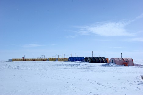
We are, specifically speaking, at Byrd Surface Camp. The original Byrd Camp, established in the 1956-1957 season, is underneath us, except for a drill tower that still sticks out above the snow. Over the years, snow accumulation (which averages around 12 cm per year at Byrd) buried the original camp and created Byrd Surface Camp, which everyone just calls Byrd. It is exactly this snow accumulation that we are here to measure with ice cores and radars. Here is an article about the history of Byrd.
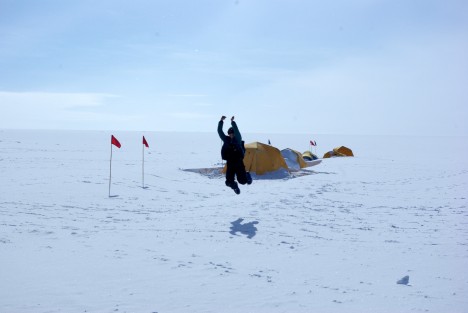
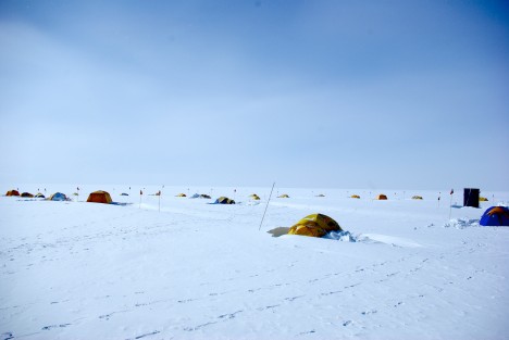
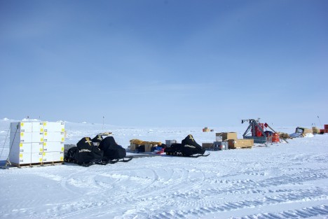
The team was prepared to work hard today because we know the more time we make up from the weather delays, the quicker the traverse team can get home. The day started with all of us breaking down the pallets of gear. Once all the gear was off of the pallets, we divided and conquered the tasks for the day. Michelle started loading and organizing the sleds. Randy fueled all the snowmobiles and Jerry cans. We brought nine 55-gallon drums of premix gas for the snowmobiles for the entire traverse. Jessica prepared all of the drilling gear for the first core, which we’ll drill tomorrow. Clem, Ludo and I built the radar sled, attached the antennas and hooked up all of the radars for testing. Clem also set up a GPS base station that we will use to correct our roving GPS on the radar so we know precisely where the radar data is located throughout the traverse.
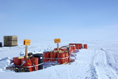
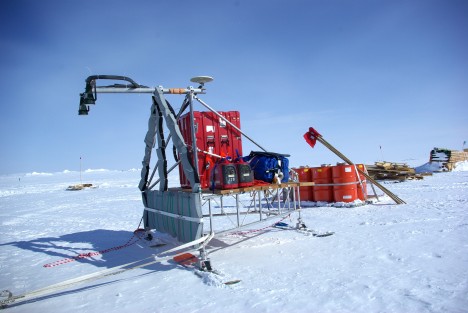
We discovered a few problems today. First, Jessica realized that the power converter for the drill battery did not make it to the field. The drill is made in Switzerland and has a different power plug. While this was an unfortunate oversight, it will not affect the science: We can charge the drill battery with the solar panels. The sun is up 24 hours a day here, so that will provide more than enough charge for the battery. Also, we carry an electronics tool kit, so in case of need we can cut the wires and make a new plug.— we call it “MacGyvering” (i.e., improvising fixes to our materials in the field).
The second problem of the day is a bit more worrisome. The Ku-band radar data has a systematic noise level that we cannot troubleshoot. We know that it has something to do with the computer that runs the radars, but we cannot determine whether or not the problem is coming from radio frequency emission from the computer itself getting into the antennas or if it is a data writing problem with the computer software. It has been a long day, so the trouble-shooting will have to be left for tomorrow. We hope that nothing was broken on the computer during the combat off-loading. We will know more tomorrow.
The sleds are ready to drill our first core tomorrow!
By Lora Koenig
Byrd Camp (Antarctica), December 7 — At 4:45 PM today we boarded another Delta for a ride to Pegasus field. The last weather report we had for Byrd Camp was for half-mile visibility and 40-knot winds with blowing snow. The conditions were predicted to continue to deteriorate, so I expected the flight to be canceled. When we arrived Pegasus we saw our gear being loaded on an LC-130 flown by the 109th Air Wing. We also saw a plane taxiing to the skiway that was headed to WAIS Divide camp, which is about 100 kilometers (62 miles) from Byrd. So when we say that plane take off, we knew we had a good chance of getting into Byrd.


We took off at around 8 PM for the 3-hour flight to Byrd. Jessica got to ride in the cockpit for take-off. During the flight, we looked out the windows into clouds for most of the time, but at one point the Ross Ice Shelf was visible and we saw a large crack in the ice shelf, which was exciting to see though I do not know anything about the science behind it. I will ask and expert in a few weeks and get back to you with more information about the crack.


We arrived Byrd Camp around 11:00 PM. After we landed, all of our cargo was combat off-loaded. A combat off-load is when they open the back of the LC-130 and send the palettes out the back with a swift kick and a sudden acceleration of the plane. This method is very rough on our gear and we will have to double-check everything again to make sure nothing is broken. One of my constant reminders to the team is, “Don’t break anything”: We have to fix anything we break and we may not have the parts. So combat off-loading of gear makes me very nervous, but we didn’t have any other choice. And it is actually really fun to see the combat off-loads if you forget that it is your gear.
Here are some pictures of the combat off-load:


Here is a picture of the team finally in the field.


We had a quick tour of Byrd Camp and then went to tent city to our tents to sleep for the night. I was warm all night but others were a bit cold on their first night in their tents. We are finally ready to start the science!


