By Lora Koenig
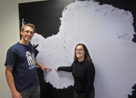
I am feeling a little sad as I write this post. I always do when writing the last post of a research season. Being able to share my science is one of my favorite parts of my job. I assume some of you looked at our blog’s photos and thought “they’re crazy,” while others started planning how they too could get to Antarctica. Either way, I hope you have found this blog interesting, entertaining and inspiring and that you learned a bit about how we measure snow accumulation in Antarctica.
For some quick updates: Jessica, Randy, and Clem are back home in Utah, Michelle is on her way back to Copenhagen, and Ludo and I are back at Goddard Space Flight Center in Maryland. Our radar gear has already arrived from Antarctica and has been packed away in the lab to wait for another season. Our ice cores made their way from WAIS Divide Camp to McMurdo a few weeks ago but it is uncertain if they will make it back to the U.S. this year: There has been a problem with the ship going to McMurdo, which just passed an inspection in New Zealand and is now making its way to Antarctica. We are hopeful that the cores will make it on the ship northbound but have been told not to expect it. Just another example of the logistical difficulties of working in Antarctica! If the cores do not return this year, it will not affect the science, just our patience. The cores will stay in a freezer until the next ship comes in February 2013. But we’re keeping our fingers crossed that our cores are loaded on this year’s ship.
My next field season, and therefore field blog, is not set right now but please continue to follow online the work that my colleagues and I do at our lab’s website, on Twitter, and through the NASA Visualization Explorer app for the iPad. Results from this research will be posted through those outlets.
Also, the complete collection of our expedition’s blog posts is here.
Until next time, stay warm!
By Randy Skinner
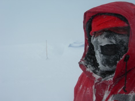
The wind began to blow at approximately 1:00AM on December 20. In Antarctica the wind blows most of the time, as there is nothing to slow it down and air is continually shifting from location to location due to density. But this was different: The force of the wind was strong enough to cause our tents to shudder continually, making it very hard to sleep. Snow began drifting around the tents, and packing between the tent body and fly. The force of the wind would even drive snow through the tent body, so that it showered down upon you.
At 6:30AM, Clem stopped by my tent to let me know that we would not be traversing to site 5 that day, as the weather was so bad. Following breakfast ,we began to build snow walls to protect the tents from the force of the wind. A flag line was put up to guide us from tent to tent in the event visibility dropped below 10 feet (3 meters). We checked the sled loads to make sure they were tied down well, and tightened all of the tent guy-out points. By noon the wind was blowing even stronger.

A small portable weather station that we had with us recorded wind speeds of 35mph (56 kph) with a wind chill temperature of -32 degrees Celsius (-25.6 degrees Fahrenheit). Noting to do but hunker down and read or sleep. The wind did not change all day long, except to increase and decrease slightly in speed. Every slight ebb of the wind strength would give us the hope that it was ending, only to have those hopes dashed at the next strong gust.

We awoke on the morning of Dec. 21 to more of the same. Drifts of snow around our tents were 3 to 4 feet high (0.9-1.2 meters). The wind had scalloped out snow in other places making walking around camp treacherous. Mac-Op’s assured us that we should start to see improvement later that day, so we were hopeful that we would not have to re-build our eroding snow walls. The rule of the day was to dig. Every time I, or anyone else was out of their tent, we dug the snow away from our own tent and then the others’. This was to keep the doors open, and the tent from being collapsed by the weight of the accumulating snow.

By 8:00PM the wind had dropped enough that we began digging 2 to 3 feet (0.6-0.9 meters) of snow away from the sleds, and unpacking the snow from the engine compartments of the snow machines. We worked for several hours to free all of the equipment so that it would be ready to traverse in the morning.

The storm on Dec. 20 was great practice for the storm that came on the evening of Dec. 23. Just as we finished dinner the wind picked up noticeably to around 30mph (48 kph). We had built a long continuous snow wall behind the tents as we sat up camp the day before. The wind had drifted snow all the way to the top of our 4-foot wall, and snow was now drifting between the tents. Ludo and Clem set to work to make the wall higher and dig the drifts down.
In the morning of Christmas Eve, the wind was stronger than at any time during the first storm. Clem commented that this was possibly the worst polar storm he had ever been in. This coming from a man on his second trip to Antarctica, as well as having spent time in Greenland did not comfort me very much. By evening time the wind was gusting in excess of 50mph (80 kph). Blowing snow limited visibility to less than 25 feet (less than 8 meters), and the wind chill was at -48 degrees C (-54 degrees F). Drifting snow had mostly buried Jessica’s tent, and we abandoned it and she moved into the Scott Tent for the night.

Christmas Eve was cancelled due to weather.
Christmas morning was more of the same. The snow was drifting so bad that the restroom myself and Ludo had built was no longer useable. Someone was getting out of their tent every 2-3 hours to dig out the other tents. Snow drifts around one tent became so bad the tent appeared to be in the bottom of a small snow-coliseum.
Fortunately for us, Mac-Op’s assured us that we were on the edge of the storm.
By the evening of Christmas Day the wind of the second storm had begun to slack in strength, and once again we began to dig ourselves out. Because of things we had learned from the first storm, the sleds and snowmobiles were not as packed with snow, even though the storm was stronger. The tents however were nearly buried, and removing some of the dead-men anchors was very time consuming.

Fortunately we did not have the opportunity to use again what we had learned about pitching the tents during the second storm, as this was our last bit of bad weather.
By Ludovic Brucker
The only wildlife we saw during our three-week traverse was three snow petrels and one Antarctic petrel. I still haven’t decided if they were sort of a Christmas gift, or the announcement of a storm!
The birds visited us when we were at camp 5,430 km (265 mi) inland. I was surprised to see them so far away from the coast and once I was back at McMurdo, I looked for a bird specialist on base and found Dr. David Ainley, who gave me some info about the birds that I want to share with you.
Snow petrels are all white except for their black eyes, eyelashes and feet/legs.


The Antarctic petrel is mostly black though white below and with white trailing edges to wings, it has pink legs and black feet. Unfortunately, we didn’t have the time to take pictures of this bird, so we simply enjoyed watching it.
These two species are seabirds. They never leave the Antarctic (that is, they never fly north of the Antarctic Polar Front) and spend most of their lives at sea, mainly associated with sea ice. Adults spend about four months of the year nesting. They build their nest in cavities in the slopes of inland nunataks (exposed rocks in ice fields or glaciers) and mountaintops. Most of these birds’ breeding areas are still unknown to the scientists studying them, though they are known to nest in the Fosdick and Ford ranges in Marie Byrd Land.
About six million Antarctic petrels (30 percent of its total population, according to at-sea surveys) and one million snow petrels (their total population is unknown) feed during summer in the Ross Sea: that is why there’s a push to designate the Ross Sea a marine protected area. Furthermore, according to Dr. Ainley, the Ross Sea also hosts 38 percent of the world’s adelie penguins, and 26 percent of its emperor penguins. You can read about the efforts to preserve the Ross Sea here.
Our traverse was on Mary Byrd land, where, as I mentioned above, many petrels breed. So the birds we were lucky to see weren’t lost, as I had initially thought, but flying from or returning to their nests.
By Ludovic Brucker
Once the traverse was over and we had drilled nine snow cores (with a combined length of 156 meters, or 512 ft), the next step was flying to each of our drilling sites and bringing the cores to the West Antarctic Ice Sheet (WAIS) station to store them before they are shipped (hopefully soon!) to McMurdo and then to Bringham Young University for our analyses.
Three days before we completed our traverse, Michelle initiated talks with the flight schedule team to coordinate pickup dates for the ice cores. Usually, there are three planes operating from Byrd Station: two Twin Otters and a Basler. However, during the weeks following our traverse, there was only one Twin Otter available and it had to be shared with other scientific missions. In the end, the flight schedule team decided to assign us a flight on December 30th .
However, on the 28th, the morning following our arrival to Byrd, the Twin Otter pilots’ weather check at 7 AM revealed that it was impossible to fly another scientific mission planned for that day due to possible fog. They decided they would check the weather forecast again at 10 AM and probably fly our mission instead.
Meanwhile, Randy and Jess were reading in their tents, Clem was somewhere, looking for his brand clean pair of socks, Michelle and I were shoveling snow… yes, it seemed like we weren’t able to stop shoveling even after the traverse was over. Suddenly, Tony, the Byrd Camp supervisor, informed us that the pilots were going to perform our mission in the following half hour! This was excellent news.
The half hour gave us some time to drive 3 kilometers (1.86 miles) out of Byrd to dig out the first 18 core segments (each one of them about one meter, or 3.3 feet, in length) we had drilled three weeks before. Randy and I jumped on a snowmobile and headed there, while Michelle and Clement attached a sled to their snowmobiles to bring the cores to the plane, and joined us a few minutes later. We had to drive very slowly to make sure the cores didn’t get damaged during the ride.

As I mentioned, the plane that was going to help us was a Twin Otter, which is smaller than the Basler that flew our cache with Lora the day after we started the traverse. Due to its smaller size, we would not be able to collect the 18 boxes and five fuel drums at the same time. We would have to fly first to three sites, fly back to WAIS station to deliver the cores (just on time for lunch!) and then fly to the three remaining sites, heading back to WAIS at around 4 PM.

Using our site GPS location coordinates, it was extremely easy to find the orange fuel drums that marked the sites, and then locate the buried snow core boxes.

At each site, the pilot flew over the place one to four times before landing, to determine the best landing spot. That gave us a chance to enjoy our itinerary and former camps from above!

Once on the ground, the plane taxied until it got right next to our cargo, which made it super easy to carry the core boxes and drums inside. Once the plane stopped, it was our turn to work. And by work I mean shoveling snow! By then, I was beginning to consider shoveling to be more of a hobby than work. We had to carefully dig out the snow core boxes and bring them and the fuel drum inside the plane as quick as possible. It was a great day, and I believe we were pretty efficient; it never took us more than 20 minutes between landing and take off.

Because we were in an open field, the pilots had to taxi back and forth on its own tracks a couple of times, to compact and smooth the surface before taking off. Once the pilot and co-pilot were satisfied with the consistency of the snow beneath, they would push the accelerator.

Between each site, we flew at low elevation (100 m). It was incredible to see some of our traverse legs from above, and even though we had encountered some pretty breezy days during the previous weeks, it was still possible to see our snowmobile tracks in some places.
After visiting three sites, it was time to fly back to WAIS Station. The plane was full, and heavy! This last take off seemed longer (much longer) than the previous ones… and definitively bumpier too.
After about 20 minutes in the air, we saw WAIS Station appear on the horizon.

It was a strange feeling, to see a man-made structure appear in the middle of nowhere. It reminded me of the way I felt while, during the traverse, we were looking for our cache, and suddenly there it was, sitting in a great white vastness.
Five WAIS staff people were already on the ice waiting for us, or, more probably, they were waiting for the core boxes to bring them quickly into the freezer.

After a good lunch at WAIS, we continued our ice core picking. By 4 PM, all cores were stored in the WAIS freezer. After then, the 2011 SEAT field work was truly completed. We had stayed safe, we hadn’t broken anything (or at least nothing vital than couldn’t be fixed), and we had had a fantastic life experience that will also help us better understand snow accumulation over West Antarctica!
Fair warning: Keep in mind that the ice cores still had a long way to go before reaching their final destination, the freezers at Bringham Young University!
By Ludovic Brucker
The main objective of deep field traverses like ours is to make in-situ measurements and collect samples, which obviously cannot be done from air or space. So, during the 2010-11 and 2011-12 SEAT field seasons, we have been taking in-situ snow and radar measurements.
We typically had two different types of days during our traverse (both equally enjoyable!): traveling days, where we would move to a new site and set up camp, and days where we would collect snow measurements and drill a 20-meter deep snow core near our camp.
(Actually, we had a third type of day where we’d spend hours and hours shoveling during snow storms… but that’s a different story!)

My duties during the days we worked around our camp included digging a 2-meter deep snowpit and recording various measurements. When traveling on snowmobiles, or even while standing on the surface of the ice, one has no idea of what the snow lying beneath looks like. Amazingly, I often got a clear idea of the snow layering when burying anchors for setting up our tents. This provided a first quick overview of what it would look like the pit on the following morning.
Typically, my days started at 5:30 AM, when I would shovel snow in a cooking pot to get warm water for the rest of the crew, who were supposed to get ready in the following hour. The next step was to find the best place to dig the snowpit. Usually, a good place consisted of a uniform zone ranging several square meters and representative of the surrounding area. It also had to be free of sastrugi (small snow ridges created by the wind). Additionally, I had to take into account the sun’s position and how it was going to move across the sky in the following hours: it takes some time to dig the pit and collect measurements, and we absolutely didn’t want that the sun ended up warming the snowpit face where we’d be recording our measurements. Once I had decided on the location (usually a matter of seconds), I’d start digging.
After a good first hour of shoveling, I would have breakfast. Then I’d come back to excavate down to about 2 meters. The deeper the snow, the harder the layers got. I would usually shovel 6-7 cubic meters (211-247 cubic feet) of snow. The snow weighted about 300-400 kg (770-880 pounds) per cubic meter. I’ll let you do the math, so you understand that my colleagues’ help was always warmly welcomed!

Once the pit was dug, I would try to smooth the snow surface as much as possible, covering an area wide enough to simultaneously record the following measurements:
1) Infrared photography
We put an infrared filter in front of the sensor of a standard reflex camera to record the snow cover stratigraphy (that is, the stacks of snow layers). This modification allowed us to take pictures at infrared wavelength (700-1100 nm), which is more sensitive to snow properties (such as grain size) than visible light is.
So, by simply taking a couple of photos, we were able to identify the various snow layers. We also used reference panels to calibrate our photographs and to get an idea of the vertical snow grain size variation with depth.


2) Visual stratigraphy
After taking infrared pictures, I would visually identify the snow layering simply by looking at the snow wall. Each time I saw a change in grain size, snow structure, and so on, I would mark a new layer. This process is less accurate than using infrared pictures, because it can be visually challenging to identify smooth vertical variations from one layer to another. However, I’d normally be able to distinguish the main features. I would then take snow grain size and hardness measurements for each visually identified layer.

3) Snow temperature
We measured snow temperature at every 10-cm interval, from the surface to the bottom of the pit. Most of the time, surface temperatures were about -10oC (14oF), and the lowest temperatures (found 2 meters below the surface) ranged between -25 and -29oC (-13 and 20oF).
4) Thermal conductivity
Thermal conductivity values tell us about how efficiently heat propagates through the snow cover. This way we can understand how quickly air temperature variations can travel down the snow. Estimating heat transfer through the snow cover is important in modeling the energy exchange between the snow and the atmosphere, among other characteristics.
We made our measurements using three needle probes: the one in the center continuously measures snow temperature, while the two on the sides slightly warm the snow surrounding them. The idea is to measure how fast and with which intensity the heat wave reaches the temperature-recording needle.
5) Snow density
Another important characteristic of snow is its density, or mass for a given volume. We made those measurements at two vertical resolutions (2 and 10 cm) using density cutters (thin metalic shapes that I inserted in the snow wall to extract samples). I did know that hard snow layers exist in Antarctica, but I was surprised to find out how difficult it was to insert a thin sharp metal piece into these layers! We bagged and preserved the 2-cm-thick samples (they will be shipped to the BYU lab in Utah for further analysis) and we weighted the 10-cm-thick samples directly in the pit.

Our route went across the West Antarctic Ice Divide, a topographic feature formed by a large-scale weather system (an atmospheric depression that comes from the ocean and creates snow storms inland).
We traveled across this divide, which presents very different snow accumulation scenarios on each of its sides. On Byrd’s side, where we started and ended the traverse, snow accumulation is low. But on the other side of the divide, there’s more snow accumulating each year.
Each camp we worked at presented different snowpacks, though they shared specific distinguishable layers at given depths. For instance, there was a layer with large snow grains at 0.92 m depth – this layer was visible throughout hundreds of kilometers.
In summary, during the 2011 SEAT traverse, we dug seven snowpits and collected all the above measurements down to 2 m deep. Now, it’s time to get in front of the computer to analyze and understand these incredible data sets!
alert message
