
Spring and summer flooding is not unusual in southern and central China, but the floods of 2007 were unusually widespread and destructive. Initial assessments in Guangdong, the southernmost province in mainland China, gauged the floods there to be the worst in 50 years, reported the International Federation of Red Cross and Red Crescent Societies. Weeks of heavy rain caused floods and landslides in six southern provinces in June. By June 15, said the Xinhua News Agency, 128 people had died and an additional 24 remained missing as a result of the floods. More than 22 million people and 1.22 million hectares (4,710 square miles) of crops had been affected, Xinhua added.
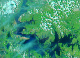
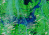
The Moderate Resolution Imaging Spectroradiometer (MODIS) on NASA’s Terra satellite captured the top image of floods around Dongting Hu (Hu means “Lake” in Chinese) in central China’s Hunan province on June 16, 2007. Though this was not the most severely impacted part of China, flooding was evident around the lake. The lake itself had grown in size since May 20, when Terra MODIS captured the lower image. The rivers that feed the lake were also swollen, the water inky black to dark blue in this false-color image. Both images were made with a combination of infrared and visible light to highlight the presence of water on the ground. In this type of image, clouds are light blue and white, plant-covered land is bright green, and bare earth is tan-pink. The city of Yueyang is the cement-gray area on the northeastern shore of Dongting Lake.
Daily images of southern China are available from the MODIS Rapid Response System in both false color, as shown here, and photo-like true color.
NASA images courtesy the MODIS Rapid Response Team at NASA GSFC.


