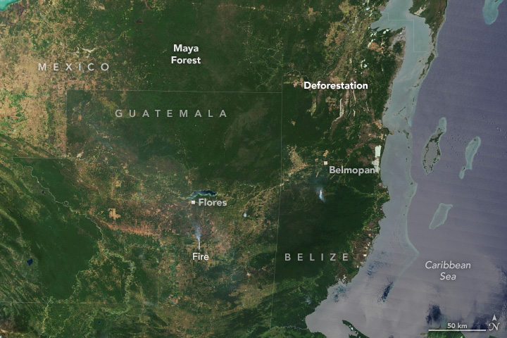
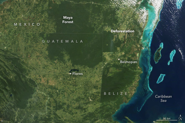
The Selva Maya, or Maya Forest, spans 150,000 square kilometers (60,000 square miles)—about the size of the U.S. state of Illinois—across parts of southeastern Mexico, northern Guatemala, and Belize. It is the largest tropical rainforest in Mesoamerica, second only to the Amazon in the Americas. Home to hundreds of thousands of people, countless archaeological sites, and thousands of plant and animal species, the forest is rich with human history and biodiversity.
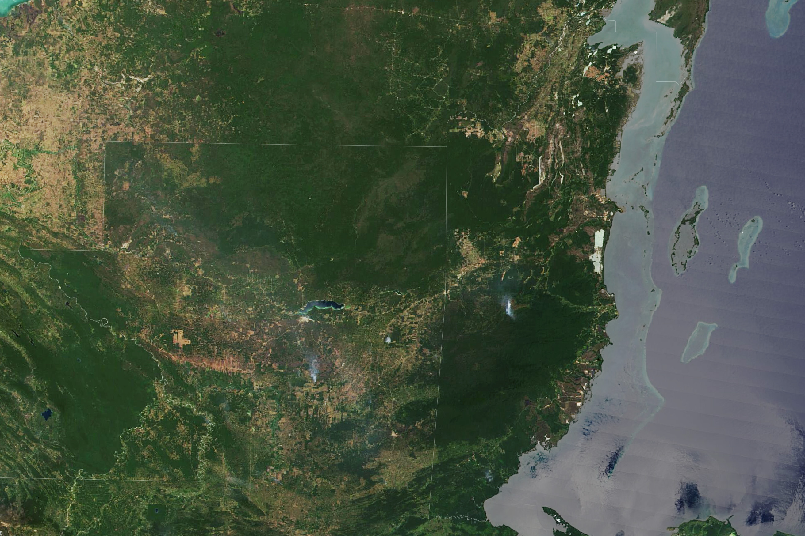
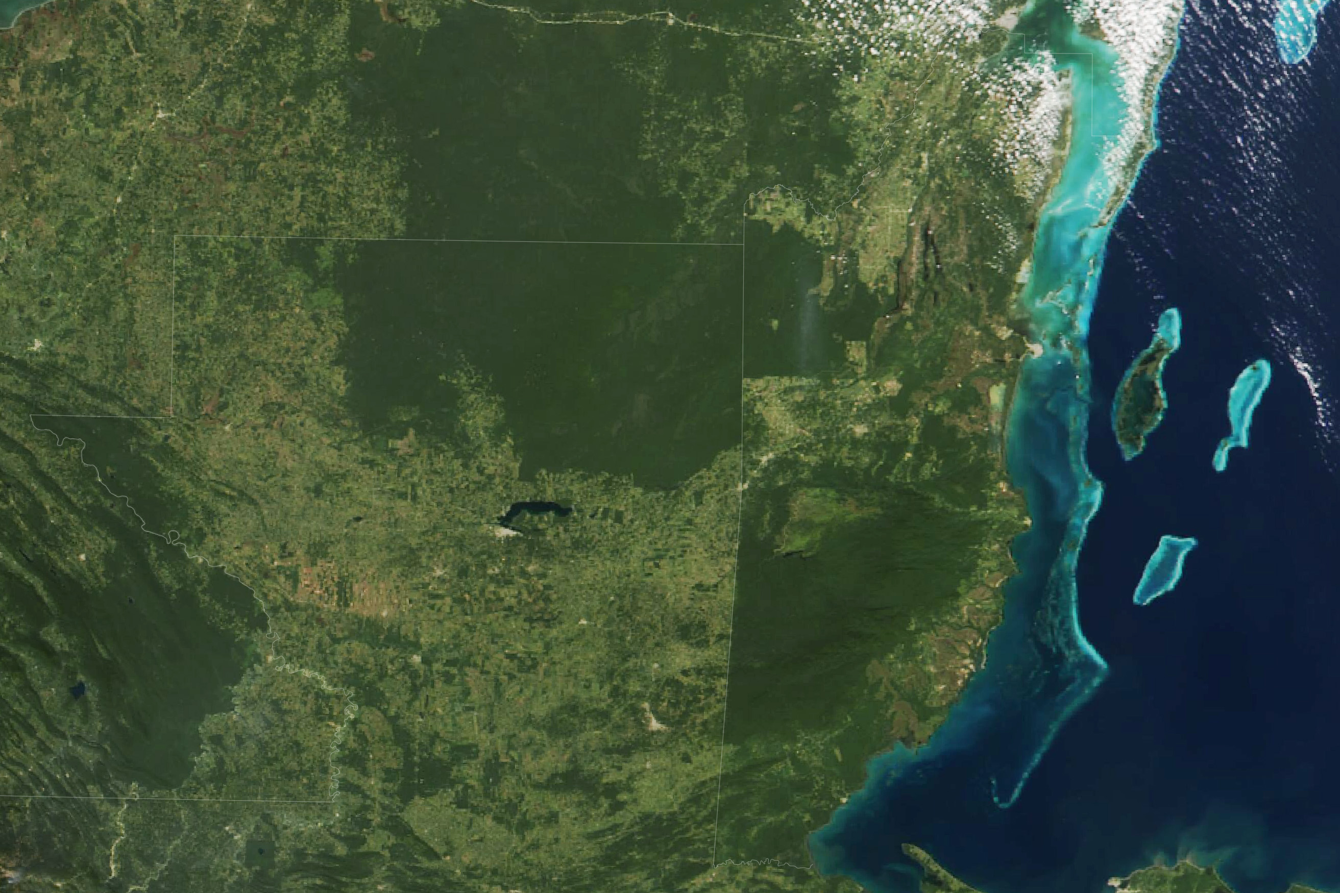
However, the Selva Maya is changing. Satellite data show that, like the Amazon, large sections of this forest have been cleared in recent decades. The extent of forest cover loss is visible in the pair of MODIS (Moderate Resolution Imaging Spectroradiometer) satellite images above. The first image (left) was captured in 2000; the second image (right) shows the same area in 2024.
Forest loss is particularly pronounced in Petén, a department in northern Guatemala, west of Belize. Data from the Landsat Program, processed by researchers at the University of Maryland, indicate that Guatemala lost 23 percent of its forest cover between 2001 and 2023, and Petén lost 33 percent.
“The spread of cattle ranching has been the major driver of deforestation in Guatemala in recent decades,” said Diego Incer, a remote sensing expert at the University of the Valley of Guatemala. “But the situation is dynamic. We often see forests that were initially cleared for ranching later become palm oil plantations.”
The expansion of oil palm, source of the world’s most consumed vegetable oil and an ingredient in many packaged products, has been particularly swift in Guatemala. One analysis of Landsat imagery found that the land devoted to oil palms in the region surged from roughly 30 square kilometers (12 square miles) in 2001 to 860 square kilometers (332 square miles) in 2017, with much of the new oil palm farms located in southeastern Petén.
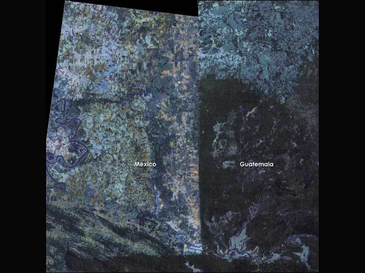
Forest losses are evident even in protected areas, such as the Maya Biosphere Reserve in northern Guatemala. Tom Sever and Dan Irwin, NASA researchers who worked in the region in the 1980s and 1990s, helped spur the establishment of the reserve by showing the country’s president a mosaiced image (below) from the Landsat 4 and 5 satellites that showed a stark contrast between the deforested landscape in Mexico and the lush, seemingly untouched forests of northern Guatemala in false color. The reserve covers one-fifth of Guatemala’s land area and contains four national parks, multiple wildlife refuges, and multi-use zones where the government granted forest concessions to several communities and companies to manage the forest.
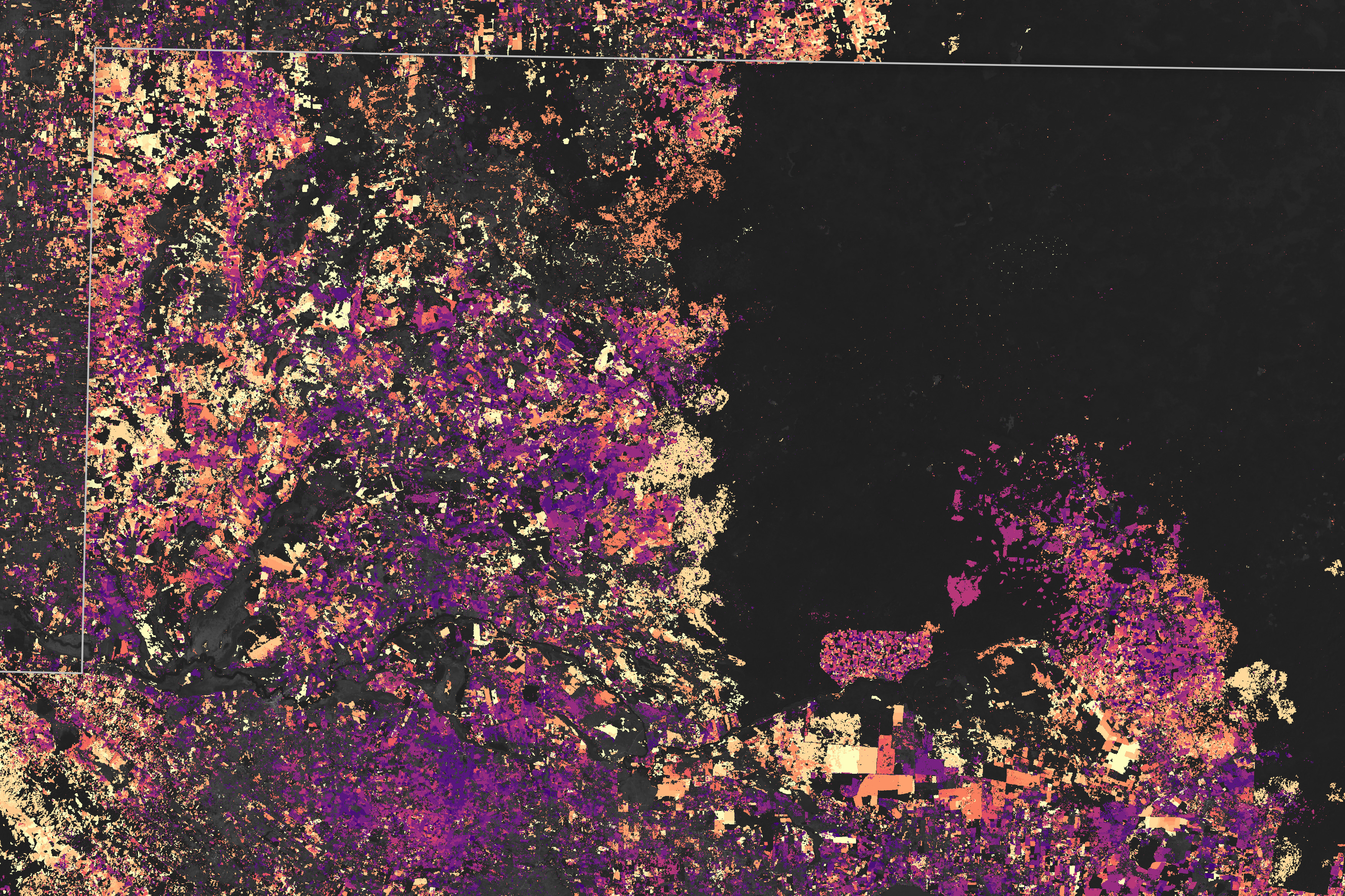
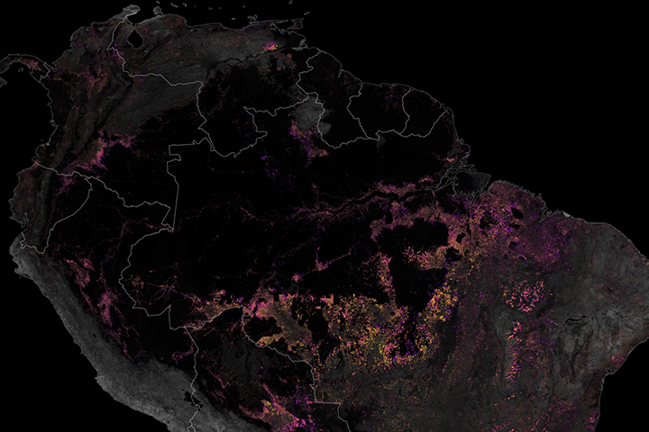
The map above, based on Landsat observations collected between 2000 and 2023, shows the progression of forest loss in part of the Maya Biosphere Reserve. Older losses appear purple, while more recent losses appear yellow. The map is based on forest cover loss data collected by Landsat satellites and processed by the Global Land Analysis and Discovery (GLAD) laboratory at the University of Maryland.
When the reserve was created in 1990, people living in the multi-use zones were permitted to stay on the land if they committed to using the forest in sustainable ways. Several of these concession areas saw a proliferation of low-impact ventures, such as the selective logging of mahogany and other timber and the harvesting of allspice, honey, xate palm fronds, and chicle resin. These ventures provided people with income and an incentive to keep the forest intact. Over time, the multi-use zones on the eastern side of the reserve have proven to be much more resistant to deforestation (black in the map above).
In contrast, the two national parks in the western part of the reserve—Laguna del Tigre and Sierra del Lacandon in northwestern Petén—have seen some of the fastest rates of forest loss in the reserve and in Latin America, despite having the strictest land use rules. Signs of forest disturbance began to appear in satellite imagery of Laguna del Tigre National Park in its earliest days, especially near roads built for exploratory gas and oil drilling projects. With roads in place, land speculators, timber and mining prospectors, and others soon followed.
According to Texas State University researcher Jennifer Devine, experts working with Landsat imagery and aerial photography have identified many cattle ranches in the region with unusual characteristics—isolated pastures, shortages of cattle, and the presence of clandestine airstrips—that suggest the ranches are being used for purposes other than cattle ranching. Her analysis suggests that much of the deforestation in Laguna del Tigre National Park since 2000 is a byproduct of illegal activity.
Despite such challenges, there are signs that Guatemala’s forests could have a brighter future. “The rate of forest loss has decreased over the past decade, and the total forested area has stabilized in recent years,” said Danger Gómez, the head of Geographic Information Systems at Guatemala’s National Forest Institute (INAB).
The improvement is largely due to successful community forestry projects in several concession areas. Also, starting in 2009, Guatemalan conservation authorities began to wrest back control of certain forest concessions along the road to Carmelita that had been hotspots of deforestation due to encroachment by ranching interests. As of 2024, they had expelled ranching operations from at least 137,000 hectares (339,000 acres) within the reserve and had started to replant forests in some areas, according to Eos.
NASA satellite data played a role in the successes of the community forest projects that prevented forest losses. For more than a decade, Guatemala’s conservation agencies distributed daily fire hotspot maps via email and messaging apps to stakeholders in Guatemala’s multi-use zones. The data, based on observations from NASA’s Terra and Aqua satellites, made it possible to quickly locate new fires and help communities reduce forest loss. The system, called Geospatial Information System for Fire Management (SIGMA-I), was developed by Guatemala’s Council for Protected Areas (CONAP) with technical and financial support from SERVIR, a joint NASA and USAID initiative to support locally led efforts to combat environmental problems.
Several communities in the area, including some that are part of the Association of Forest Communities of Petén (ACOFOP), have proven that it is possible to keep local deforestation rates at nearly zero. Some have already been rewarded with 25-year extensions to their concessions.
“It is inspiring to see what can be achieved in terms of forest resource management when local organizations are empowered with technology,” said Africa Flores, a research scientist at NASA’s Marshall Space Flight Center who contributed to the SIGMA-I project. “Kudos to our Guatemalan colleagues for effectively using technology to improve their natural tropical forest resources.”
Gómez added: “Now our challenge is to replicate successes like that across the entire reserve and country.”
Editor’s Note: Read an accompanying story about forest cover loss in Belize.
NASA Earth Observatory images by Wanmei Liang, using VIIRS data from NASA EOSDIS LANCE, GIBS/Worldview, and the Suomi National Polar-orbiting Partnership, MODIS data from NASA EOSDIS LANCE and GIBS/Worldview, and forest loss data from the University of Maryland. Historical Landsat image of Mexico and Guatemala originally published here in 2004. Story by Adam Voiland.


