

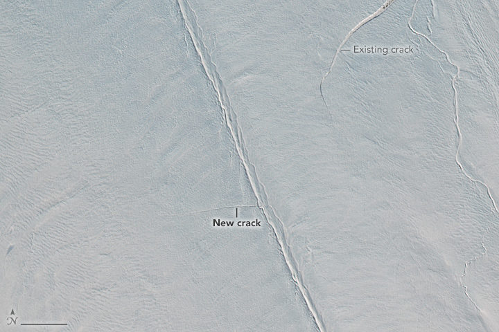
In early April, remote sensing scientist Stef Lhermitte examined Sentinel-2 satellite images and saw a new crack developing on Greenland’s Petermann Glacier. About two weeks later, Landsat 8 also got a look (top image). Read more about that image here.
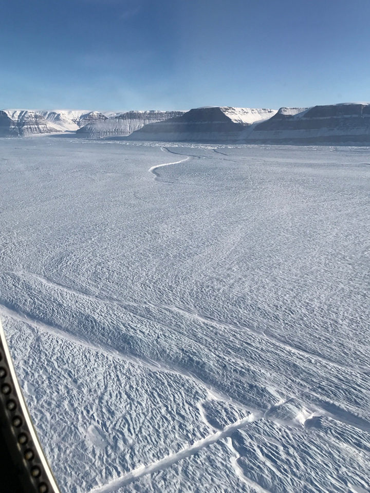
But the space-based view is not the only evidence of a new crack in the large glacier. NASA’s Operation IceBridge has been making science flights in the area this month, and scientists got a first-hand look. Kelly Brunt, a glaciologist at NASA’s Goddard Space Flight Center, snapped the photograph above from a window of a P-3 Orion research plane on April 14. The new crack is the feature running diagonal from the bottom-left of the photo toward the center.
“What’s interesting here is that the crack originated in the center of the glacier, not along the edges,” Brunt said. “When John Sonntag and I were looking for the new crack during the flight, we were looking for something substantial emanating from the edge. This totally surprised me!”
Most cracks start along a glacier’s edge, where a huge amount of strain is produced as the glacier slides along the walls of a fjord. That is especially true for Petermann—a narrow glacier that has previously rifted along the edges of its floating shelf.
Cracks that make their way across an ice shelf can eventually release icebergs. Petermann has launched two huge icebergs since 2010, so scientists are watching for additional retreat. It remains to be seen whether this crack will result in an iceberg. If the crack continues to lengthen, it could potentially meet the older rift at the edge of the glacier, visible near the top-center of the photo.
View more images of the rift and other icy phenomenon here.
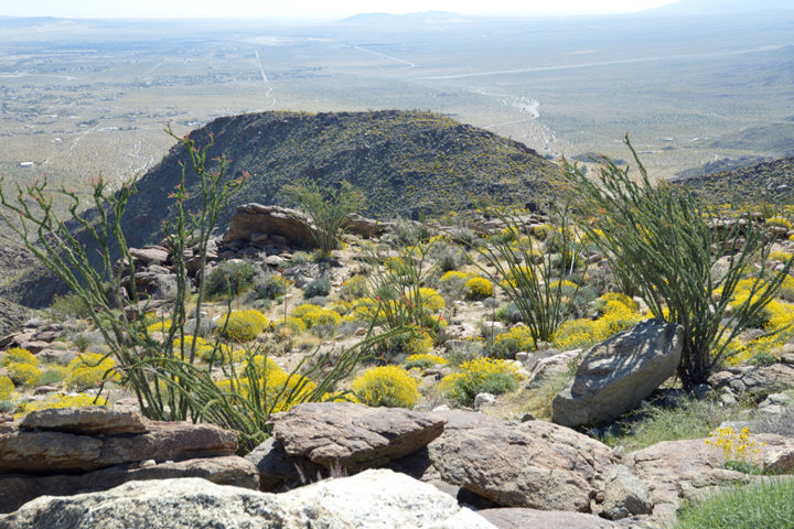
Photo by Ray Boren.
In late March 2017, California’s Colorado Desert sprang to life with vegetation following a period of ample precipitation. From space, imagery acquired on March 23 showed a widespread green up. From the ground, photographs from the same area showed the greenery topped with vibrant blooms.
Writer and avid amateur photographer Ray Boren was on location in Anza-Borrego Desert State Park to witness peak bloom, but not without a little trial and error in timing. He shared some photographs and a brief description of his journey.
“I first visited Anza-Borrego last year, in early May—a little late, I discovered, to catch the blossoms at their peak (though there were a few even then). It was already hitting 100 degrees there ….
So, when I heard that this year’s “super-bloom” in California’s largest state park was even better—enhanced by drought-busting winter and spring moisture—I had to dash the 800 or so miles from my Utah home to see what I could see. I did so with my sister Elaine, and we were well rewarded.
These photographs are from a drive through Anza-Borrego on a beautiful, even “cool” Monday, March 27, 2017.
The vista (top photo) is from Anza-Borrego’s granite mountains, which basically form a north-south spine through the huge state park. The view is from a turnoff on S22, a San Diego County road toward the park’s north side, and is looking east. From this point, you can look down upon the community of Borrego Springs, which is where Anza-Borrego’s visitor center is located (and which is quite recognizable in the satellite photos NASA Earth Observatory used as an Image of the Day).
The yellow flowers, which blanket the sunny slopes, are I believe California trixis. Gangly, multi-limbed ocotillo, with their flowering red tips, are common in the park, and they are having a grand spring.”
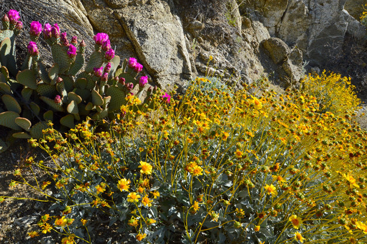
Photo by Ray Boren.
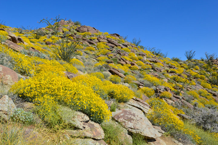
Photo by Ray Boren.
“Pictured in other photos, from the same S22 route, are beavertail cactuses, with their brilliant pink-lavender flowers just beginning to pop. The super-bloom seems most dominant on the north side of the park (we also drove south, to see the badlands). The garden at the visitor center is bursting with color, including such lovely plants as wolf’s cholla, barrel cactus and California’s squat but beautiful fan palms. We even saw a couple of Anza-Borrego’s iconic Peninsular desert sheep (“borrego”) on the ridges.
During our journey, we also saw desert flowers near the border with Nevada and Arizona, and were amazed by the bountiful show under way at the Antelope Valley California Poppy Reserve near Lancaster, which we visited on the way home.”
The Anza-Borrego Desert without wildflowers blooming. This image was acquired by the Operational Land Imager (OLI) on Landsat 8 on March 20, 2016. Learn more.
The Anza-Borrego Desert during a wildflower bloom. Notice the greens and purples around Borrego Springs. This image was acquired by the Operational Land Imager (OLI) on Landsat 8 on March 23, 2017. Learn more.
NASA Earth Observatory image by Joshua Stevens, using Landsat data from the U.S. Geological Survey.
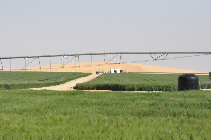
Cultivated desert. Photo by Ragab Hafiez.
In early March 2017, we featured the top image as our monthly satellite puzzler and as an Image of the Day. But sometimes we learn even more about an image after we publish, as people write to us with a local or personal connection to the place. That was the case here.
Local knowledge is especially important when it comes to agriculture. Ragab Hafiez, a hydrogeologist and geologist working for DASCO, studies Egypt’s Western Desert. He gave us permission to re-publish some of his photographs showing the ground-based view of East Owinat, one of Egypt’s land reclamation projects aimed at making some desert areas suitable for agriculture. He also took the time to answer some questions about the satellite image that inspired the puzzler.
Q: What features visible in these images strike you as interesting?
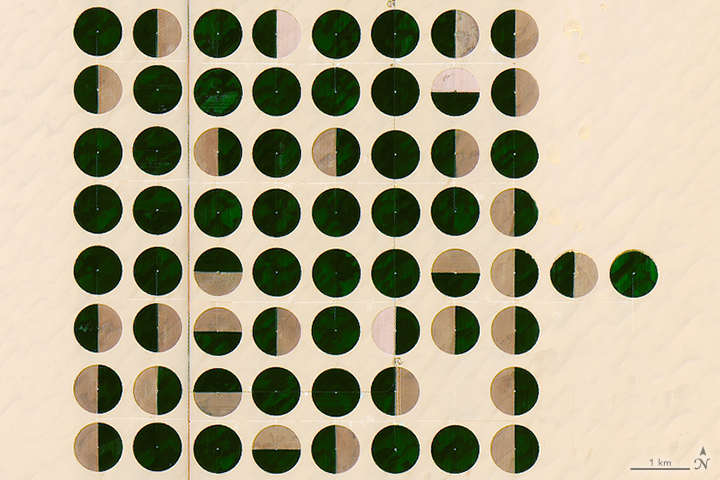
A: The features visible in these images are the irrigated crops mainly clustered in a center-pivot irrigation systems; the diameter of the pivots range from 700 to 820 meters. The total irrigated area at the beginning of this year was about 79,000 hectares.
Q: Is there anything not visible that is worth noting?
A: East Owinat is an interesting area located at the far south of Egypt. It’s an arid to hyper-arid area, the rainfall is nil, and fossil groundwater is the only source of water in the area.
The area is covered with a thin sheet of loose sand, followed by the thick sandstone rock bed. The sandstone beds belong to the Nubian sandstone formation deposited through the Lower Cretaceous and Jurassic periods.
The water wells in the area are usually drilled to depths of 200 to 350 meters (650 to 1150 feet) below the ground surface. The water level ranged from 30 to 60 meters (100 to 200 feet) below ground.
Q: Do you happen to know what crops are planted here, and the reason for the various green/brown patters?
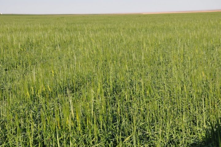
A: The crops cultivated in the winter season are wheat, barley, potatoes, and alfalfa. Virgin soil, fresh water (salinity less than 700 parts per million), mild weather, and long daily sunlight hours are all factors that combine to produce high-quality and prolific crops.
The green areas are currently cultivated, while the brown areas are left without cultivation this season.
Wheat fields. Photo by Ragab Hafiez.
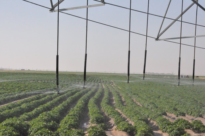
Potato fields in the desert. Photo by Ragab Hafiez.


It might seem unlikely that vegetation can survive in a sandy coastal environment that receives little rain, but plant communities along Peru’s southern coast have found a way.
In December 2016, we published the top image showing a unique perspective of fog. From space, you can see the vast expanse of marine stratocumulus sweeping inland to fill some of Peru’s deep valleys. It is the visible outcome of unseen atmospheric circulation and ocean currents.
From the ground, visibility would be limited (assuming the cloud layer is reaching all the way down to the ground). Depending on your location, experiencing fog might not be too unusual. In coastal Chile and Peru, it’s most common to get fog like this during the austral winter (June through August) and early spring. Plant communities called “lomas” depend on it for their survival. Instead of relying on rainfall, the plants get much of their water by combing droplets out of the air as dense fog passes by.
Ralf Hesse, a scientist at the State Office for Cultural Heritage in Germany, has used remote sensing to study Peru’s lomas. He provided the second image above, which shows the view from a study site located about 80 kilometers (50 miles) northwest from the top-left corner of the satellite image. The loma pictured is composed of the species Tillandsia. But depending on the location, lomas can contain anything from grasses and shrubs to small trees.
Three thick layers of cake and frosting sat atop Jeff Schmaltz’s kitchen counter. The programmer had completed a 3-D model of a GIBS tile pyramid; it was his entry into a collegial science bake-off at NASA’s Goddard Space Flight Center. But there was more to this cake than flour and eggs and sugar.

This tile pyramid cake shows a view of the world with Antarctica represented as the largest continent on the map. Credit: Susan Schmaltz.
If you have ever browsed Earth science imagery and data using the online tool Worldview, then you have also used GIBS, Global Imagery Browse Services. GIBS is like a gear behind a clock face, a mechanism that keeps the hands moving. Schmaltz and his colleagues rely on it daily as they assemble images of our dynamic planet. (Worldview is a free and publicly available Earth science browser used by scientists and non-scientists, including the NASA Earth Observatory team.)
How It Works
GIBS ingests and organizes satellite data to create a global mosaic. Then, it chops down the data into digestible bits—like that image tile pyramid that Schmaltz recreated with cake—so that users can quickly view Earth as seen from space.
Zoomed out in a broad view, you see just the top tile, the whole Earth in low resolution (like the top layer of the cake). Zoomed in, you see one tile covering a smaller region of the earth but in more detail (like a square from the bottom layer of the cake). On an interface like Worldview, which allows users to scroll and view daily images from the entire surface of Earth, an architecture like GIBS is necessary to keep the site running quickly.
“It’s very fast, and there’s not a lot of computing going on,” Schmaltz said. GIBS does the same thing that Google Maps does: it summons only the data the user requests. By dealing in tiles, the program can serve many people at once without getting bogged down.
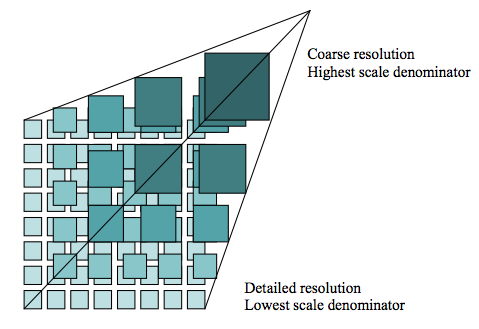
GIBS uses tiles (512 x 512 pixels) to speed up data processing. Credit: The Open Geospatial Consortium (OGC).
Way Back When
Not long after NASA launched the Terra satellite in late 1999, the U.S. experienced a record fire season: A record 8.4 million acres burned in the year 2000. At the time, it could take weeks for data from Terra’s MODIS instrument to be processed into images. Scientists hoped that a quicker turnaround might translate into a more informed response to fires. As result, NASA created a near-real time fire pixel product.
Seventeen years later, scientists can visit Worldview to see roughly 150 near-real time data sets from different satellites and sensors as the clouds and snow cover change each day. Air pollution, vegetation cover, dust, smoke are just a few of the data layers users can view.

Credit: NASA.
P.S. To make Jeff’s satellite cake, follow his grandmother’s recipe below:
Ingredients:
Directions:
Mix dry ingredients together. Measure oil, water, egg yolks, and vanilla into a measuring cup and mix; then add to dry ingredients and beat until smooth.
Beat 2 egg whites + ¼ tsp. cream of tartar until stiff. Fold into batter. Slowly mix in grated chocolate.
Bake in ungreased 8×8 pan at 350 degrees for 20-25 minutes. Check with toothpick when done. Cool on a rack. Goes best with chocolate frosting. (Schmaltz uses the recipe on the side of a Hershey’s can.) Alternately, you can top the cake with an edible print of a satellite image.

Credit: Adam Voiland.

Photo by Adam Voiland. Taken from Rodeo Beach in Marin County, California, in the evening on December 14, 2015.
If you have ever stood on a beach before sunset and gawked at a gleaming line of light extending toward the horizon, you have seen a glitter path.
What causes this spectacular optical phenomenon? Glitter paths are made up of many bright points of light reflecting off tiny ripples, waves, and undulations on the water surface and back at a sensor (for instance, a camera or human eye). Together, these points of light make up areas of sunglint. The appearance of glitter paths on water varies depending on the height of the Sun above the horizon, the height of the surface waves, and the position of the observer.
For instance, if the Sun had been directly overhead and above perfectly calm water, I would have seen a circular reflection that looked much like the Sun in the sky. However, when I took this photograph from Rodeo Beach near sunset in December 2015, the reflection appeared as a long elliptical line of light because the Sun was quite low in the sky. Note how much the roughness of the water surface affected the glitter path. Near the shore, where waves had just broken and the water surface was filled with foam, the glitter path was significantly wider than it was in the smoother waters farther off shore.

NASA image acquired by the Moderate Resolution Imaging Spectroradiometer (MODIS) on the Terra satellite on the morning of June 22, 2015.
Sunglint is visible from space as well. In the satellite image of California above, which the Terra satellite captured on the morning of June 22, 2015, notice the line of light running over the Pacific Ocean. This line of sunglint traces the track of Terra’s orbit. If the ocean surface had been completely smooth, a sequence of perfect reflections of the Sun would have appeared in a line along the track of the satellite’s orbit. In reality, ocean surfaces are chaotic and often in motion due to the constant churn of waves and winds. As a result, light reflecting off the surface was scattered in many directions. This left the blurred, washed out line of light along the satellite’s orbital track that you see here instead.
You can learn more about sunglint and glitter paths from stories by Darryn Schneider, Atmospheric Optics, Joseph Shaw, Richard Fleet, NASA Earth Observatory, and Earth Science Picture of the Day.
Editor’s Note: Ground to Space is a recurring series of posts on NASA Earth Observatory’s Earth Matters blog that pairs ground photography and satellite imagery of the same feature or phenomenon. If you have a photograph that you think would be a good candidate, please email Adam Voiland.
Technically, there are not any antelope on Utah’s Antelope Island, the largest island in the Great Salt Lake. Rather, some 200 pronghorn (which fill a similar ecological niche as their Old World counterparts) and 300 mule deer live on the island in the southern part of the lake.
Despite the name (attributed to explorers John Frémont and Kit Carson), Antelope Island is perhaps best known for its free-ranging bison herd. Four breeding pairs were introduced to the island in 1893, a period when hunters had pushed bison toward extinction across much of North America. The lack of trees and abundant grass made the 24 kilometer (15 mile) long and 8 kilometer (5 mile) wide island ideal habitat for the largest land animal in North America. Now, park managers have to remove a few hundred bison every year to keep the population at sustainable levels (between about 500 and 800). See the video below, produced by the Salt Lake Tribune, to learn more about the island’s annual bison roundup.
The landscape and geology of Antelope Island offers much of interest as well. The island is comprised of several different rock formations that represent a range of geological processes. The oldest rocks on the island—gneiss, a coarse-grained, irregularly banded metamorphic rock—formed between two and three billion years ago when sedimentary rocks such as claystone and siltstone were squeezed under extremely high temperatures and pressures. The island’s youngest rocks (tufa limestone) formed when calcium carbonate precipitated from Lake Bonneville about 10,000 to 15,000 years ago.
Ray Boren, a photographer and retired journalist, stopped by the island on December 23, 2015. “I love to go there when I’m out and about,” Boren said in an email. “It is a wonderful rural setting within shouting distance (well, not quite) of the millions of people living along Utah’s Wasatch Front.”
It was a chilly, windy day. “I’ve come to see what’s happening on the island,” Boren told a worker at the park entrance. “You mean, besides the wind?” she replied. Indeed, strong prevailing winds out of the northwest and west were whipping loose snow across the causeway and the island roads, creating intermittent drifts and icy conditions. Even more dramatic was the effect on the island’s shores, benches, plains and mountainous central ridge.
In the photo at the top of the page, originally published by Earth Science Picture of the Day, snow streamed through a boulder field on the island’s northeast side. “The Sun is beginning to set, and the light’s low angle and longer wavelength colors help tint the scene. In the photograph below, snow is being stirred in ephemeral waves, swirls and columns off the jagged terrain of Frary Peak, the island’s highest point at 6,596 feet (2,010 meters).”
For a different perspective on Antelope Island, I dug into the Earth Observatory archives for the images below. Acquired by the Multi-angle Imaging SpectroRadiometer in 2001, the pair offers a winter and summer view of the island. In addition to the obvious difference in snow cover, note the contrasting water color in the northern and southern part of Great Salt Lake. The different colors are the result of a rock-filled causeway built in 1953 to support a permanent railroad. The causeway decreased circulation between the two arms, producing higher salinity on the northern side. If you look closely at the full resolution image, you should be able to see the causeway connecting the island to the mainland.