
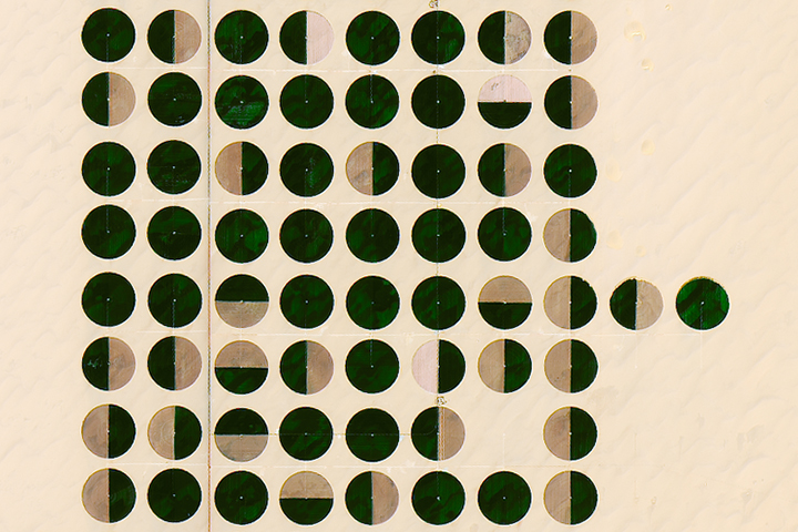
Every month on Earth Matters, we offer a puzzling satellite image. The March 2017 puzzler is above. Your challenge is to use the comments section to tell us what part of the world we are looking at, when the image was acquired, what the image shows, and why the scene is interesting.
How to answer. Your answer can be a few words or several paragraphs. (Try to keep it shorter than 200 words). You might simply tell us what part of the world an image shows. Or you can dig deeper and explain what satellite and instrument produced the image, what spectral bands were used to create it, or what is compelling about some obscure speck in the far corner of an image. If you think something is interesting or noteworthy, tell us about it.
The prize. We can’t offer prize money or a trip to Mars, but we can promise you credit and glory. Well, maybe just credit. Roughly one week after a puzzler image appears on this blog, we will post an annotated and captioned version as our Image of the Day. After we post the answer, we will acknowledge the person who was first to correctly ID the image at the bottom of this blog post. We may also recognize certain readers who offer the most interesting tidbits of information about the geological, meteorological, or human processes that have played a role in molding the landscape. Please include your preferred name or alias with your comment. If you work for or attend an institution that you want us to recognize, please mention that as well.
Recent winners. If you’ve won the puzzler in the last few months or work in geospatial imaging, please sit on your hands for at least a day to give others a chance to play.
Releasing Comments. Savvy readers have solved some of our puzzlers after only a few minutes or hours. To give more people a chance to play, we may wait between 24-48 hours before posting the answers we receive in the comment thread.
Good luck!
Editor’s Note: Congratulations to Italo Moletto-Lobos, Mark D, Peter Upshall, and Avinash Wagh for being the first readers to solve the puzzler on Earth Matters and Facebook. Special mention goes to Mark D and James Varghese for their thorough explanations. See a labeled version of the March puzzler with a detailed description of central-pivot irrigation in Egypt’s Western Desert here.
So agricultural irrigation testing in …
Central pivot irrigation farm fields near Hail in Saudi Arabia
There crops in a desert
grape plantation of Namibia.
It is agricultural field in USA, i guess near arizona
this is a farm land in deserts of saudi arabia which also helps water conservation.
Center-pivot irrigated farms in the deserts of Saudi Arabia (or thereabouts)!
I guess Its movement of satellite day night zone of earth at specific time .
The images shows Center pivot irrigation system generally practiced in some states of USA and in some parts of Africa. The center pivot irrigation systems is said to be the most significant mechanical innovation in agriculture since the replacement of draft animals by the tractor.
I think that imagen is in the Egypt, taken with Visible colors spectra (Red-Green-Blue). The image is interesting because shows the existence of vegetation in a extreme ecosystem like dessert thanks to the use of water (probably groundwater) and the beauty of green mosaic through circles points showing us a beautiful landscape seen from space
Ground to Earth!!!
From the colour of the white sands, I am guessing this is in central to northern Saudi Arabia.
Very similar to agricultural fields in the Nile delta, not far from Ismailia.
There are also fields like that in the western edges. It looks like experiments with center pivot irrigation.
I’m intrigued by the semi-circles. Do you think they are leaving half of the field fallow?
Also, I was looking at this with some of my students (who think farming in the desert is mad).
I said I guessed it was the equivalent of greenhouse farming, just without the need for glass houses. Do these guys have to import all their soil, as well as the water?
The image looks to be from the northwest quarter of Saudi Arabia. It seems that it is the middle of harvest time. Maybe early spring, depending on the weather, rainfall. The image shows centre-pivot irrigation. In the early eighties there were only a few fields, now there are many. Impressive to fly over. It is interesting, because it is in the middle of the desert with dry wadi beds. These wadis also mean occasional flash floods which may resupply cisterns (underground reservoir in porous rock). Otherwise water needs to be transported in by pipeline. Why there? Probably because it is arable land.
This is in southern Egypt, about 200km south west of the Toshka Lakes (22°31’19 N, 28°14’39 E).
The (true-colour MODIS?) image shows an area of very organised centre-pivot irrigation in a desert, with faint traces of linear dunes around the irrigated circles. These are addictive! I hunted around the deserts of N.Africa, the M.East, N.Asia and N.America before finding this place.
I guess it is part of the $70bn South Valley Development Project, an attempt by Egypt to divert some of the Nile’s water to irrigate and settle the otherwise barren desert. The aim being to relocate up to 16 million people, increase agricultural output and reduce unemployment. Interesting use of water in this era of concern over the stewardship of that precious resource…
The problem with this image is that the features may no longer be exactly the same. Center – pivot fields are common in several places, like Northern Africa, Saudi Arabia, and areas of the United States. The areas tend to be fairly arid and the color of the ground not in the fields suggests a fairly uniform pale sand. The most similar I have found is near Wadi Aldwasir in Saudi Arabia. I have not found the exact configuration of fields as I have scanned areas in Google Earth, but I have noticed as you zoom in and out, that the placement changes, as does the color of the sand. So unless the image in Google Earth was taken when it’s image was taken, there is no guarantee they will look the same.
The image looks to be a true color image, so probably RGB, or even a camera from shuttle or ISS. It would appear to be at least late spring, as plants have gone green, and may be much later since some of the fields are golden, which might be them drying out ready to harvest.
Egypt western desert west of Nile river growing wheat.
The images are Cultivating Egypt’s Desert and were taken on February 26, 2017 by the Operational Land Imager (OLI) on Landsat 8. The natural-color images are of East Oweinat, one of Egypt’s land reclamation projects.
This is imagery taken of East Oweinat, in the Western Desert of Egypt – taken February, 2017, showing center-pivot irrigation. Unfortunately, the water being pumped from the central wells and going into the irrigation system is likely Pleistocene in age. This form of irrigation is great as long as the water lasts, but it’s not going to be recharged at anything approaching the rate at which it’s used. In this environment as well, direct evaporation will be an enormous loss.
https://earthobservatory.nasa.gov/IOTD/view.php?id=89820&src=eoa-iotd
Campos de cultivo con pivote central de riego en Egipto
The images are circular irrigation method called DRIP IRRIGATION using circular sprinklers.
This image shows many things: –
1) To highlight ART BEAUTY in Agriculture
2) Water efficient use in places where water is scarce.