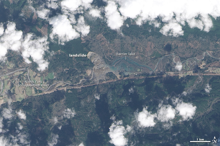
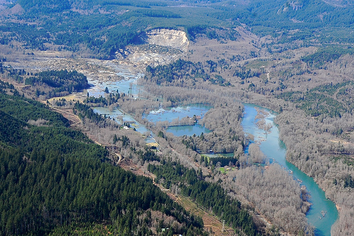
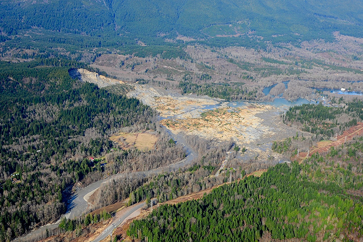
On March 25, 2014, we published this nadir view of debris and a barrier lake created by a major landslide near Oso, Washington; the image was acquired by the Landsat 8 satellite on March 23. While top-down satellite views are Earth Observatory’s specialty, such images can be challenging to interpret because of how foreign the scale and topography appear from above as compared to how we normally see the world from the ground. To help make the nadir perspective more intuitive, I try to share matching aerial or ground photography when it is available. The set of images below, originally published by the office of Washington State Governor Jay Inslee, was taken during an aerial survey on the same day that Landsat 8 acquired its image. For more photographs of the landslide, visit Inslee’s Flickr page.


Wow, the earth is powerful!!
Sad. Rumor is that someone predicted this based on science. Still sad. K
Many people perished here. Some lived here, others were visiting, working, or just driving through the wrong place at the wrong time. Some have been recovered, others may never be found. Certainly there was a history of small slides here, but everyone takes a chance at the tradeoffs in life. Look at California with another earthquake tonight, the Midwest with tornadoes, or any coast for storms. This is my neck of the woods, and we have few natural disasters here. I think the majority of residents will agree that the natural beauty is worth it. My heart goes out to my friends who have lost everything. For them, I doubt it was worth it.
Looking at these pictures, it looks like it’s repeated itself time and time again all along this valley.
This should not happen. Mass wasting events are often ignored. There was a real dereliction of duty to convince those residents to relocate. Ignorance is not bliss.
I’d be curious to know if the pattern Mark is referring to is from previous landslides or due to clearcuts, as this is, historically, a logging community. Could deforestation also have contributed to the weakening of the soil and further below, the chemical weathering and weakening of rock underneath?
There was some 2nd growth trees in the slide area. Looking at the satellite and aerial photos from pre-slide and post-slide orientations, there appear to be MULTIPLE SLIDES, some perhaps thousands of years old. A geomorphology class (land-shaping features) would describe the terrain as “hummocky”, indicating previous slides had occurred. The Stilliguamish River expressed several channel changes, probably as a function of prior “historic” slide activity. These hummocky features are not uncommon in relict glaciated terrains where steep sided valleys are narrow, and exhibit an active river that continues to downcut the valley floor. The White Horse Glacier is located just a few miles upstream to the East and feeds the Stilliguamish River. I hope this answers some of your questions. I am a former college Geology Instructor and currently a Registered Professional Geologist. Denise C.
This area of the valley is littered with slides. Logging certainly doesn’t help the hillsides stay together, but most of the large slides in this area predate white settlement. These slides have been happening for the last 12,000 years.
The sides of the valley in this particular area are especially slide-prone because they’re made up of glacial lake sediments (largely sand with sections of clay mixed in). In the second image, where the camera is almost directly facing the slide, you can see the large flat section that is the top of the hill. That’s Whitman Bench. It’s one big sandy lake deposit. The south side of the valley has the same thing and the two were most likely connected as one large deposit before the river carved a path between them.
Jamie, I didn’t see your comments before I placed my blog. I agree completely, but I was not familiar with the local / regional geologic formation names. Good job Denise C.
Its all God’s deeds……He does everything at His will……..well, science has nothing to do in His deeds. We can only predict happenings, but can’t stop them from happenings. It is sad for all of us and worst for those living and visiting this place.
I lived in Oso, WA in 1968 in a white house immediately adjacent to the North of the Covered Wooden Bridge on the west side of the road. That narrow paved road began at the Oso General Store on the Highway (between Arlington and Darrington) and traversed South across the old wooden bridge to areas across the river that lay at the foot of the Slide. Essentially, we lived in a farm house located on the NE side of the covered bridge and the Stilliguamish River formed the southern boundary of our leased property.
Now, I am a multiple-degreed Registered Professional Geologist (TX). I immediately recognized the mountain scenery, and when HLN News revealed a photo of the old shake shingle covered bridge exposed by only 3 feet of roof and white boards located a few feet away, I knew that my former house had been inundated by the slide. Yes, it freaked me out!!! I have seen former neighbors (3) being interviewed on television, and I wonder how many more persons that I had known who were victims. My absence of 45+ years have not dimmed my impressions of that beautiful area. I rode horses on the truck trails in the general area of the Slide, and swam horses in the exceptionally clear waters of the Stilliguamish River. The residents there were simple, unassuming people, and I DO NOT BELIEVE they had been properly informed of the geologic dangers.
From the photographs, it appears the cliffs were composed of unconsolidated glacial till/deposits. I also wonder whether an undetected fault may have initiated a canyon, later filled by glacial deposits. I state a potential canyon, as the hills and peaks on the East and West sides were higher in elevation, and expressed rock outcrops not seen in the strata of the exposed scarp. The 1.1 Magnitude earthquake that occurred a couple weeks before MAY have assisted in the destabilization of that slope. Not mentioned by news sources is the Hebgen Lake Slide that occurred in the late 1950s in WY or Montana, when the dipping rocks of the Paleozoic Madison Formation became super-saturated and slid into a canyon in a State Park following a moderate earthquake. A comparison would make a good Master’s Thesis. I pray for the survivors and for those who lost their friends and family members. They were good people.
Hello Denise,
I am not a geologist but a student of nature with an engineering technical design background. We have friends who lost 4 family members in the slide and a neighbor down the hill that lost their brother and sister-in-law. We are so sad and sorry for all the people who lost their lives, members of their family, friends and for the community of Oso.
It seems like a lot of people are wanting to set blame but as you state this is an historic geologic event in an area where major events are a norm and not an exception. Our lives and even the history of our nation are short in comparison to geologic time.
You may have already seen the topo comparisons of the slide. There are houses that built on the old debris field of a neighboring slide that looked larger than the March 22 event and were not affected. Looking at the topography previous to March 22 without vegetation I can see the soft weathered edges of several events and the sharper edges of more recent slides. I also see what appears to be some slip fault lines in the shape of an arc (my words since I don’t know the proper geologic terms) on the projection of the moraine that was left hanging out there and that slid on 3/22.
In my amateur opinion the projection was getting ready to go for a long time and now there is a point left that will want to slide sooner than later. I am putting the link to the topo pics that have a slide feature so you can compare them. It is from the article in the Washington Post. Am I correct in my theory that the land was showing it’s instability and preparation for the 3/22 event?
Cindy
http://apps.washingtonpost.com/g/page/national/washington-mudslide-before-and-after/893/
I don’t know what structures you saw pictured on HLN, but there haven’t been any covered bridges in the area for decades. The Oso Loop Rd bridge is about 3 miles down stream near the Oso Store (store is closed), Whitman Rd bridge is about a mile west of the slide, and C-post bridge is just east of the slide and visible in some of the aerial photos online. None of those are covered bridges.
Here’s an excellent Lidar image of the area:
http://blogs.seattletimes.com/today/2014/04/new-aerial-map-shows-oso-slide-in-a-different-light/
This incident is a very good example for IB geo 12
Please view or download the geologic GIS databases I generated of the Oso landslide area from available public data for public viewing on free Google Earth software. There is also a WADOT aerial posted to compare with the NASA/USGS Landsat image. These are the building blocks for a precise hazard map. It would be democratic for the country to be interested in this.
http://www.geological-assessments.com/Oso_Landslide.html
Be sure to download or view GIS geologic databases of the Oso Landslide generated from available public databases and viewable on Google Earth at:
http://www.geological-assessments.com/Oso_Landslide.html
I just watched Killer Landslides a pbs show about the slide and immediately thought of the Hebgen Lake slide
and was wondering about how they compare size wise. Both are tragic natural events with sad outcomes. We certainly are learning more about this kind of thing worldwide. Love Creek in the Santa Cruz mountains is another with tragic results. These event are really fairly common.