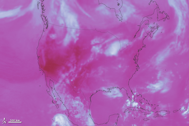


A summer heat wave left much of the United States sweltering in July 2011. On July 22, many cities from Virginia to Maine broke temperature records with highs between 100 and 108 degrees Fahrenheit (38 to 42 Celsius). The heat settled heavily over the South and Midwest as well. Both Texas and Oklahoma experienced their warmest month on record, and some cities, including Fort Smith, Arkansas, and Dallas, Texas experienced temperatures higher than 100 degrees Fahrenheit (38 Celsuis) nearly every day of the month.
If the human eye could see the heat radiating out of the United States, it would look like this image. It is a measure of outgoing longwave radiation (heat) as seen by the Clouds and the Earth’s Radiant Energy System (CERES) instrument on the Terra satellite on July 22, 2011, at the peak of the heat wave. The areas releasing the most heat are nearly red, while cooler areas are white. The coldest areas in the image are clouds.
The image depicts what happens to energy from the Sun when it reaches Earth. Some of the energy evaporates water, and some heats the atmosphere, land (including everything on it), and ocean. The heated surfaces radiate energy back into space, and it is this radiated heat that is recorded in this image. The rest of the Sun’s energy reflects off clouds or ice and other bright surfaces.
Though the worst of the heat wave occurred in the Midwest, South, and East, the western desert and southern plains are radiating the most heat in this image because the exposed rock and soil absorb and release heat directly. In other parts of the United States, rock and soil are covered with forests and grasslands where more energy from the Sun evaporates water or causes plants to release water (transpiration). Since more of the Sun’s energy goes to evapotranspiration where plant growth is thick, the land absorbs and radiates less heat, and thus appears cooler in this image.
Throughout July, a high pressure system over the southern plains allowed heat to build in the atmosphere. In mid- to late-July, the atmosphere began to channel this extremely warm air north and east, causing the record-breaking heat wave.
In the winter, when sunlight is less direct, the United States will absorb less solar energy and will emit less heat. Though the exact amount of heat going into space varies from day to day, over time, this measurement averages out to a figure that has been fairly steady. It is Earth’s temperature.
The temperature on any planet, including Earth, is controlled by energy from the Sun. The Sun provides an average 340 Watts per square meter to the Earth. That energy returns to space as either reflected energy or radiated heat. Over time, the total outgoing energy should equal the amount of energy coming in from the Sun. When incoming and outgoing energy don’t balance, Earth’s temperature will change until balance is restored.
Decades of measurements from CERES and similar instruments have revealed that Earth’s energy budget is not in balance. Earth is receiving more energy than it is sending back to space. This means that the planet must heat up—and in fact, already is heating up—to regain balance. Since heating affects both temperature and evaporation, we see that change in more frequent heat waves and in more intense storms.
NASA Earth Observatory image created by Jesse Allen, using CERES data provided courtesy of the NASA Langley Atmospheric Science Data Center. Caption by Holli Riebeek with information from Takmeng Wong, NASA Langley Research Center.