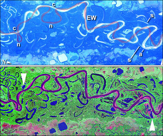


The Mamore River drains north from the Andes Mts. in lowland Bolivia. An image taken in July 2003 from the International Space Station (ISS007-E-10797, 14 June 2003, 12:36 GMT) shows an 85 km stretch of the river south of the lowland town of Trinidad in the Beni Province. A 55-km stretch (centered at 15.2°S 66°W) was rectified to the commercially available 1990 edition of the Landsat TM imagery of the world.
Numerous changes in river pattern are visible in the decade since the Landsat imagery was acquired. A pilot study was undertaken to characterize these rapid changes. Tie points were selected for geomorphic features which do not undergo short-term change- i. e. oxbow lakes and subsidence lakes in the floodplain. The ISS image was enhanced slightly to reveal the Mamore River channel.
The ISS image (top) shows Mamore River meandering in a floodplain with numerous contorted channel traces indicating former positions of the river. The darker areas are riverine forest, the lighter areas tropical savanna. The river trace as it was in 1990 (bottom) is superimposed on the 2003 handheld image.
The Mamore River drains north from the Andes Mts. in lowland Bolivia. An image taken in July 2003 from the International Space Station (ISS007-E-10797, 14 June 2003, 12:36 GMT) shows an 85 km stretch of the river south of the lowland town of Trinidad in the Beni Province. Numerous changes in river pattern are visible in the decade since Landsat imagery of the same area was acquired.
Image of the Day for August 18, 2003
Astronaut photograph ISS007-E-10797 was taken with a Kodak DCS760 digital camera equipped with a 180 mm lens and provided by the Earth Observations Laboratory, Johnson Space Center. The International Space Station Program supports the laboratory to help astronauts take pictures of Earth that will be of the greatest value to scientists and the public, and to make those images freely available on the Internet. Additional images taken by astronauts and cosmonauts can be viewed at the NASA/JSC Gateway to Astronaut Photography of Earth.