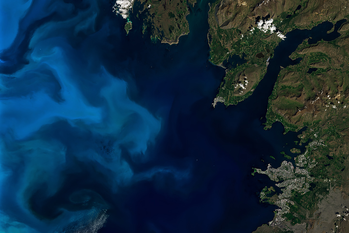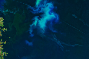
Since May 2024, satellite images have hinted at a phytoplankton bloom developing off the coast of southeast Greenland. But a near-constant stream of clouds prevented optical sensors from getting a clear look. That changed in mid-June, when a short-lived gap in the clouds over the North Atlantic Ocean exposed the bloom’s colorful swirls.
The bloom is visible in this image, acquired on June 16, 2024, with the MODIS (Moderate Resolution Imaging Spectroradiometer) on NASA’s Aqua satellite. The image shows an approximately 800-kilometer-wide patch of the North Atlantic Ocean centered east of Greenland and south of Iceland. The bloom stretches many more hundreds of kilometers beyond the edges of this image.
A bloom is essentially an abundance of phytoplankton—tiny, plant-like organisms that often float near the ocean surface. Phytoplankton fuel the ocean by feeding other plankton, fish, and ultimately bigger creatures. They are also important carbon cyclers and oxygen producers.
The type of phytoplankton present in this bloom cannot be identified based on this natural-color image alone. The bloom might contain coccolithophores, which are plated with white calcium carbonate that can give the ocean a milky hue. It could also contain diatoms, a microscopic form of algae with silica shells and plenty of chlorophyll, which has a green pigment.
Whichever species composed the bloom that peeked from between the clouds that day, their presence was timely. Blooms often show up first at lower latitudes and then appear at high latitudes in the North Atlantic by spring and mid-summer.
NASA Earth Observatory image by Lauren Dauphin, using MODIS data from NASA EOSDIS LANCE and GIBS/Worldview. Story by Kathryn Hansen.