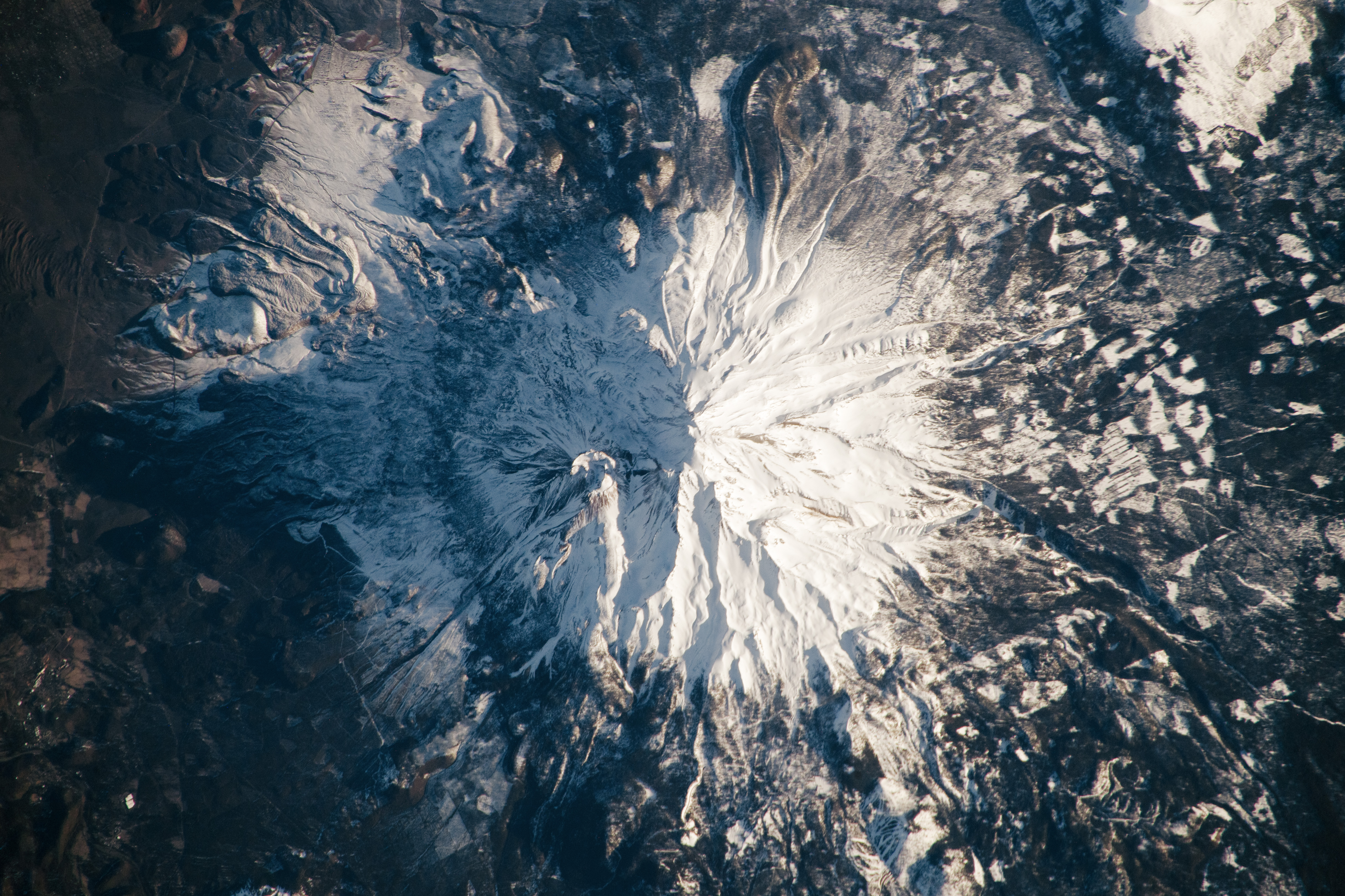
An astronaut aboard the International Space Station took this nadir photograph of Mount Shasta as the station passed over California. Mount Shasta is a 14,179-foot (4,233-meter) peak situated between Redding, California, and the Oregon-California border. Shasta’s slopes are at least partially snow-covered year-round. A more extensive snowpack during winter makes the mountain’s seven glaciers difficult to distinguish.
Mount Shasta is a stratovolcano constructed during four cone-building episodes, each separated by periods of less frequent central-vent eruptions (near the present peak) and flank-vent eruptions. Each of the four episodes of volcanism that formed Mount Shasta originated from separate eruptive centers, with two occurring approximately 9,000 to 10,000 years ago near Shastina and Hotlum Cone (located beneath Hotlum Glacier). Black Butte, located southwest of Mount Shasta (just off the bottom-left side of this image), was formed approximately 9,500 years ago when a series of flank-vent eruptions produced overlapping dacite domes.
Volcanic activity at Mount Shasta produced andesitic lava flows in addition to mudflows and block and ash flows. These collective eruption events produced 350 cubic kilometers (84 cubic miles) of material, making Shasta the largest volcano by volume within the greater Cascade Range.
Mixed conifer forests encircle the base of Mount Shasta and comprise part of the Shasta-Trinity National Forest. The effects of logging are visible as irregular patches of forested and barren land cover. Forest thinning is performed as an effort to make the forest more resilient to pests and decrease the danger of large fires. Silviculture projects within the region have sought to remove overly dense forest stands that are at risk of root rots or destructive crown fires.
Astronaut photograph ISS068-E-53629 was acquired on February 12, 2023, with a Nikon D5 digital camera using a focal length of 500 millimeters. The image was provided by the ISS Crew Earth Observations Facility and the Earth Science and Remote Sensing Unit at Johnson Space Center. The image was taken by a member of the Expedition 68 crew. It has been cropped and enhanced to improve contrast, and lens artifacts have been removed. The International Space Station Program supports the laboratory as part of the ISS National Lab to help astronauts take pictures of Earth that will be of the greatest value to scientists and the public and to make those images freely available on the Internet. Additional images taken by astronauts and cosmonauts can be viewed at the NASA/JSC Gateway to Astronaut Photography of Earth. Caption by Cadan Cummings, Jacobs, JETS II Contract at NASA-JSC.