
Every month on Earth Matters, we offer a puzzling satellite image. The May 2015 puzzler is above. Your challenge is to use the comments section to tell us what part of the world we are looking at, when the image was acquired, what the image shows, and why the scene is interesting.
How to answer. Your answer can be a few words or several paragraphs. (Try to keep it shorter than 200 words). You might simply tell us what part of the world an image shows. Or you can dig deeper and explain what satellite and instrument produced the image, what spectral bands were used to create it, or what is compelling about some obscure speck in the far corner of an image. If you think something is interesting or noteworthy, tell us about it.
The prize. We can’t offer prize money, but, we can promise you credit and glory (well, maybe just credit). Roughly one week after a puzzler image appears on this blog, we will post an annotated and captioned version as our Image of the Day. In the credits, we’ll acknowledge the person who was first to correctly ID the image. We’ll also recognize people who offer the most interesting tidbits of information about the geological, meteorological, or human processes that have played a role in molding the landscape. Please include your preferred name or alias with your comment. If you work for or attend an institution that you want us to recognize, please mention that as well.
Recent winners. If you’ve won the puzzler in the last few months or work in geospatial imaging, please sit on your hands for at least a day to give others a chance to play.
Releasing Comments. Savvy readers have solved some of our puzzlers after only a few minutes or hours. To give more people a chance to play, we may wait between 24-48 hours before posting the answers we receive in the comment thread.
Good luck!
I’m guessing this is Seoul, South Korea, and the darkness to the north is North Korea.
Japan, viewed looking southwest from the International Space Station. The brightly lit city is Osaka. The small very brightly lit area at the upper left side of the image is lightning from a typhoon (Typhoon Dolphin?). The scattered lights in the lower left side of the image are fishing vessels.
harbor at St. Barts, because you would never guess there was so much light at nite
It is East Java looking across Surabaya towards Bali and further islands. The numerous lights in the Java Sea must be mostly fishing boats though the cluster dead center may be partly Pulau Kangean lights. The yellowish isolated light about 3/4 of the way up and left of center must be Makassar. The white flash to its left probably is lightning strike onto West Sulawesi proper. The entire landscape is volcanic in origin, Indonesia being the most vocanically active country in the world, at the junction of 4 tectonic plates.
I completely agree with you, it is interesting to note the circular dark features on the right showing how craters (Mount WIlis, Mount Butak,Mount Bromo and many others) have been poorly settled, obviously. This image has been acquired with a standard camera (Reflex) by the ISS.
Is this Chicago and the surrounding urban sprawl around Lake Michigan?
I agree. The photo is probably taken by the MODIS instrument on the TERRA satellite.
It cannot be a satellite image because you can see the curvature. It is taken with a digital camera from ISS I guess.
But regarding thr location…too difficult!
sono interessato come amante di astronomia, avendo anche un telescopio e avendo scritto un libro a 19 anni di età sul sistema solare e intergalattico, di ricevere molte notizie riguardo alle ricerche NASA
This is the eastern end of Java, Indonesia, looking east. Surabaya is the bright city in the foreground, Bali and Lombok can be seen at the centre right, and the lights from many fishing boats can be seen on the left side of the picture.
OMG, you’re right! It is Surabaya, Madura island and East Java, Bali, Lombok, etc. And mountains in East Java.
But I’m interested at the lights in the Java Sea North of Surabaya and Madura islands! My guess is they’re flares from oil rigs, maybe thousands of them in the entire Java Sea West to East!
Hoping NASA can produce night shots of Java Sea so we can be sure that we’re not being stupefied by oil drillers!
I’m going with Belgium.
it is Tokyo -japan with fishing boats and the island of mount mihara.
According To Me Its England And Near About Places.
Surabaya, East Java is the bright city. Looking East to Bali. ( the first island) The far city before the horizon brightens is Makassar, Indonesia with Fishing boat lights in the Java Sea filling most of the left half of the image, and of course lightning over the Makassar Strait.
could be either Australia and Filipine Islands or……southern east Europe….Greek Islands??
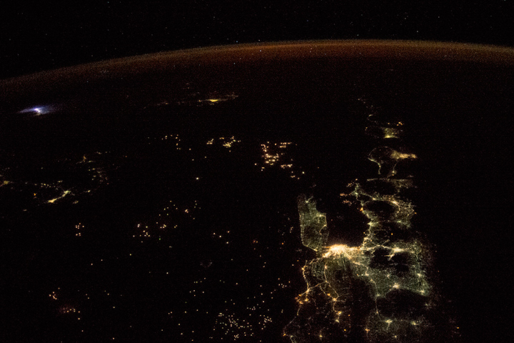
Java, around the city of Surabaya. The image was taken from aboard the ISS flying in WSW direction, approximately around 4am local time on May 22nd, with a commercial camera recording visible light.
Connected lights show the settlements which surround the volcanoes in the region. The singled lights in the central and left area are fishing boats which lure fish to the surface with floodlight. On the far left is lightning. The curvy light at the top of the image is the atmosphere reflecting light from sundawn over the pacific.
ESE* not WSW
claudia
Wow! You must be either working for nasa, or associated with their space station or satellite some how -study/employment. If not you are truely a die hard fan and genius
ESE* not WSW in my previous comment.
Thatvis Surabaya, East Java in Indonesia looking east towards Bali and Lombok.
like United Kingdom of Great Britain and Northern Ireland
Its Java, the dark patterns are the Vulcanos like a chain, the yellow lights are fires from rhoding the Rainforest . The Lightning on the far left is from maybe a Hurricane. The shape of the shorelines are defenetly Java. The light spot between the 2 half-islands is Surabaya.
It is Greece. Kalamata City and Messinian Bay. Picture made from North to South.
Hong Kong looking south. Lights to left are fishing vessels, to right mountains. Glow at top from atmosphere on edge of space. Can see a lightning strike off on left.
Surabaya East Java, Denpasar Bali, Mataram Lombok & fishing boats in Java Sea
Is Surabaya, East Java!!!
I’m guessing Berlin. Dark is former East Berlin, Light is former West Berlin.
it is definitely Surabaya on the Indonesion island of java. You have fishing boats all around which are the specks in the darkness. It’s probably a Landsat image taking in visible light. The unusual light in the top left corner is probably lighting occuring in high altitude volcanic ash.
That is the light in Surabaya City and Malang City in East Java, behind there is Denpasar Bali and Mataram Lombok island, the left side is the light from the fishermen in the Java Sea and the Strait of Makassar, the lights in the city of Samarinda – Borneo and Makassar City in Celebes, and white light is Palu Celebes.
it is definitely Surabaya on the Indonesion island of java. You have fishing boats all around which are the specks in the darkness. It’s probably a Landsat image taking in visible light. The unusual light in the top left corner is probably lighting occuring in high altitude volcanic ash. Since the image is oriented to the east, the orange color in the far distance is sunrise.
It’s mecca in saudia Arabia
Is this Chicago and lake?
This is Java. If the satellite moves straight from the point the picture has been taken then it will head to the Australian continent. So my final conclusion is Java.
Papua new guinea and the surrounding islands………
I am guessing it as Papua New Guinea and the surrounding islands….
I am guessing it as Papua New Guinea and the surrounding islands facing south towards Australia……..
Seattle
I am going to say it is Bangkok looking over the Gulf Of Thailand with the Philippines over to the left and a really nice lightning storm over the South China Sea …maybe.
Surabaya, at Jawa Timur – Indonesia.
Looks like Gulf of Finland and St. Petersburg (bright lights in the foreground). View is looking west toward the daylight portion sky. With the lights of Stockholm and Sweden in the background.
That’s in Surabaya, East Java, Indonesia.
Surabaya, Indonesia with Bali the closest island. Lots of ships and other seagoing vessels.
OMG…
I am from Indonesia. And i just realize it east java like you all said, after i rotate the picture 90 degree clockwise. What an amazing picture from above. Thanks for sharing. I can see East Java, Madura island, Bali island, and Lombok island in a different perspective like this… ^^
Definitely Surabaya, east java-Indonesia
That is my hometown
It’s East Java, Madura Island and Bali Island
the lights shows the big cities, like Surabaya is the brightest, Malang, Denpasar on south of Bali..
i think the lightning on the north side shows the storm around Philipines towards Sulawesi Island
Its ka’bah, in makkah….
Arab saudi