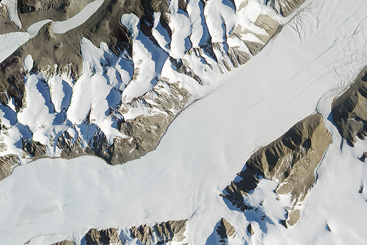
Each month, Earth Observatory offers up a puzzling satellite image here on Earth Matters. The seventeenth puzzler is above. Your challenge is to use the comments section to tell us what part of the world we are looking at, when the image was acquired, and why the scene is interesting.
How to answer. Your answer can be a few words or several paragraphs. (Try to keep it shorter than 300 words). You might simply tell us what part of the world an image shows. Or you can dig deeper and explain what satellite and instrument produced the image, what spectral bands were used to create it, or what is compelling about some obscure speck in the far corner of an image. If you think something is interesting or noteworthy, tell us about it.
The prize. We can’t offer prize money for being the first to respond or for digging up the most interesting kernels of information. But, we can promise you credit and glory (well, maybe just credit). Roughly one week after a puzzler image appears on this blog, we will post an annotated and captioned version as our Image of the Day. In the credits, we’ll acknowledge the person who was first to correctly ID the image. We’ll also recognize people who offer the most interesting tidbits of information. Please include your preferred name or alias with your comment. If you work for an institution that you want us to recognize, please mention that as well.
Recent winners. If you’ve won the puzzler in the last few months, please sit on your hands for at least a few days to give others a chance to play.


I think that’s a (quite nice) image of the Ferrar Glacier’s main trunk, just south of the Dry Valleys in Antarctica. The glacier snout in the top left is the Taylor Glacier, ending in the frozen Lake Bonney. Beautiful!
Oh – I forgot to mention two things. I’m just finishing my PhD studying glaciology and remote sensing at the Scott Polar Research Institute, and starting work at the National Snow and Ice Data Center in Boulder, CO in a few weeks. I’m on Twitter @PopePolar
ALSO – here’s a photo from a flyover of the Taylor Glacier, fieldwork in 2008: https://lh3.googleusercontent.com/-PLp1P51Erp4/SW3JmoBPbfI/AAAAAAAADi8/WklvdH_QdPk/w608-h810-no/IMG_8866.JPG
Ferrar Glacier, Dry Valleys, Antarctica. Lake Bonney is in the top left of the image.
Not sure the image was taken on this date? I stand to be corrected but at this time of the year, Ferrar Glacier (flowing to the right of the image) seems to have no sunlight all day. The picture might have been taken sometime in December 2012, around 9pm (UTC) perhaps? The image is indeed clear (I expect beautifully enhanced). Can this be confirmed?
A big congratulations to Allen Pope (aka @popepolar) for nailing the location almost immediately after we posted the June Puzzler. Like he says, this is an image of Ferrar Glacier in Antarctica.
But that doesn’t mean the puzzler is over. Remember our puzzlers are open-ended. We’re just as interested in having you teach us something interesting or surprising about a particular part of the image — a certain rock formation, glacier, or whatever — as we are in simply getting inundated with coordinates. In fact, we generally try to recognize at least one puzzler player who goes beyond simply giving us the coordinates.
So…what do you all think about what makes this scene interesting?
Adam Voiland
Earth Observatory Writer
Ferrar Glacier is located near the McMurdo Research Station and the Ross Ice Shelf which have had increased public coverage in the past three years. As the regional weather patterns continue to reflect change this summer, climate discussions related to the changes at the poles should continue the focus on this glacier and its neighborhood.
Just a comment from the ‘peanut gallery’:
Knowing little to nothing about glaciers I noticed 3 interesting areas.
1. Just above the dead center of the image, there is a ‘corrugated edge’ to the glacier — from strain of stretching as the glacier makes its gentle right turn?
2. On the right side bottom edge of the glacier, there appears to overriding deposits on the glacier surface — is this from the smaller glacier’s toe being above the elevation of the Ferrar?
3. Directly above the small glacier referenced in #2, there appears to be another small glacier intercepting the Ferrar and it appears to enter a t a lower elevation than the Ferrar’s surface and continues in a ‘trough’. Why isn’t the Ferrar ‘tight’ to the constricting effect of the landform there?
And, a final observation (Also evident in Allen Pope’s photo), it appears that the edges of the Ferrar (or Taylor) do not taper out or are compressed against the landforms at their edges but look like they ‘roll under’. Is this due to differential heating by solar radiation between the land and glacial ice causing melting even in the ambient temperatures to be expected?
Thanks for the interesting photos that you have been posting. Great work. Keep them coming.
Bob Taylor