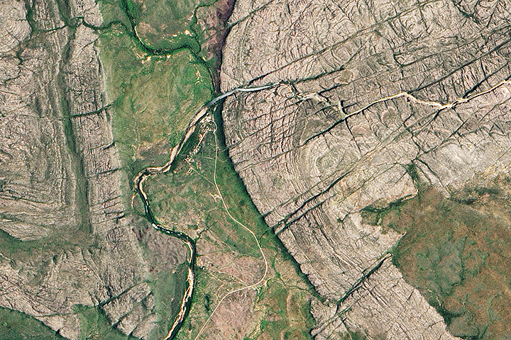
Each month, Earth Observatory offers up a puzzling satellite image here on Earth Matters. In celebration of Earth Month 2013, we’re upping the ante. We are going to release a new puzzler image every day this week. The third image is above. Your challenge is to use the comments section to tell us what part of the world we are looking at, when the image was acquired, and why the scene is interesting. We’ll post the answer to all five puzzlers at 6 p.m. EST on Friday, April 26.
How to answer. Your answer can be a few words or several paragraphs. (Try to keep it shorter than 200 words). You might simply tell us what part of the world an image shows. Or you can dig deeper and explain what satellite and instrument produced the image, what spectral bands were used to create it, or what is compelling about some obscure speck in the far corner of an image. If you think something is interesting or noteworthy, tell us about it.
The prize. We can’t offer prizes, but we can promise you credit and glory (well, maybe just credit). Later this week when we post annotated and captioned versions of the puzzler images as our Image of the Day, we will acknowledge the people who were first to correctly ID the images. We’ll also recognize people who offer the most interesting tidbits of information. Please include your preferred name or alias with your comment. If you work for an institution that you want us to recognize, please mention that as well.
Recent winners. If you’ve won the puzzler in the last few months, look at this week as a new challenge — can you get all five image locations?
Good luck!


John Walter Gregory’s Great Rift Valley. What is interesting about it if I am right is that it is where our speices began as well as its probable cause.
Angel Falls is a waterfall in Venezuela. It is the world’s highest uninterrupted waterfall, with a height of 979 m and a plunge of 807 m.
-Por el tipo de roca que aflora, la vegetación y la marca hidrográfica, Yo diría que es en algún lugar del Territorio del norte, en Australia. El tipo de roca es arenisca, con clara muestra por fracturas debido al tectonismo, pero fácilmente degradada por erosión del agua a través de ríos son evidencia del relieve.
Plunging folds, not sure where.
Anticline formations in Wymong’s Bighorn Range?
Pre-Cambrian Basement, road and air strip, looks semi arid. Very little shadow, near equator. Probably northwestern interior, Australia…
Applachian Mts.
Seem a periclinal closures with much erosion, but i think that is a batolite with fluid lines and erosioned diaclases. Sierra Nevada, Unide States.
May be waterfall, not sure what its is and where it is…But it seems that a river flowing on a rock bed and then turns its path according the down fall
Its a Water Fall of river … on a rock bed which is very high altitude…
The image is of the entrance to northern Australia’s Nitmiluk National Park (formerly Katherine Gorge National Park). North is to the top of the photo, which is roughly 13 km (8 miles) wide. The Katherine River forms a gorge, flowing from east to west through joints in the Kombolgie Formation (sandstone and conglomerate) of the Arnhem Land Plateau. When it passes through the escarpment it enters the Seventeen Mile Valley and bends southward around the western hills, then runs southwestward for another 90 km (60 miles) to its confluence with the Daly River. The indigenous Jawoyn people are custodians of the national park, which is jointly managed by the Parks and Wildlife Service of Australia’s Northern Territory. The town of Katherine is roughly 20 km (12 miles) downstream from the intersection of the river with the bottom of the photo. The road winding up from the center bottom of the photo is the Gorge Road, which terminates at the park’s visitor center.
Credit to: R. B. Vaughan for the clue to look in northern Australia; Northern Territory Parks and Wildlife Commission websites and Wikipedia for background information; Google Earth for visual search and measurements.
Amazing! So great to see these found! Great work!
Good work!!!! ;D
1) Part of the world: Stromatolites-bearing folded layered structures of old age (mo than 3.5 Ma) with river and forest.
2) Time of image acquired: Daytime mainly (to see whole area).
3) Reason of interesting scene: Stromatolites are relict rocks of fossil on Earth. Images of Planet exploration by TV camera are compared with such folded structure as evidence of fossil life on the planets estimated for water fluids (on surface, interior or past ages).