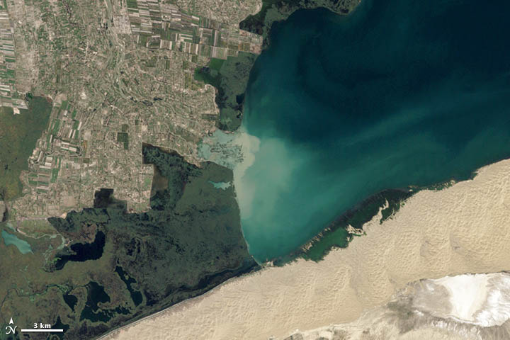
Every month, NASA Earth Observatory will offer up a puzzling satellite image here on Earth Matters. The third puzzler is above. Your challenge is to use the comments section below to tell us what part of the world we’re looking at, when the image was acquired, and what’s happening in the scene. Bonus points if you can do it in less than 2 hours and 56 minutes—the amount of time it took Alex Mathieu to successfully solve our first puzzler.
How to answer. Your answer can be a few words or several paragraphs. (Just try to keep it shorter than 300-400 words). You might simply tell us what part of the world an image shows. Or you can dig deeper and explain what satellite and instrument produced the image, what bands were used to create it, and what’s interesting about the geologic history of some obscure speck of color in the far corner of an image. If you think something is interesting or noteworthy about a scene, tell us about it.
The prize. We can’t offer prize money for being the first to respond or for digging up the most interesting kernels of information. But, we can promise you credit and glory (well, maybe just credit). Roughly one week after a “mystery image” appears on the blog, we will post an annotated and captioned version as our Image of the Day. In the credits, we’ll acknowledge the person who was first to correctly ID an image. We’ll also recognize people who offer the most interesting tidbits of information. Please include your preferred name or alias with your comment. If you work for an institution that you want us to recognize, please mention that as well.
You can read more about the origins of the satellite puzzler here. Good luck!


Drad sea perhaps? Definitely an irrigated area near a desert. Perhaps somewhere along the Mediterranean?
Not sure where this is… but the little striped squares in the north and east look like farm fields. The non-stripy part between the square fields looks maybe like an old river basin. You can see where it emptied into the large body of water in that whitish region in the center, where there’s a gap in the dark green. South of the farms and along the northern shore of the water, the dark green might be salt marsh? South of the water looks like sand dunes to me. I don’t see any cities. I’m looking forward to learning where this is and what all the features of the map are.
Whoops. I said north and east but I meant north and west, for the farms.
This is western Bosten Lake of Xinjiang in China. Cultivations, buildings and marshlands are juxtaposed with a sandy desert. At an altitude of above 1000m above sea level -yet with the lowest point in China located not far away- the freshwater lake and the Kaudi river that flows into it sustain a wide area of cultivated land where many towns and villages are located.
looks to be very similar.
The Dead Sea is part of a depression in the Earth’s crust between Africa and Asia, found on a rift where the two continents are pulling apart. It’s the lowest surface feature anywhere on Earth, located 1,300 feet below sea level?
Well the silted up river outlet (sandy/aqua) suggests its unlikely to be a river going into a sea or ocean, with major wetlands (dark green) centre to mid-left, suggests inland lake so freshwater …(shades of green/brown) looks like lots of small scale agriculture cropping (i.e. moderate to high population density) on maybe an alluvial plain from centre to upper left so likely to be other than Europe or North America, it’s nowhere in Australia I know; if lake is freshwater but no mountains or signs of jungle about prob not South America or SE Asia so leaves the highlands of central Asia; lots of sand dunes to the lower right; none of the big Russian or former USSR Reps seem to have lakes with a river feeding in with that level of agric development so prob China… then search the lakes of western China = Bositeng Hu
Good job, Yiannis!
The Wikipedia photo (November) shows a much greener area where it is pretty white at lower right, suggesting this photo may have been taken in the spring.
Jim, I agree with you that it should be spring or early summer. In the picture there are also flooded areas, perhaps from the increased flow of melted snow of the mountains that surround the basin where the lake is situated.
well, the green area you mention in wikipedia is water and here it has evaporated, the small, shallow lake has dried up.
There is an older “Image of the day” of the wider Taklimakan desert from Dec 3 2001 that shows the area in a late October caption. As it seems quite similar (the flooded areas) it could be even in autumn like the older image.
Great Job Yiannis!
Great puzzle, not many places on the earth with sand desert to the south and water to the west! Had me trekking in GE to some great places.