 |
|||
|
For five millennia, under the banners of nearly a dozen empires, through the preachings of countless religions, and amidst the technological marvels of the modern age, the Hamoun wetlands stood as a major source of food and shelter for the people of Central Asia. Located on the border of present-day Afghanistan and Iran and fed by the Helmand River, the 2,000-square-kilometer (800-square-mile) wetlands formed a true oasis in the middle of hundreds of kilometers of arid plains. The wetlands provided those around them with an abundant source of fish, game, and fresh water for farming. Their dense marshes and clear lakes supported all manner of wildlife from carp to otter to leopard. Their location far from any other substantial body of fresh water made them an ideal stop for migrating birds traveling south to the Indian Ocean.
|
Title graphic photo courtesy of Khorsheed.
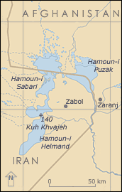 Sitting on the border of Iran and Afghanistan, the Hamoun wetlands are one of the few sources of fresh water in the arid plains of Central Asia. (Image courtesy of D. Del Pietro, UNEP GRID-Geneva) |
||
|
Within the past five years, however, the once fertile wetlands have deteriorated rapidly. Irrigation expansion throughout the 20th century coupled with one of the worst droughts ever witnessed in Central Asia have left the Hamoun nearly as arid as their surroundings. The wetlands have been replaced mostly by lifeless salt flats and decaying reed stands. The wildlife, the towns, the fisheries, and the agriculture that once surrounded the Hamoun have all fallen away, giving rise to a wasteland. Due to the remoteness of and conflicts surrounding the Hamoun, scientists of the last century did not have the opportunity to closely monitor the wetlands. Consequently, biologists and conservationists were unable to forecast the impending destruction of the wetlands. At present, they do not have a viable solution in place to reverse the damage. As part of a United Nations Environmental Program (UNEP) initiative to identify hotspots of environmental change around the world, researcher Hassan Partow decided to examine the degradation of the wetlands. Using Landsat satellite images provided in part by NASA, he pieced together a twenty-five-year history of the Hamoun wetlands. What emerged not only confirms the worst fears about the wetlands, but also may help bring about prompt action to restore them and wetlands like them all over the world.
The Demise of an Oasis |
|||
 |
 |
||
|
“The Helmand transformed one of the region’s common salt flats into a cradle of life,” says Partow. The Hamoun is one of the few sources of fresh water for hundreds of kilometers, and numerous species of plants and animals came to rely on its reeded shallows. Nearly 140 species of fish darted among the Hamoun’s waters. Fox, otter, deer, and leopards all foraged along the Hamoun’s banks. The wetlands were a major stopping point for many species of migrating birds, such as flamingos, ducks, and pelicans, making their way from Russia to the shores of the Indian Ocean. In fact, roughly 150 species of migrating and non-migrating birds could be found feeding and nesting in and around the wetlands over the course of a year (Partow 2003). For the past 5,000 years people have for the most part lived in harmony with the wetlands and their wildlife. An entire culture formed around the Hamoun with a way of life suited to the desert wetlands. They fashioned long reed boats to navigate the shallow waters and erected squat, red clay houses to withstand the heat of the desert. Their livelihood was based almost entirely on hunting, fishing, and farming. Not more than five years ago, the annual fish catch in the region topped 5,000 kilograms (12,000 pounds). Cattle, goat, and sheep ranchers tended over one million domesticated animals in the region. Farmers cultivated a wide range of fruits and vegetables around the Hamoun, including wheat, barley, millet, cotton, sugar cane, and even grapes and melons. “Irrigated agriculture has significantly expanded since the 1970s despite all the conflict in the region,” says Partow. He explains that until the late 20th century, irrigation waxed and waned in the Sistan basin for over 4,000 years without destroying the wetlands. The 20th century then brought both an increase in population and new, more efficient water management technologies to the region. Soon irrigation schemes began to snake their way throughout the basin. Farther west, revolving Afghan governments constructed large dams that diverted water from the upper reaches of the river. Surprisingly, the heavily irrigated wetlands remained vital almost until the turn of this millennium. “Periodic drought occurred several times in the past century, so that only the uppermost of the lakes, where the river drained, remained flooded,” says Partow. Each time, the region bounced back when the rains and floodwaters from the Helmand River returned. In 1998, drought once again descended on Central Asia, but this time the dry conditions persisted longer than anyone imagined. Between 1999 and the present, the region has suffered the worst persistent drought of any region in the world (Partow 2003). Compared to the long-term average, precipitation in the Sistan Basin dropped by 78 percent in 2001. Even the uppermost regions of the Hamoun began to dry. The combination of drought and the massive irrigation proved to be too big of a shock to the wetlands. The local fish and bird populations all but disappeared. Animals that could not sustain themselves in the desert or make the long journey to another oasis died. Winds that were once cooled by the waters of the wetlands now blew dust, sand, and salt from the lakebeds onto the surrounding villages. Up to 100 towns have been submerged by windblown dust thus far (Partow 2003). Most of the crops have been reduced to dustbowl conditions, hundreds of thousands of livestock have been lost, and every fishery has been closed. Just as with the Aral Sea disaster, many who had lived around the Hamoun for generations either moved away or lost everything. At the same time, a huge influx of refugees from Afghanistan moved in. “Sistan has become a focal point for refugees from all over Afghanistan, hosting an estimated 320,000. So it is difficult to separate environmental refugees from the fleeing of the war,” says Partow. The increase in people coupled with a severe drop in the quantity and quality of food resulted in increased risk of malnutrition, particularly among vulnerable groups like children and the elderly. Acute water shortages gave rise to an increase in diarrheal and communicable diseases.
Documenting the Hamoun Disaster |
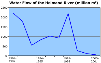
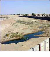
In 2001, the Helmand River at the Afghan-Iran border ran dry, falling by 98 percent from its annual average. (Image courtesy of International Federation of Red Cross and Red Crescent Societies) |
||
Among the best remote sensing instruments for monitoring this type of change are the Landsat instruments. Initiated by NASA in 1972, the Landsat program launched a series of satellites into polar orbits with the purpose of gathering scientific information on the Earth’s land surfaces. The first three satellites in the series, sent into orbit in the 1970s, could retrieve relatively coarse images of our planet using light sensors much like those found in a digital camera. These instruments could only detect a few bands (colors) of light. Later versions of Landsat have carried improved sensors — the Thematic Mapper instrument on Landsats 4 and 5 and the Enhanced Thematic Mapper Plus (ETM+) on Landsat 7, which was launched in 1999. The Thematic Mapper’s sensors record many bands of light emitted from and reflected off the Earth, including blue, green, red, near-infrared radiation, and even thermal radiation. From these satellite data, scientists can produce images of the Earth showing a single band of light or a combination of bands. With a resolution of 30 meters, the images still are not well suited for viewing anything smaller than an office building. They are, however, extremely useful for mapping and monitoring large features on the Earth, such as the Hamoun wetlands. “Landsat is the best suited satellite sensor for change detection because it covers the longest retrospective period of any satellite program, extending from the early 1970s to the present day,” says Partow. He was provided archived Landsat data by the Global Resource Information Database (GRID) in Sioux Falls, South Dakota, which was formed as a partnership between NASA, UNEP, and the U.S. Geological Survey (USGS). With the archived data, Partow had nearly 30 years worth of images of the wetlands to analyze. Using various combinations of bands from these images, he retrieved valuable information about the wetlands and the areas surrounding them. For instance, an image created from a combination of the red, near-infrared, and green bands (bands 4, 3, and 2) on the Enhanced Thematic Mapper would be useful for monitoring water and vegetation. Water and vegetation both absorb red light, whereas water reflects blue light and vegetation reflects near-infrared light. By analyzing images composed of these three bands, Partow could see how much water and vegetation have changed in the Hamoun. Urbanization and development, on the other hand, could be revealed in images created from thermal radiation, near infrared, and green bands (bands 8,7,4, and 2). |
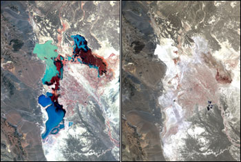
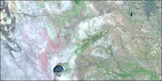
Left: In 1976, the Hamoun wetlands were still thriving. Dense reed beds appear as dark red, while tamarisk thicket fringing the margins of the upper lakes shows up as pink. Bright red patches represent irrigated agriculture, mainly wheat and barley. The lakes flood to an average depth of half a meter denoted by lighter shades of blue, while dark blue to black indicates deeper water s not exceeding four meters. Landsat MSS false color composite (bands 4, 2, and 1). Right: By 2001, the Hamoun wetlands had vanished after Central and South Asia were hit by the largest persistent drought anywhere in the world. The only sign of water in this scorched landscape of extensive salt flats (white) is the Chah Nimeh reservoir in the center right of the image, which is now only used for drinking water. Degraded reed stands in muddy soil are visible as dark red in the southern end of Hamoun-i Puzak. Landsat 7 ETM+ false color composite (bands 4, 3, and 2). (Image courtesy of H. Partow, UNEP) For more information, see the high-resolution image for 1976 (969 KB) or 2001 (837 KB). |
||
 |
|||
|
The data and images from the satellite instruments confirmed what everyone had suspected. Due to a mixture of irrigation practices, urban development, dams, and drought, the wetlands and the surrounding area declined slowly through the seventies, eighties, and early nineties before drying out almost completely over the last few years. Prior to the drought, nearly 70 percent of the water that normally flowed into the Hamoun was being siphoned off, and the water flow along the lower Helmand River had been reduced by 98 percent. Today nearly all 4,000 square kilometers (1,500 square miles) of what was once the Hamoun is gone, leaving only a few patches of degraded reed stands in muddy soil. The rest of the wetlands now give off the harsh glare of dried salt flats. The only relatively large bodies of standing water are the reservoirs maintained for drinking water (Partow 2003). “It is difficult to single out with certainty a specific factor responsible for the sharp drop in water levels. There is little doubt that there are multiple forces of change at play here and that the key driving variables are irrigation and drought, which may be related to a process of climate change in the region,” says Partow. Researchers do not yet know how much of the drying is due to the drought and how much is due to irrigation. There is also some speculation that the drought over the entire region may be due to climate change. Ongoing research by the International Research Institute for Climate Prediction links the drought in Central Asia with increased temperatures and changes in wind and rainfall over large areas of the Indian and Pacific oceans. Such a correlation suggests the drought may be part of an overall climate change that coincides with a worldwide increase in higher surface temperatures. Partow warns, however, such theories must be treated with extreme caution. |
Landsat images reveal present-day and past urbanization. A recently built asphalt highway cuts through the middle of the Ramsar protected area, and the sprawling Iranian border town of Zabol (dark gray) sits in the top right-hand corner. Kuh Khvajeh, a volcanic plug with a flat top that provided the foundation for an ancient settlement, rests in the lower center section of the image. Before the drought, the plug stood as an island in the middle of the marshes. Landsat 7 ETM+ (Bands 8, 7, 4, and 2). (Image courtesy of H. Partow, UNEP) For more information, see the high-resolution image (437 KB). | ||
|
As to the wetland’s future, Partow explains that the outlook isn’t so good. “Wetlands are dynamic ecosystems and are fairly resilient to cyclical periods of drought, regressing back and forth between marsh and desert. Historically, however, these changes have taken place gradually. The prolonged drought could push the wetlands over the edge as it will become increasingly difficult for the reed beds to re-establish themselves in the sterile salt flats,” he says. He adds that urgent action is needed now, because the longer the world waits, the more difficult it will be to bring the wetlands and their complex web of life back to their former splendor. Though Partow’s involvement ends with this preliminary assessment, the UNEP is preparing a comprehensive environmental assessment of war torn Afghanistan, which is due to be launched on January 21, 2003. Depending on what the study uncovers, they may draft an outline suggesting ways to restore the wetlands. In the meantime, Iran has established lines of communication with the new government in Afghanistan. One of the major dams blocking water to the Sistan region is the Kajaki Dam located in central Afghanistan. The Taliban government closed the sluices to the dam in 1998 after a dispute with Iran. The new government in Kabul, however, agreed to open the sluices again in late October, and the water reached the Iranian border a few days later. The reintroduction of these waters is definitely a step in the right direction and may bring water to the uppermost salt pans once again, but much more will have to be done to restore the wetlands, including ensuring adequate water flow to sustain the ecosystem. |
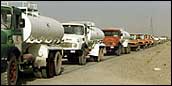 Trucks ferry in water to Afghan refugee camps and drought-stricken communities. (Image courtesy of International Federation of Red Cross and Red Crescent Societies) 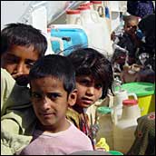 Children help with water collection at distribution points in an overall context of deteriorating public health. (Image courtesy of International Federation of Red Cross and Red Crescent Societies) |
||
|
References
The data used in this study are available in one or more of NASA's Earth Science Data Centers. |
|||
