 |
|||
If you lived anywhere along the Washington-New York corridor this February, you might have sworn you were somewhere else. The normally expressionless, brown landscape was uncommonly white, snow plows could be heard scraping the streets at all hours of the night, and those hiking boots collecting dust in the back of the closet had to be brought out simply to make the trip to the corner deli. In Baltimore, more snow fell in February than in any other month in recorded history. In the nation’s capital, the month proved to be the coldest February in a quarter century. And in Philadelphia and New York, the President’s Day storm of 2003 went down as one of the snowiest of all time. |
| ||
Meanwhile, 5,000 miles away in the equatorial Pacific, yet another El Niño was brewing. Trade winds across the Pacific had broken up and warm waters from the western Pacific had crept eastward. The natural thing to do, of course, would be to blame El Niño for the harsh winter conditions in the mid-Atlantic States. And why not? In the past, everything from fish deaths in the Pacific, high rainfall along the West Coast, tornadoes in the Midwest, and hurricanes off of Central America have been tied to the periodic Pacific Ocean warming. This year, however, our suspicions might at least be partially misplaced. Many climate experts are maintaining that the snows in the mid-Atlantic region may be due in part to yet another, lesser known, cyclical climate anomaly called the North Atlantic Oscillation (NAO). Despite the lack of publicity the NAO receives, its impact can be felt every winter around the entire Atlantic basin. Unlike El Niño, which occurs cyclically every three to seven years, the NAO appears to fluctuate randomly on a yearly basis. There are, however, slow variations in the NAO that point to an influence outside the atmosphere. |
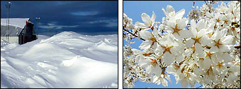
A strong North Atlantic Oscillation (large difference in pressure between the mid-latitude and tropical North Atlantic) tends to produce more severe weather in the North Atlantic, increased snowfall in Sweden (left), and an early spring in Washington, DC (right) [Photographs copyright Mark Schoeberl (left) & Barbara Summey (right)] | ||
Scientists around the world have been studying the NAO to understand what drives its variations and perhaps even to someday forecast its behavior. It is an elusive goal because of the NAO’s arrhythmic behavior. Researchers have had modest success, however, with short-term forecasts by linking the anomaly to sea-surface temperatures through statistical correlation. And over a longer time scale, they have discovered that global warming may be slowly influencing the strength of the NAO and its effect on the climate. |
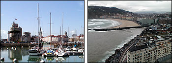
Typical weather caused by a negative NAO (small pressure difference between the mid-latitude and tropical North Atlantic) is fewer storms overall, clear skies over the Normandy coast of France (left,) and rain in Spain (right). (Photographs copyright Eric Simmon) | ||