
 | |||
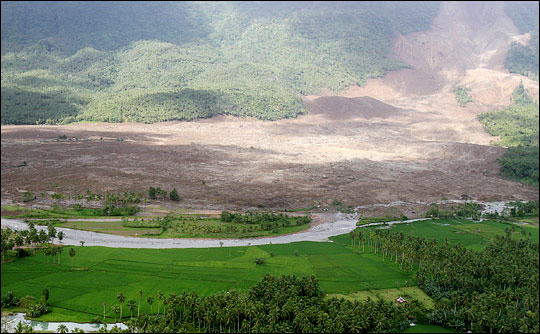
On February 17, 2006, the village of Guinsaugon on Leyte Island in the Philippines disappeared. After several days of unusually heavy rain, a massive landslide swallowed more than 350 houses and an elementary school, burying more than 1,100 people. Residents of the village, situated at the foot of a mountain, had no warning. | |||
 | |||
Landslides occur everywhere in the world, but the danger of rainfall-induced slides tends to be much greater in tropical mountainous regions like those in the Philippines, Central and South America, and southeastern Asia. Steep terrain and heavy tropical rains put dense populations at risk. Monitoring landslide-producing conditions typically requires extensive networks of ground-based rain gauges and weather instruments. But many of the developing countries in high-risk areas lack the resources to maintain such systems; heavy rains and flooding often wash away ground-based instruments. Robert Adler, a senior scientist in the Laboratory for Atmospheres at Goddard Space Flight Center, and Yang Hong, a research scientist at Goddard Earth Sciences Technology Center, are confronting the problem by developing a satellite-based system for predicting landslides. The system makes data available on the Internet just a few hours after the satellite makes its observations. Adler said, “If we can complete this ‘real-time’ product and make it available on the Web, then almost any government or organization in the world can access this information.” Mapping landslide susceptibilityRainfall is the key factor in Adler and Hong’s product, but first, they needed to piece together a global landslide susceptibility map, which would help reveal terrain and ground properties. Hong said, “Rainfall can be a trigger for landslides, but ground conditions are also very important.” Adler and Hong mapped topography, as well the direction that rivers and runoff would flow across the terrain. Satellite data helped the researchers determine land cover types, including forests, grasslands, wetlands, deserts, and urban areas. They also included information on soil composition and depth. The map revealed no surprises—the researchers already had a general idea which regions of the world were susceptible to landslides. “The most important factors are the slope and soil type. Steep slopes and coarse soil types are more susceptible to landslides,” Hong said. “And, in terms of land cover, bare soil contributes more to landslides.” The landslide susceptibility map provides a background against which the scientists could predict the effect of rainfall. |
After a week of heavy rains, a massive landslide covered the Philippine village of Guinsaugon, killing roughly half of the 2,500 residents. The landslide occurred mid-morning, burying a school full of students. A new early-warning system for landslides that uses NASA satellite rainfall data may save lives in remote mountain villages like Guinsaugon. (Photograph courtesy Lance Cpl. Raymond D. Petersen III, U.S. Marine Corps.) | ||
 | |||
Remotely sensing rainfallAdler and Hong’s primary source of rainfall data is the Tropical Rainfall Measuring Mission (TRMM), a joint NASA-Japanese Space Agency mission that launched in 1997. Adler said, “There are two main things that TRMM provides for this multi-satellite analysis. One, it’s the calibrator for the information from the other satellites. Two, it’s always in the tropics, and gives us very good coverage in a critical area.” TRMM orbits the Earth from west to east along the equator, weaving between 35 degrees north and 35 degrees south. Adler and Hong collect data from other satellites that are in polar orbits, traveling north to south around the Earth. “Because the TRMM orbit crosses over the paths of each polar-orbiting satellite, we’re able to collect subsets of data from both satellites at the same time,” Adler said. “We use TRMM data, which we think is making the best estimate, to calibrate, or adjust the rain estimates from the other satellites.” To test whether their rainfall product accurately detected landslide-triggering rain events, Adler and Hong identified 74 rainfall-induced landslides that occurred between the TRMM launch and 2006, including the Guinsaugon slide. Over the years, scientists have analyzed case studies of landslides to determine the intensity and duration of rainfall—usually measured at ground-based rain gauges—beyond which landslides become likely. Adler and Hong plugged their satellite-based rainfall data into equations that predicted when the rainfall at each landslide location would have reached the threshold. Their results closely matched previous threshold estimates, confirming that satellite observations could detect the extremely intense rainfall needed to trigger the slides. |
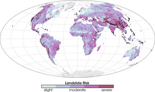
Black dots on this map identify the locations of landslides that occurred from 2003-2006 overlaid on a map of landslide risk. NASA scientists assembled the risk map from topographic data, land cover classifications, and soil types. Light blue indicates areas of low risk, while purple and dark red indicate areas at the highest risk. (NASA map adapted from Hong et al., 2006, by Robert Simmon.) | ||
 | |||
Real-time applicationsAdler’s and Hong’s satellite-based landslide-prediction products are available online and contain data from 2002 through the present. They are updated in “real time,” allowing anyone on the Web to determine if an area is receiving particularly intense rainfall or if it has reached a critical level of accumulation. People can download data or zoom in on geographic maps that display three-hour rainfall rates or seven-day accumulations. In addition, Hong is making hourly rainfall data available through Google Earth, a popular Web-based browser for viewing a collection of satellite and aerial views of the Earth overlaid with geographical and scientific information. |
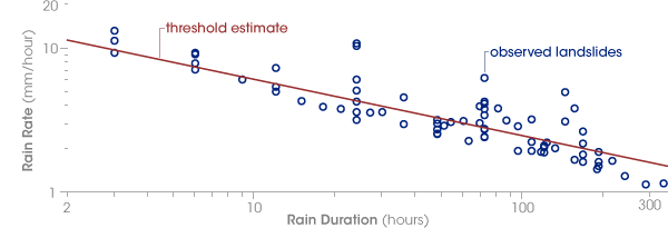
Adler and Hong examined the rain rate and rain duration that preceded 74 rainfall-triggered landslides to determine when the satellite data indicated a landslide threat. Each blue circle on this graph indicates a single landslide-triggering rain event plotted on a logarithmic scale. The intensity of rainfall events that triggered landslides measured by TRMM correspond with rain thresholds (red line) determined by earlier studies. (Graph adapted from Hong et al., 2006, by Robert Simmon.) | ||

| 
For now, the researchers consider the product to be in an “experimental” phase. They are still evaluating its potential and its limitations. Based on feedback from the system’s first users, they plan to refine the system to make it even more practical to local governments and disaster-response organizations on the ground. In remote, landslide-prone areas like Leyte Island, it can difficult for emergency planners to assess landslide hazards in time to prevent disasters. In these areas, a real-time, satellite-based monitoring system may ultimately save lives. “When national and international organizations have to plan disaster mitigation or relief work,” Adler said, “this system can give them quantitative information about where exactly the hazard is and which areas are affected. And that’s why I think that a lot of people are looking at this information. You don’t get it anywhere else.” About the scientists:Robert Adler is a senior scientist in the Laboratory for Atmospheres at Goddard Space Flight Center and a project scientist for the Tropical Rainfall Measuring Mission (TRMM). Adler’s research focuses on analyzing precipitation observations from space on global and regional scales using TRMM and other satellite data. Adler holds a PhD in meteorology from Colorado State University. Yang Hong is a research scientist at the NASA Goddard Earth Science and Technology (GEST) Center. His research interests include surface hydrology, remote-sensing of precipitation, flood forecasting and landslide analysis, and sustainable development. Hong received his PhD in hydrology and water resources from the University of Arizona, Tucson. This research was funded by NASA.
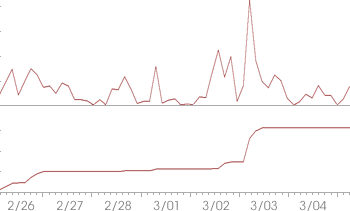
| Rain rate (left) and total accumulated rainfall (lower left) for western New Guinea measured over a week in late February and early March 2007 indicated the risk of a landslide. In fact, a landslide on March 4 killed nearly 100 people in the region. (Graph adapted from TRMM potential landslide areas.) | |